
Borgne
| Borgne | ||
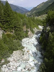
 The young Borgne d'Arolla |
||
| Data | ||
| Water code | CH : 109 | |
| location | Canton of Valais , Switzerland | |
| River system | Rhone | |
| Drain over | Rhone → Mediterranean | |
| confluence | of Borgne de Ferpècle and Borgne d'Arolla near Les Haudères 46 ° 4 ′ 57 ″ N , 7 ° 30 ′ 17 ″ E |
|
| Source height | 1422 m above sea level M. | |
| muzzle | near Sion in the Rhône coordinates: 46 ° 14 '38 " N , 7 ° 22' 57" E ; CH1903: 595 667 / 121391 46 ° 14 '38 " N , 7 ° 22' 57" O |
|
| Mouth height | 489 m above sea level M. | |
| Height difference | 933 m | |
| Bottom slope | approx. 31 ‰ | |
| length | approx. 30 km | |
| Catchment area | 385.99 km² | |
| Discharge at the estuary A Eo gauge: 385.99 km² |
MQ Mq |
11.96 m³ / s 31 l / (s km²) |
The Borgne is a river in the canton of Valais , about 30 kilometers long , which is created by the confluence of the Borgne de Ferpècle and Borgne d'Arolla near Les Haudères .
Their source rivers, which drain several glaciers between Dent Blanche (4357 m) and Pigne d'Arolla , are called Borgne de Ferpècle (from Ferpècle ) and Borgne d'Arolla (from Arolla ). Their confluence is at the village of Les Haudères . The Borgne flows first through a high valley and then through the deep gorges of the Val d'Hérens and finally flows into the Rhone near Sion . The river is diverted to the Lac des Dix in its upper reaches . The water quality of the river is slightly polluted. The river can be canoeed in spring when the snowmelts (May – June) or on hot summer days. The most important tributary is the Dixence , which comes from the Lac des Dix.
See also
Individual evidence
- ↑ a b Geoserver of the Swiss Federal Administration ( information )
- ↑ a b Modeled mean annual discharge. In: Topographical catchment areas of Swiss waters: sub-catchment areas 2 km². Retrieved August 20, 2017 .
photos

Source of the Borgne d'Arolla
Borgne de Ferpècle
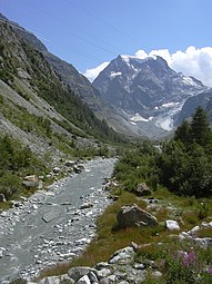
Borgne d'Arolla
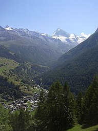
Valley of the Borgne de Ferpècle near Les Haudères with the Dent Blanche in the background.


