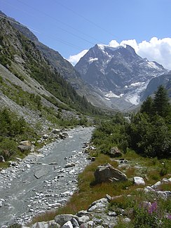
Borgne d'Arolla
|
Borgne d'Arolla Torrent de Bertol |
||
|
The Borgne d'Arolla with Mont Collon in the background |
||
| Data | ||
| Water code | CH : 110 | |
| location | Switzerland | |
| River system | Rhone | |
| Drain over | Borgne → Rhone → Mediterranean | |
| confluence | of two short melt streams of water below the Bertolgletschers 46 ° 0 '15 " N , 7 ° 30' 52" O |
|
| Source height | approx. 2815 m above sea level M. | |
| confluence | with Borgne de Ferpècle to Borgne Coordinates: 46 ° 14 ′ 38 ″ N , 7 ° 22 ′ 57 ″ E ; CH1903: 595 667 / 121391 46 ° 14 '38 " N , 7 ° 22' 57" O |
|
| Mouth height | 1422 m above sea level M. | |
| Height difference | approx. 1393 m | |
| Bottom slope | approx. 11% | |
| length | 12.9 km | |
| Catchment area | 90.3 km² | |
| Discharge at the mouth of A Eo : 90.3 km² |
MQ Mq |
3.5 m³ / s 38.8 l / (s km²) |
| Left tributaries | Torrent d'Arolla, Torrent des Aiguilles Rouges, Torrent de la Maresse, Bornetta | |
| Right tributaries | Torrent des Douves Blanches, Torrent de la Roussette, Torrent de Veisivi | |
| Communities | Evolène | |
The Borgne d'Arolla is the approximately 13 kilometers long left source river of the Borgne in the Swiss canton of Valais . It flows through the Val d'Arolla in the municipality of Evolène .
course
The Borgne d'Arolla arises at about 2815 m above sea level. M. at the confluence of two short meltwater streams that arise from the Bertol Glacier . This extends over the western slope of the Pointe de Bertol , which is a little south of the 3668 m above sea level. M. high Aiguille de la Tsa rises. After a short walk to the southwest, she reaches the Val d'Arolla, where the water of the Arolla Glacier flows in from the left . This has a much larger catchment area at the mouth than the Borgne d'Arolla. The young river turns to the northwest and from the right takes in the Torrent des Douves Blanches , which rises from the Glacier des Douves Blanches .
A little later she turns to the north-northeast and passes Arolla , which is above the river . Here at the Petit Praz campsite, it picks up the water of the Torrent de la Roussette from the right . It flows past Pramousse and Satarma , where the Torrent des Aiguilles Rouges flows in from the left, which is below 3262 m above sea level. M. high La Roussette rises. It passes La Gouille takes a short out from the right from Petite Dent de Veisivi ( 3184 m above sea level. M. herkommenden) Torrent de Veisivi on. Immediately afterwards, at La Ventura, the Torrent de la Maresse follows from the left, which rises at Mont de l'Etoile ( 3184 m above sea level ).
The Borgne d'Arolla now passes Pralovin and takes the Bornetta from the left, before it at 1422 m above sea level. M. just a little west of the village of Les Haudères with the Borgne de Ferpècle flows into the Borgne .
Individual evidence
- ↑ a b c Geoserver of the Swiss Federal Administration ( information )
- ↑ a b Topographical catchment areas of Swiss waters: sub-catchment areas 2 km². Retrieved August 20, 2017 .
