Ferpècle
| Ferpècle | ||
|---|---|---|
| State : |
|
|
| Canton : |
|
|
| District : | Hérens | |
| Municipal municipality : | Evolène | |
| Postal code : | 1985 | |
| Coordinates : | 608 595 / 101040 | |
| Height : | 1800 m above sea level M. | |
|
The scattered settlement in the valley of the Borgne de Ferpècle; View down the Val d'Hérens towards the Rhone Valley and the Bernese Alps |
||
| map | ||
|
|
||
Ferpècle at an altitude of around 1700 to around 1800 m above sea level. M. is a scattered settlement belonging to the municipality of Evolène in the upper Val d'Hérens in the French-speaking part of the Swiss canton of Valais .
geography
It stretches for about 5 km along the southeastern source stream of the Borgne ( Borgne de Ferpècle ) and includes the hamlets of Seppec , Pra Floric , Renoillin , Salay and, as the last building in the area of the tree line, a single café-restaurant. Five minutes earlier, the narrow access road ends on the slope high above the torrent.
The settlement
The traditional livelihood in the upper Val d'Hérens is alpine farming . The characteristic wooden chalets and extensive pastures for the cattle still shape the appearance of the scattered settlement at the beginning of the 21st century. Ferpècle is the starting point for various glacier and hut hikes as well as alpine ascents.
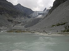
In the 19th century, a common glacier tongue from Ferpècle Glacier and Mont Miné Glacier reached almost as far as the settlement at the height of Salay ( 1766 m ). Since then, the glacier has been on the decline and divided into two glacier tongues, which constitute both sources of the Borgne de Ferpècle . From the café-restaurant, the lower tongue of the glacier on the Mont-Miné-Glacier (approx. 2000 m ) is reached after a 30-minute walk along the creek bed over rocks; in the headwaters the brook is widened to a shallow lake. The upper Ferpècle glacier is only visible after a two-hour ascent to the Bricola-Alpe (approx. 2400 m ).
Up until the middle of the 20th century, lakes dammed under the glacier ice, which suddenly emptied when ice broke, repeatedly caused flooding in the valley of the Borgne de Ferpècle. Since 1964, 1 km north of the source from the Mont Miné glacier, there has been a regulating small reservoir with a 28 m high barrier and 100,000 cubic meters capacity.
The Borgne near Ferpècle is integrated into the 420 km² catchment area of the world's second highest dam, the Grande Dixence , fed by 50 glaciers with a length of over 100 km. The feed tunnel from Ferpècle into the main line is 212 m.
Alpine hut routes and climbing tours
- Bivouac au Col de la Dent Blanche (3531 m) between Dent Blanche (4357 m) and Grand Cornier (3962 m); Eastern border to the German-speaking Valais in the area of the Matterhorn ;
- At the Ferpècle glacier Cabane de la Dent Blanche (3507 m) north of Wandfluehorn (3589 m) and Tête Blanche (3724 m); Southern border to Italy;
- At the Mont Miné glacier Cabane de Berthol (3311 m); southwest of it the Mont Collon (3637 m) near Arolla .
literature
- Hiking map Val d'Anniviers , Val d'Hérens, Crans-Montana , 1: 60,000, Kümmerly + Frey, 2006.
- Baedeker Switzerland, 9th edition 2000, p. 495
Web links
- Ferpècle on the ETHorama platform
- Research Institute for Hydraulic Engineering, Hydrology and Glaciology (VAW) of the ETH Zurich : Floods in Ferpècle. In: Glacier Natural Hazards. ( ethz.ch ( page no longer available ), also as a PDF ( page no longer available )).
Individual evidence
- ↑ Bricola-Alpe on ETHorama


