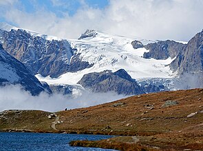
Zmutt glacier
| Zmutt glacier | ||
|---|---|---|
|
Zmutt Glacier with Matterhorn and Dent d'Hérens |
||
| location | Canton of Valais , Switzerland | |
| Mountains | Valais Alps | |
| Type | Valley glacier | |
| length | 6.5 km (1997) | |
| surface | 20.24 km² (1995) | |
| Exposure | Northeast nutrient area; Consumption area east | |
| Altitude range | 4100 m above sea level M. - 2235 m above sea level M. (1997) | |
| Tilt | ⌀ 11 ° (19%) | |
| Ice volume | 1.57 ± 0.93 km³ (1995) | |
| Coordinates | 615 363 / 94136 | |
|
|
||
| drainage | Zmuttbach → Matter Vispa → Vispa → Rhone → Mediterranean | |

The Zmutt Glacier is a valley glacier in the Valais Alps southwest of Zermatt , near the southern border of Switzerland . In 1997 the length was 6.5 km. In 1995 it covered an area of almost 20.24 km² including its tributary glaciers .
It takes its name from the summer settlement of Zmutt southwest of Zermatt.
location
The Zmutt Glacier is created below the Stockji ( 3,092 m above sea level ) from the union of three glacier arms . The main glacier is the Tiefmatten Glacier , which starts on the one hand at the western foot of the Matterhorn and on the other hand on the north and north-west flanks of the Dent d'Hérens . The second arm is the Schönbiel Glacier , which originates on the southern flank of the Dent Blanche and then flows south along the rocky ridge of the Wandfluh . The third tributary glacier is the Stockji glacier , which begins on the firn-covered Tête de Valpelline (3799 m above sea level), flows northeast, divides into two arms on the Stockji and is connected to both the Tiefmatten and Schönbiel glaciers. The Stockji is therefore a nunatak , a mountain completely surrounded by ice streams. The Zmutt glacier is located on the main Alpine ridge , precipitation is brought in from both the north and the south. In addition, avalanches make a significant contribution to accumulation .
After the union of the three glaciers, the Zmutt Glacier flows eastward, flanked by the Matterhorn in the south and the Ober Gabelhorn in the north. On this last section, the ice surface is covered by lateral and central moraine material as well as rubble that has loosened from the steep lateral slopes. The glacier tongue is at an altitude of about 2250 m. The Zmutt Glacier drains into the Zmuttbach , which joins the Gornera and Findelbach in the Zermatt basin to form the Matter Vispa , which flows through the Mattertal to the Rhone . Most of the water by far, however, is drained underground into the Lac des Dix after it has flowed through several sedimentation basins located below the glacier tongue, in which it is cleaned of silt, where it is used to generate electricity.
Since the high stage during the Little Ice Age around the middle of the 19th century, the Zmutt Glacier has retreated around 2 km by 2017. According to a study from 2019, the glacier area decreased from 21.24 km² to around 15.74 km² in 2013. Increasing rubble cover has temporarily slowed the loss of length and area, but the loss of mass has accelerated since the early 2000s (→ glacier retreat since 1850 ). The flow velocities of the glacier ice have decreased sharply.
North above the confluence of the Tiefmatten and Schönbiel glaciers is at 2694 m above sea level. M. the Schönbielhütte of the Swiss Alpine Club , which is the starting point for mountain climbs and extensive glacier tours.
literature
- AF Forel, M. Lugeon and E. Muret: Les variations périodiques des glaciers des Alpes. in: Yearbook of the SAC, volumes XXXIII / XLII. Staempli Bern, 1898–1907
- W. Haeberli: Frequency and characteristics of glacier floods in the Swiss Alps. Annals of Glaciology. Pp. 85-90, 1983
- F. Röthlisberger: Climate and glacier fluctuations in the post-ice age in the Zermatt, Ferpècle and Arolla area. in: Die Alpen , pp. 59–152, 1976
- L. Tufnell: Glacier hazards. Longman, London and New York, 1984
Web links
- Zmuttgletscher on the ETHorama platform
- Video impressions of the ascent from Zermatt through the Zmutttal to the Schönbielhütte
Individual evidence
- ↑ a b Research Institute for Hydraulic Engineering, Hydrology and Glaciology (VAW) of the ETH Zurich (ed.): Zmuttgletscher. In: Swiss Glacier Measurement Network. ( ethz.ch , also as PDF , accessed on January 2, 2013).
- ↑ a b Daniel Farinotti, Matthias Huss, Andreas Bauder, Martin Funk: An estimate of the glacier ice volume in the Swiss Alps. In: Global and Planetary Change. 68: 225-231, 2009 ( online ; PDF; 756 kB).
- ^ WGMS: Fluctuations of Glaciers Database. World Glacier Monitoring Service, Zurich 2013 ( DOI: 10.5904 / wgms-fog-2013-11 ), accessed on December 11, 2013
- ↑ a b Research Institute for Hydraulic Engineering, Hydrology and Glaciology (VAW) of the ETH Zurich : Zmuttgletscher. In: Glacier Natural Hazards. ( ethz.ch ( page no longer available ), also as a PDF ( page no longer available ), accessed on January 2, 2013).
- ↑ a b c Nico Mölg, Tobias Bolch, Andrea Walter, Andreas Vieli: Unraveling the evolution of Zmuttgletscher and its debris cover since the end of the Little Ice Age . In: The Cryosphere . July 2019, doi : 10.5194 / tc-13-1889-2019 .


