
Waschbergzone
| Waschbergzone (cliff zone, Inselbergschwelle) | ||
|---|---|---|
| Highest peak | Děvín ( 554 m nm ) | |
| location | Weinviertel / Lower Austria , Jihomoravský kraj | |
| part of | Weinviertel hill country , Subcarpathian region | |
|
||
| Coordinates | 48 ° 52 ' N , 16 ° 39' E | |
| rock | Limestone , marl limestone | |
| Age of the rock | Jura , education: Alpidic mountain formation , 17 mya | |
| particularities | Natura 2000 protected area (FFH) | |

The Waschbergzone , the portion lying on Austrian territory is also called Weinviertler Klippenzone , Niederösterreichische Inselbergschwelle or Weinviertler Hügelland , is a geological unit in the Lower Austrian Weinviertel and in South Moravia (Jihomoravský kraj).
Location and landscape
The Waschberg zone forms a strip that extends from the Waschberg ( 388 m above sea level ) and Michelberg ( 409 m above sea level ) near Stockerau over the Leiser Berge ( Buschberg as the highest elevation 491 m above sea level ), the Staatzer cliff ( 332 m above sea level ), the cliffs of Falkenstein ( 415 m above sea level ), the Schweinbarther mountain ( 337 m above sea level ) and the Šibeničník ( 238 m nm ) up to the Pollau mountains ( Děvín as the highest Elevation 554 m nm ) at Mikulov . In the north, the Pausramer unit and the Steinitzer unit connect to the Waschberg zone.
geology
The zone was created when two geological units - the Molasse Zone and the Vienna Basin - were pushed together around 17 million years ago in the course of the Alpidian mountain formation in the Lower Miocene . In the process, autochthonous rocks were scraped off from the subsoil, brought to the surface and now "swim", so to speak, in the surrounding marly cliff shell, without having a connection to the crystalline subsoil ( piercing cliffs ). The abraded rocks are primarily Jurassic limestone , but massive crystalline blocks can also be found. Since these rocks are harder than the surrounding molasse, which was removed more quickly by weathering, striking cliffs emerged over time , which give the landscape of the Waschberg zone its typical character and were used to build weir systems. The strip separates the western Weinviertel (Molasse zone) geologically from the eastern Weinviertel (Vienna Basin).
natural reserve
The Waschberg zone is one of the Natura 2000 protected areas ( FFH ).
photos
View from the west of the southern Waschbergzone (Steinberg, Grillenberg, Michelberg, Waschberg)

The natural monument "Teufelsstein" on the Waschberg mountain consists of two large granite shearers.

Semi-dry grass in the summit area of the Waschberg.

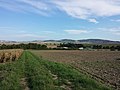
Michelberg near Stockerau

Buschberg , Steinmandl and Oberleiser Berg . Limestone piercing cliffs in the foreground.

Lawn steppes and limestone cliffs at Šibeničník near Mikulov

The Pollau Mountains with the Děvičky ruins


literature
- Godfrid Wessely : Geology of the Austrian Federal States, Lower Austria , Vienna 2006, ISBN 3-85316-239-8
Web links
Individual evidence
- ↑ noe.gv.at - map ( Memento from January 3, 2016 in the Internet Archive )
- ↑ noe.gv.at Brief description of the European protected areas ( Memento from November 26, 2015 in the Internet Archive )
- ↑ Thomas Hofmann: Geotopes in Lower Austria, in: Godfrid Wessely : Geology of the Austrian Federal States, Lower Austria , Vienna 2006