Pavlovské vrchy
| Pavlovské vrchy | ||
|---|---|---|
|
View from Stolová hora to Děvín |
||
| Highest peak | Děvín ( 549 m nm ) | |
| location | Jihomoravský kraj , Czech Republic | |
| part of | Mikulovská vrchovina , wash mountain zone | |
|
|
||
| Coordinates | 48 ° 50 ' N , 16 ° 39' E | |
| rock | Limestone, marl limestone | |
| surface | 44 km² | |
The Pavlovské vrchy , also Pavlovská vrchovina , Pavlovské bradlo , Pavlovské kopce , Polavské vrchy or Vrchy Pálavské (German Pollauer Berge , also Pollauer Gebirge ) are a mountain range in South Moravia , Czech Republic . They form the western part of the Mikulovská vrchovina .
geography
The Pavlovské vrchy rise to the right of the Thaya on the south bank of the reservoirs of Nové Mlýny. They have an area of 44 km² and an average height of 270 m nm. The settlements are Mikulov , Bavory , Klentnice , Perná , Pavlov , Horní Věstonice and Dolní Věstonice .
To the north, the valley of the Thaya forms the natural border with the Dolnomoravský úval ( southern March basin ). To the east, the valleys of the Klentnický potok and Mušlovský potok separate the Pavlovské vrchy from the Milovická pahorkatina . The Valtická pahorkatina ( Feldsberger Hügelland ) connects to the southeast . To the south the Pavlovské vrchy extend to the state border at the Polní potok / Ottenthaler Bach and Včelínek / Niklasgraben ; on Austrian territory the ridge continues as the Weinviertel hill country to the Falkenstein . The north-south extension from Maidenberg to Falkenstein is 20 kilometers. To the west - separated by the valley of the Dunajovický potok - the Dunajovické vrchy ( Tannowitz Mountains ) adjoin the Thaya, which already belong to the Dyjskosvratecký úval ( Thaya-Schwarza valley basin ).
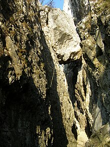
The Pavlovské vrchy are made of limestone and limestone marl . They are characterized by limestone cliffs and steep rock faces. Several karst caves have been created by karstification, the most famous being the Turold cave . The limestone was extracted in many places in limestone quarries, the Janičův vrch hill was mostly extracted by a limestone quarry. The forest areas are small, mostly only the steep slopes of the main peaks are forested. Gentle slopes and hills are used for agriculture, almost exclusively for viticulture .
Most of the Pavlovské vrchy has belonged to the 83 km² Pálava Protected Landscape Area since 1976 and to the Dolní Morava Biosphere Reserve since 1986 ( until 2003 the Pálava Biosphere Reserve ). There are nine nature reserves in the Pavlovské vrchy.
history
The steep rocky peaks with a wide view of the lowlands offered ideal locations for fortifications that were difficult to conquer. A fortified settlement was built on the Stolová hora during the Iron Age . Medieval castles and fortifications are the castles Waisenstein , Maidenburg , Neuhaus and Gaisburg . Nikolsburg , which was later converted into a castle, was also built on a rocky hill.
Significant surveys
- Děvín ( Maidenberg ), 549 m nm
- Obora ( Häuselberg ), 483 m nm
- Pálava ( Gemeindeberg ), 462 nm m
- Stolová hora ( Table Mountain ), 458 m nm
- Děvičky ( Maidenstein ), 428 m nm
- Růžový vrch ( Rosenstein ), 428 m nm
- Turold, 385 m nm
- Svatý kopeček ( Holy Hill ), 363 nm m
- Kočičí skála ( cat stone ), 362 m nm
- Kozí vrch ( Gaisberg ), 288 m nm |
literature
- Walter Sperling : Geographical names in the Bohemian countries - online dictionary in collaboration with the Collegium Carolinum ( archived version )
Web links
- Pavlovské vrchy on moravske-karpaty.cz
- Pavlovské vrchy on turistika.cz
- Tourist description town of Mikulov
- Pollauer Berge , website by Dieter Friedl


