Svatý kopeček u Mikulova
The Svatý kopeček u Mikulova (German Holy Mountain , older Tanzberg ) is a mountain east of the South Moravian town of Mikulov with a height of 363 m nm and belongs to the Pollau Mountains and the geological unit of the Waschberg zone . It is separated from the north-east adjoining Janičův vrch ( Marienberg ) by the erosion valley of the Mušlovský potok .
The rock massif consists of Jura limestone . Steep slopes lead to the plateau. The mountain is remarkable from several points of view.
nature

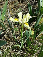
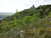
On the dry top of the mountain or its slopes, a shallow Pannonian lawn and rock steppe formed, which is home to many rare and endangered species. The warm, dry slopes are dominated by grasses such as Valais fescue ( Festuca valesiaca ), lime blue grass ( Sesleria caerulea ), dainty feather grass ( Stipa eriocaulis ), gray silk feather grass ( Stipa pennata ) and large feather grass ( Stipa pulcherrima ). The following species can be named as typical inhabitants of the rock and lawn steppes: mountain aster ( Aster amellus ), Austria tragacanth ( Astragalus austriacus ), long-flag tragacanth ( Astragalus onobrychis ), rock rock herb ( Aurinia saxatilis ), felt bellflower ( Campanula bononiensis) ), quilting bellflower ( Campanula sibirica ), upright clematis ( Clematis recta ), stained-blue knapweed ( cyanus triumfettii ) Diptam ( Dictamnus albus ), sun-needle florets ( Fumana procumbens ), Macaroni ( Galatella linosyris ) high stem-ball flower ( Globularia bisnagarica ), Christ- eye elephant ( Inula oculus-christi ), sand iris ( Iris humilis subsp.arenaria ), dwarf iris ( Iris pumila ), soft silver wedge ( Jurinea mollis ), narrow-flowered grape hyacinth ( Muscari tenuiflorum ), mugwort broomrape ( Orobanche artemisiae-campestris ), sand Blue Strangler ( Phelipanche arenaria ), Greater Pasque ( Pulsatilla grandis ), Illyrian-Buttercup ( Ranunculus illyricus ), finger -Steinbrech ( Saxifraga tridactylites ), mountain germander ( Teucrium montanum ), Stinking meadow rue ( Thalictrum foetidum ) Purple Mullein ( Verbascum phoeniceum ) and steppe violets ( Viola ambigua ). The northern slopes have long been afforested after the forest was cleared in 1816 to create a sheep pasture. The yellow dogwood ( Cornus mas ), the single-core hawthorn ( Crataegus monogyna ) and the stone wilt ( Prunus mahaleb ) as well as herbaceous plants the broad-leaf wood bird ( Cephalanthera damasonium ) and the snowdrop ( Galanthus nivalis ) grow in the forests and their borders. .
The insect fauna includes the praying mantis , the rose beetle , the stag beetle and the cockchafer . Several pairs of jackdaws nest in the towers of the sacred buildings, and eagle owls in the former quarry . As appearing herein reptiles are green lizard and smooth snake to call.
A 36.08 hectare area has been a plant reserve since 1946 . In 1992 it was declared a nature reserve.
St. Sebastian
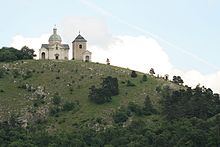
On the plateau of the mountain is the church of St. Sebastian , the foundation stone of which was laid on July 2, 1623. After the formal legal difficulties had been resolved, the consecration ceremony was held in 1679 . In 1717 the church was enlarged with a sacristy. In 1636 the bell tower was built as a separate structure. Due to the exposed location, lightning struck several times and destroyed or damaged the church and the bell tower.
In 1786, as part of the Josephine reforms , the church was closed, desecrated and the church furnishings were sold in the auction route . The property became the property of the Religious Fund.
Provost August Freiherr von Bartenstein received the approval in 1862 to collect donations for the rebuilding of the Sebastianskirche. In 1863 work could begin according to plans by the engineer Anton Tater . The rebuilt church was consecrated on September 8, 1865.
The Way of the Cross, which begins on the south side of the mountain, leads to the church . Up to the sixth chapel, the stations of the cross cannot be seen from afar, while from the seventh chapel onwards all are visible from afar. The construction of the Way of the Cross was started by Cardinal Franz von Dietrichstein in 1626. In 1776 the 14th Station of the Cross was built, with which the Way of the Cross was formally recognized as such under canon law. The consecration took place on September 1, 1776. In the course of the rebuilding of the church, the Way of the Cross was also renovated.
In addition to the Sebastian Church , the bell tower and the Stations of the Cross, chapels of Our Lady of Sorrows , Saint Barbara , Saint Rosalia and a holy grave were built on the Holy Mountain in 1692 . The initiators of these structures are not known.
The buildings on the Holy Mountain were damaged at the end of the war in 1945.
In 2010 the first sign of the Jakobsweg Weinviertel was set in this area , the signposts of which can be found in the Weinviertel in Lower Austria to Krems .
literature
- Theodor R. Seifert: The mountain church (Sebastianskirche) on the Hl. Berge near Nikolsburg , Verlag A. Bartosch, Nikolsburg, 1935
Web links
Individual evidence
- ^ List of plant species threatened with extinction in the Czech Republic
- ↑ Information board on site
- ↑ Nature reserves in and around Mikulov, accessed on January 5, 2015
- ↑ Jakobsweg Weinviertel ( page no longer available , search in web archives ) Info: The link was automatically marked as defective. Please check the link according to the instructions and then remove this notice. Retrieved June 23, 2010
- ^ Fritz Peterka: Jakobs- and Marienpilgerweg. Moravia and Weinviertel. Brno - Krems / Mautern , Wienerland publishing house, Langenzersdorf, 2010
Coordinates: 48 ° 48 ′ 25.2 " N , 16 ° 38 ′ 53.5" E


