Jakobsweg Weinviertel
| Jakobsweg Weinviertel | |
|---|---|
 Destination of all the Way of St. James: Cathedral of Santiago de Compostela |
|
| Data | |
| length | 162 km |
| location | Weinviertel |
| Starting point |
Mikulov 48 ° 48 '25.2 " N , 16 ° 38' 53.5" E |
| Target point |
Mautern on the Danube 48 ° 23 ′ 37 " N , 15 ° 34 ′ 39" E |
| Type | Long-distance hiking trail |
| Height difference | 309 m |
| The highest point | 476 |
| Lowest point | 167 |
| Level of difficulty | light |
| season | all year round |
The Jakobsweg Weinviertel is the 152-kilometer-long Weinviertel branch, which has been signposted since 2010 and runs from Drasenhofen in northeastern Lower Austria to Krems an der Donau. It is part of the Austrian Jakobsweg network .
As an Austrian - Czech long-distance hiking trail, it connects Mikulov in Moravia and Mautern on the Danube in Lower Austria . The route is a section of the Via Francigena running from Northern and Eastern Europe towards Rome or the Via Slavica leading from Brno to Vienna or Krems and Mautern on the Danube .
The Way of St. James runs in the Moravian region Jihomoravský kraj and in the three Lower Austrian quarters Wein- , Wald- and Mostviertel , whereby the route leads through one Moravian, 22 Weinviertel, three Waldviertel and one Mostviertel municipality. The communities, market towns and cities concerned are located in Okres Břeclav (1) and in the districts of Mistelbach (8), Korneuburg (8), Tulln (5), Krems-Land (4) and Krems-Stadt (1). In 39 churches along the Weinviertler Camino de Santiago, a pilgrimage temple can be picked up (there is not a complete list of punches points on), among which are the Jakob Churches in Falkenstein , Leitzersdorf , Etsdorf , Brunn in the field, Gedersdorf and Bürgerspitalskirche in Krems .
Of Drasenhofen to Ernstbrunn the Weinviertler Pilgrim approximately follows the Weinviertelweg 632 , in this section of the nature lovers is maintained local group Mistelbach and the Alpine Association. This is followed by care pieces from the mountain and hiking club Wienerland and the alpine club . In Mautern, the Weinviertel Jakobsweg joins the Jakobsweg Austria (section Jakobsweg Göttweig – Melk ).
The Jakobsweg in the Weinviertel touches the following landscapes, among others: Kamptal , Leiser Berge with the Buschberg , Rohrwald , Tullnerfeld , Wagram and Wachau . Most of the elevations on the way belong geologically to the Waschberg Zone , one of Lower Austria's Natura 2000 protected areas ( FFH ).
description
The joint project of the Archdiocese of Vienna , the Jakobsweg Weinviertel community of interests and Weinviertel Tourismus GmbH was developed with the help of private and public funds from 2007 to 2010 and marked with signs of different sizes, small panels and mussel bandaroles, but not consistently according to the guidelines of the Nö. Color-coded hiking trail concept.
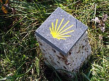
As part of a cross-class and interdisciplinary project work at the state vocational school Schrems, in cooperation with the Lower Austrian guild of stonemasons , marker stones were created from sandstone , limestone , granite , marble and conglomerate for the Jakobsweg Weinviertel, one in each of the Jakobsweg communities.
Shortly after it opened, the pilgrimage route developed into the most important tourism initiative in the Weinviertel.
The Jakobsweg Weinviertel begins on the Holy Mountain near Mikulov Svatý kopeček u Mikulova in the South Moravian town of Mikulov in the Okres Břeclav and initially leads across the Austrian border into the Lower Austrian district of Mistelbach to the municipality of Drasenhofen with the parish church of Sankt Veit and the villages of Kleinschweinbarth and Stützenhofen the baroque parish church of Falkenstein, first mentioned in a document in 1069 .
Past the Galgenberg at 425 m above sea level. A. and the city of Poysdorf you can reach the pilgrimage church Maria Bründl in Wilhelmsdorf , built by Donato Felice d'Allio from 1740 to 1751 .
The next destination is the pilgrimage church Maria Rast in the district capital Mistelbach, the third largest city after Krems and Stockerau along the Weinviertel Way of St. James.
The pilgrimage route crosses the Leiser Wald in the Leiser mountains with the communities Asparn , Gnadendorf , Ladendorf and Niederleis and reaches the Buschberg at 491 m above sea level. A. its highest point before in the community he in Maria Oberleis Ernstbrunn the District Korneuburg reached. The Oberleiser Berg is an area where people already settled two thousand years before Christ. The Celts settled there around five hundred BC and a Roman watchtower from the Danube Limes dates back to 100 AD.
From Ernstbrunn there are two ways to get to Karnabrunn: 1) directly and on nature trails and forest on Rohrwaldweg 633 or 2) further and mostly on roads and field paths via Großrußbach and further via the village of Weinsteig to the Holy Trinity Church in Karnabrunn . At the chapel on the Michelberg in the village of Haselbach in the market town of Niederhollabrunn is 409 m above sea level. A. on the way through the market town for Harmannsdorf belonging Rohrwald happen again one of the highest points of the way. The 388 m above sea level. A. Somewhat lower Waschberg is located in the municipality of Leitzersdorf , where there is a St. James' Church in the center of the village , the oldest part of which dates from 1200.
The city of Stockerau is the second largest city on the Weinviertel Way of St. James after Krems and at the same time the largest city in the Weinviertel. It has a beautiful old town with the baroque parish church consecrated to St. Stefan with the highest church tower in Lower Austria .
The next notable places are Hausleiten with the parish church , which is consecrated to Saint Agatha , Stetteldorf am Wagram with the church consecrated to Saint John the Baptist , Absdorf with the Mauritius Church and Königsbrunn am Wagram . The pilgrimage church of Maria Trost can be seen from afar. From there the Way of St. James leads to Engelmannsbrunn and on to Fels am Wagram with the Margareta Church.
While Feuersbrunn belongs to the market community Grafenwörth , Etsdorf with the Jakobskirche first mentioned in 1230 is a cadastral community of the market community Grafenegg . A few kilometers after Etsdorf, the Jakobspilgerweg leaves the Weinviertel over a Kamp bridge in the direction of Waldviertel, where you hike westwards along the Kamp until shortly before Brunn im Felde (Jakobskirche, first mentioned in 1355) in the community of Gedersdorf .
Shortly before the city of Krems, the trail climbs again slightly and leads above the market town Rohrsdorf to Krems , where in the pedestrian zone , the Saints James and Philip consecrated Bürgerspitalskirche located. The connection to the Jakobsweg Austria section Göttweig-Melk ( Wachauer Jakobsweg ) can be reached via the Danube bridge west of Krems leading to Mautern an der Donau .
Project presentation
The Jakobsweg Weinviertel project - In the footsteps of the Weinviertel pilgrimage route was initiated by Episcopal Vicar Matthias Roch and Landtag President Edmund Freibauer in the summer of 2007 in Santiago de Compostela and in January 2008 in the Weinviertel.
This was preceded by pilgrimages to the well-known pilgrimage sites in the Weinviertel from 2003 , which were organized by various parishes. The Großrußbach educational center of the Vicariate Unter dem Manhartsberg of the Archdiocese of Vienna was in charge of the Jakobsweg Weinviertel interest group .
Finally, a Leader + project was submitted, approved and implemented through the four Leader regions “Wachau-Dunkelsteiner Wald”, “Kamptal-Wagram”, “ Weinviertel-Donauraum ” and “Weinviertel-Ost”. The project costs were estimated at around € 110 thousand. The opening took place on Easter Monday 2010 in Großrußbach.
literature
- Ingrid and Werner Kraus: The Jakobswegweiser - Jakobsweg Weinviertel. Weinviertel Tourismus, Poysdorf 2010, ISBN 978-3-7056-1672-1 . (with cartography by Schubert & Franzke, St. Pölten, based on maps from the BEV - Federal Office for Metrology and Surveying in Vienna)
- Fritz Peterka: St. James and St. Mary's Pilgrimage Trail - Moravia and Weinviertel - Brno - Krems / Mautern. Langenzersdorf 2010, ISBN 978-3-900451-46-2 . (The description follows the marked route Drasenhofen - Ernstbrunn (632) - Karnabrunn - Goldenes Bründl (633) - Stockerau (Coppelweg) - Krems (675))
- Maximilian Bogner: Jakobsstellen: Jakobskirchen, Jakobskapellen, Jakobsorte. (PDF; 388 kB)
Web links
- Number of page views
- Way of St. James Austria
- www.jakobsweg-weinviertel.at Official homepage for the Jakobsweg Weinviertel
- Outdooractive - Jakobsweg Weinviertel
- Homepage of the mountain and hiking club Wienerland, pather of the Ernstbrunn - Stockerau stage
Individual evidence
- ↑ Jakobsweg Weinviertel ( page no longer available , search in web archives ) Info: The link was automatically marked as defective. Please check the link according to the instructions and then remove this notice. Homepage of the city of Mistelbach
- ↑ Jakobsweg in the Weinviertel region
- ↑ Project information Jakobsweg Weinviertel (PDF; 3.7 MB)


