Okres Břeclav
| Okres Břeclav | |
|---|---|
| Kraj | Jihomoravský kraj |
| surface | 1037.95 km² |
|
Inhabitants • Population density |
115,906 ( January 1, 2019 ) 111 inhabitants / km² |
|
Municipalities • of which cities • of which Městyse |
63 9 4 |
| LAU 1 | CZ0644 |
|
Vehicle registration number (issued until 2001) |
BV |

|
|
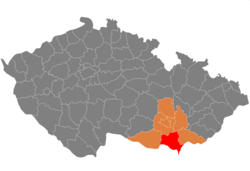
The Okres Břeclav (German: District Lundenburg ) is located in the southeastern tip of Moravia in the south of the South Moravian Region .
geography
The area is 1049 km², the population about 114,000 (2007). 68% of the area can be used for agriculture, 16% is covered by forests. In agriculture, wine is mainly grown, along with fruit and vegetables. There are 63 communities in the area, nine of which are cities.
In addition to large deposits of sand, there are also oil and gas deposits in the district . 27% of the workforce is employed in industry (plastics, chemicals, mechanical engineering, printing, food), 14% in trade, 10% in construction and 9% in agriculture. Unemployment is well above the average and is around 10.6%
Attractions
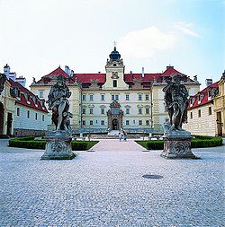
The region around Lundenburg ( Břeclavsko ) has numerous vineyards and large fields and has numerous historical monuments, in which many folkloric events take place. There are also two of the field UNESCO protected monuments of world cultural heritage . This includes the Pálava nature reserve with white limestone rock landscapes and the relief of the Pollau Mountains ( Pavlovské vrchy ) as well as the Lednice-Valtice cultural landscape - the first parkland in the Czech Republic.
- Pohansko Castle in Empire style with an exhibition of archaeological finds from the area.
- Pohansko monument reserve with a Slavic fortress from the early 9th century .
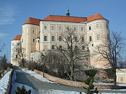
- Mikulov with its castle and the most beautiful city gate in the Czech Republic.
- Museum in Dolní Věstonice with an overview of the most important excavations of the 20th century. Attached is an exhibition about the life of the mammoth hunters and excavations from the Stone Age .
cities and communes
Bavory ( Pardorf ) - Boleradice ( Poleraditz ) - Borkovany ( Borkowan ) - Bořetice ( Boretitz ) - Brod nad Dyjí ( Gulden ford ) - Brumovice ( Brumowitz ) - Breclav ( Lundenburg ) - Březí ( Bratelsbrunn ) - Bulhary ( Pulgram ) - Diváky ( Diwak ) - Dobré poles ( Guttenfeld ) - dolní dunajovice ( Untertannowitz ) - dolní věstonice ( Unterwisternitz ) - Drnholec ( Dürnholz ) - Hlohovec ( Bishop Wart ) - horní bojanovice - Horni Věstonie ( Oberwisternitz ) - Hrušky ( Birnbaum ) - Hustopeče ( Auspitz ) - Jevišovka ( Fröllersdorf ) - Kašnice ( Kaschnitzdorf ) - Klentnice ( Klentnitz ) - Klobouky u Brna ( Klobouk ) - Kobylí ( Kobyli ) - Kostice ( Kostitz ) - Krumvíř ( Grumwirsch ) - Křepice ( Krepitz ) - Kurdějov ( Gurdau ) - Ladná ( Rampersdorf ) - Lanzhot ( Landshut ) - Lednice ( Eisgrub ) - Mikulov ( Nicolsburg ) - Milovice ( Millowitz ) - Moravská Nova Ves ( Neudorf ) - Moravský Žižkov ( Zischkam ) - Morkůvky ( Morkuwek ) - Němčičky ( Kleinniemtschitz ) - Nikolčice ( Nikoltschitz ) - Novose dly ( Neusiedl ) - Nový Přerov ( Neuprerau ) - Pavlov ( Pollau ) - Perná ( Bergen ) - Podivín ( Kostel ) - Popice ( Poppitz ) - Pouzdřany ( Pausram ) - Přítluky ( Prittlach ) - Rakvice ( Rakwitz ) - Sedlec ( Voitelsbrunn ) - Starovice ( Großsteurowitz ) - Starovičky ( micro Euro wit ) - Strachotín ( dress ) - Šakvice ( Schakwitz ) - Šitbořice ( Schüttborzitz ) - Tvrdonice ( Turnitz ) - Týnec ( Teinitz ) - Uherčice ( Auerschitz ) - Valtice ( Feldberg ) - Velké Bílovice ( Bilowitz ) - Velké Hostěrádky ( Groß Hostichradek ) - Velké Němčice ( Großniemtschitz ) - Velké Pavlovice - Vrbice ( Wrbitz ) - Zaječí ( Saitz )
The municipalities of Cvrčovice , Ivaň , Pasohlávky , Pohořelice , Přibice , Vlasatice and Vranovice belong to the Okres Brno-venkov since January 1st, 2007 .
Web links
Individual evidence
Coordinates: 48 ° 52 ' N , 16 ° 46' E

