Hlohovec (Czech Republic)
| Hlohovec | ||||
|---|---|---|---|---|
|
||||
| Basic data | ||||
| State : |
|
|||
| Historical part of the country : | Lower Austria | |||
| Region : | Jihomoravský kraj | |||
| District : | Břeclav | |||
| Area : | 896 ha | |||
| Geographic location : | 48 ° 46 ' N , 16 ° 46' E | |||
| Height: | 174 m nm | |||
| Residents : | 1,314 (Jan 1, 2019) | |||
| Postal code : | 691 43 | |||
| License plate : | B. | |||
| traffic | ||||
| Street: | Lednice - Valtice | |||
| structure | ||||
| Status: | local community | |||
| Districts: | 1 | |||
| administration | ||||
| Mayor : | Marie Michalicová (as of 2018) | |||
| Address: | Hlavní 75 691 43 Hlohovec u Břeclavě |
|||
| Municipality number: | 584452 | |||
| Website : | www.hlohovec.cz | |||
Hlohovec (German Bischofswarth ) is a municipality in the South Moravia region in the Czech Republic . It is located ten kilometers west of Břeclav and belongs to the Okres Břeclav (Lundenburg district). Hlohovec is registered as part of the Lednice-Valtice Cultural Landscape in the UNESCO World Heritage List.
geography
Hlohovec is located in the southeast of the Pollau Mountains on the right side of the Včelínek brook ( Niklasgraben ). The village is located on the Hlohovecký rybník , which forms with the Nesyt, Prostřední rybník and Mlýnský rybník along the Včelínek a system of four connected carp farming ponds with a total of approx. 600 ha.
Neighboring towns are Bulhary and Nejdek in the north, Lednice in the northeast, Charvátská Nová Ves in the east, Poštorná in the southeast, Valtice in the south, Úvaly in the southwest and Sedlec in the west.
history
Bischofswarth was first in Liechtenstein - Urbar mentioned the year 1414th The name referred to a raised point in the area, the Wartberg. In 1570 it was mentioned as a newly established village. This was probably the successor village of Allach ( Alosch ) and Königsbrunn, which were desolate in the 15th century and which were located north of Feldsberg. Most of the new immigrants were Croatians who were assimilated by Slovak immigrants over the centuries. Bischofswarth belonged to Lower Austria until 1919 , but was ceded to Czechoslovakia by the Treaty of St. Germain after the breakup of Austria-Hungary . After the Munich Agreement in 1938, it was added to the German Reich. After the end of the Second World War it fell back to Czechoslovakia.
The registers have originally been kept at Feldsberg since 1615 and are now in the Brno State Archives.
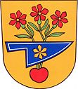
The place seal has been known since the last quarter of the 16th century. It shows a simple baroque shield with a heart at the base from which a young tree sprouts. Three branches grow out of the tree, each with an apple blossom. The tree is covered with a plow, which stands for agriculture.
Population development
| census | Total population | Ethnicity of the inhabitants | ||||
|---|---|---|---|---|---|---|
| year | German | Czechs | Others (Croatians) | |||
| 1793 | - | - | - | - | ||
| 1836 | 732 | - | - | - | ||
| 1869 | 753 | 0 | 640 | 113 | ||
| 1880 | 871 | 36 | 828 | 7th | ||
| 1890 | 981 | 28 | 947 | 6th | ||
| 1900 | 1.005 | 5 | 990 | 10 | ||
| 1910 | 1,219 | 152 | 1,066 | 1 | ||
| 1921 | 1.313 | 10 | 1,296 | 6th | ||
| 1930 | 1,425 | 13 | 1,403 | 9 | ||
| 1939 | 1,431 | - | - | - | ||
| Source: 1793, 1836, 1850 from: Frodl, Blaschka: South Moravia from A – Z. 2006 | ||||||
| Other: Historický místopis Moravy a Slezska v letech 1848–1960, sv.9. 1984 | ||||||
Attractions
- Branch Church of St. Bartholomew
- Hraniční zámeček castle on the Hlohovecký rybník (Bischofswarther pond)
The Grenzschlösschen was built between 1816 and 1827 on the border between Lower Austria and Moravia, as the inscription Between Austria and Moravia on the facade shows. The builder of the castle was Josef Poppelack , an architect and builder from Silesia . It was not until 1920 that the state border was moved further south outside of Hlohovec.
- Rybniční zámeček pond castle, northeast of the village on Prostřední rybník (Mitterteich) near Eisgrub
- Debris hill from the Aloch Fortress, south of the village
Web links
- Cultural database of displaced persons
- The Grenzschlössel in Bischofswarth (PDF file; 946 kB)
- Video impressions
Individual evidence
- ↑ http://www.uir.cz/obec/584452/Hlohovec
- ↑ Český statistický úřad - The population of the Czech municipalities as of January 1, 2019 (PDF; 7.4 MiB)
- ^ Felix Ermacora : The unreached peace: St. Germain and the consequences; 1919-1989 , Amalthea Verlag, Vienna, Munich, 1989, ISBN 3-85002-279-X
- ↑ Gerald Frodl, Walfried Blaschka: The district of Nikolsburg from AZ, 2006, Bischofswarth page 47
- ↑ Acta Publica Online search in the historical registers of the Moravian Provincial Archives Brno (cz, dt). Retrieved March 9, 2011
- ^ Liechtenstein Archive Vaduz / Vienna 1378, 1401, 1413: Archives of the Lower Austrian Provincial Government; Okresní archive / B Nikolsburg.
- ↑ Grenzschlösschen (Hraniční zámeček) on CzeCOT.cz accessed on May 13, 2010


