
Waschberg (Lower Austria)
| Waschberg | ||
|---|---|---|
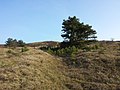
 Semi-dry grass in the summit area |
||
| height | 388 m above sea level A. | |
| location | Lower Austria | |
| Dominance | 1.4 km → Michelberg | |
| Notch height | 40 m ↓ south of Michelberg | |
| Coordinates | 48 ° 25 ′ 19 ″ N , 16 ° 16 ′ 21 ″ E | |
|
||
| rock | Waschberg limestone, slate clay marl (partly with block layers) | |
| Age of the rock | Eocene , Miocene | |
| particularities | Semi-arid grassland of national importance | |

The Waschberg is 388 m above sea level. A. high mountain in the municipalities of Leitzersdorf and Niederhollabrunn in the Korneuburg district in Lower Austria . The geological unit of the Waschbergzone was named after him.
geology
The Waschbergzone begins at the Waschberg, a geological strip that continues over the Michelberg ( 409 m above sea level ), the Leiser Berge ( 491 m above sea level ), the Staatzer Klippe ( 332 m above sea level ) and the Falkensteiner Klippen ( 415 m above sea level ) up to the Pollau Mountains ( 554 m nm ) in South Moravia . The zone was created when two geological units - the Molasse Zone and the Vienna Basin - were pushed together around 17 million years ago in the course of the Alpidian mountain formation in the Lower Miocene . In the process, autochthonous rocks were scraped off from the subsoil, brought to the surface and now "swim", so to speak, in the surrounding marly cliff shell, without having a connection to the crystalline subsoil ( piercing cliffs ). Since the limestone is harder than the shell, it was exposed by weathering and form distinctive landscape elements.
The summit area of the Waschberg is covered by a slab of Eocene limestone . This is to be assigned to the Waschberg Formation, which comes from the Ypresian to Lutetian . The Waschberg limestone is rich in nummulites and other fossils of earlier shallow water fauna. The summit area of the nearby Michelberg also has a cover plate from the Waschberg formation. The slope and foot of the Waschberg consist of slate clay marls from the Eggenburgium to the Ottnangium . In the southern and eastern area there is a strip that contains interspersed blocks of sandstone , marlstone , granite and gneiss .
One such scherling, a granite block carved up from the subsoil, is the Teufelsstein on the southern slope of the Waschberg. There is a legend about him , according to which the devil wanted to smash the well-frequented pilgrimage church on Michelberg with the help of a large boulder. When he finally got the rock into the air with unspeakable efforts, he was caught by the Archangel Michael and defeated after a short fight. The devil had to drop the block and it hit the Waschberg, where it is still today. The reddish color of the granite, ascribed to the blood of the devil, is actually due to iron compounds.
nature
The summit area of the Waschberg is covered by a semi-arid Pannonian brisket-feathered twine, which is classified as of national importance, as it is one of the last and few large semi-arid lawns in the Weinviertel . A typical species that occur here include real-agrimony ( Agrimonia eupatoria ), real-Betonie ( Betonica officinalis ), Greater Knapweed ( Centaurea scabiosa ), Alsace-Haarstrang ( Peucedanum alsaticum ), Black Pasque ( Pulsatilla pratensis subsp. Nigricans ) , Steppe armchair ( Seseli annuum ), small meadow rue ( Thalictrum minus ) and mountain clover ( Trifolium montanum ). On cracks in the earth there are small, gappy fescue fescue grasslands. Hawthorn bushes grow across the steppe , sometimes forming denser bushes. The increasing encroachment poses a threat; some areas have even been afforested in the past.
On Waschberg there is a colony of the endangered in Austria Ziesels as representatives of the steppe fauna.
The Waschberg is part of the Natura 2000 protected area ( FFH ) "Weinviertel cliff zone".
history
From October 13 to 21, 1923, the 1st Austrian Gliding Week took place on the Waschberg, a memorial stone commemorates this.
photos

View of the Waschberg from the southwest.

View from the Waschberg towards Stockerau .

View to Leitzersdorf in the west.

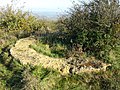
View to the southeast, in the foreground a former quarry.

Wash mountain limestone rocks on the summit plateau.
Endangerment of the semi-arid grass by spreading, alien red pines ( Pinus sylvestris ).

The Teufelsstein on the southern slope of the Waschberg is a shearling made of reddish granite.
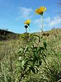
The bovine eye ( Buphthalmum salicifolium ) is a limestone inhabitant of grasslands.

The common fringed gentian ( Gentianopsis ciliata ) can only be found on limestone soils.

Memorial stone that commemorates the 1st Austrian gliding week.
Remnants of the foundations of a radio measuring system that was built on the Waschberg during the Second World War .


Individual evidence
- ↑ a b Godfrid Wessely : Geology of the Austrian federal states, Lower Austria. Vienna 2006, ISBN 3-85316-239-8 , pp. 16, 69ff.
- ↑ Geologische Bundesanstalt (Ed.): Geological map of Lower Austria 1: 200 000, Lower Austria North. Vienna 2002.
- ↑ Thomas Hofmann: Sagenhaftes Niederösterreich, A search for traces between myth and truth , Vienna 2000, ISBN 3-85431-198-2 , p. 87ff
- ↑ Wolfgang Holzner et al .: Austrian dry grass catalog. “Steppes”, “heaths”, dry meadows, poor meadows: existence, endangerment, possibilities of their conservation. In: Green series of the Federal Ministry for Health and Environmental Protection , Volume 6, Vienna 1986, ISBN 3-900649-06-5 , p. 121, object ÖK 40/15
- ^ Margit Gross & Hans-Martin Berg: Occurrence and protection of the ground squirrel (Spermophilus citellus) in Lower Austria. Report, published by the Naturschutzbund Niederösterreich, 2006. http://www.denoe-naturschutzbund.at/PDF/Ziesel_Endbericht_kurz.pdf (link not available)
- ↑ noe.gv.at - map ( Memento from January 3, 2016 in the Internet Archive )
- ↑ noe.gv.at Brief description of the European protected areas ( Memento from November 26, 2015 in the Internet Archive )
- ^ A b Manfred A. Fischer, Karl Oswald, Wolfgang Adler: Excursion flora for Austria, Liechtenstein and South Tyrol . 3rd, improved edition. State of Upper Austria, Biology Center of the Upper Austrian State Museums, Linz 2008, ISBN 978-3-85474-187-9 .