
Staatzer cliff
| Staatzer cliff | ||
|---|---|---|
.JPG) Staatz castle ruins on the Staatzer cliff |
||
| height | 332 m above sea level A. | |
| location | Staatz , Austria | |
| Mountains | Waschbergzone | |
| Dominance | 2.8 km → St. Johannes near Wultendorf | |
| Notch height | 100 m ↓ near Kautendorf | |
| Coordinates | 48 ° 40 ′ 35 " N , 16 ° 29 ′ 22" E | |
|
||
| Type | Impaling cliff | |
| rock | organodetritic limestone | |
| Age of the rock | Tithonium | |

A striking limestone cliff in the Lower Austrian Weinviertel (municipality of Staatz ) is called Staatzer Klippe or Staatzer Berg . Geographically, the Staatzer Klippe belongs to the Subcarpathian Mountains and towers over the slightly hilly landscape by around 100 meters, visible from afar. The hill has a height of 332 m above sea level. A. and is located in the municipality of Staatz. The slopes are home to remarkable rock steppes and dry grasslands of regional importance. The Staatz castle ruins are at the top .
geology
The Staatzer cliff is part of the Waschbergzone , also known as the Weinviertel cliff zone, a geological strip that stretches from the Waschberg ( 388 m above sea level ) and Michelberg ( 409 m above sea level ) near Stockerau over the Leiser Berge ( 491 m above sea level). A. ), the Staatzer cliff ( 332 m above sea level ) and the cliffs of Falkenstein ( 415 m above sea level ) up to the Pollau mountains ( 554 m nm ) in South Moravia . The zone was created when two geological units - the Molasse Zone and the Vienna Basin - were pushed together around 17 million years ago in the course of the Alpidian mountain formation in the Lower Miocene . Autochthonous rocks were scraped from the subsoil, brought to the surface and now “swim”, so to speak, in the surrounding marly cliff shell without having a connection to the crystalline subsoil ( pierced cliffs ). The cliff consists of organodetritic limestone of the Ernstbrunn Formation, which comes from the Tithonium . Since the limestone is harder than the shell, it was exposed by erosion and forms a striking landscape element that rises from the rather flat surrounding area.
nature
Because of the fortification use, the mountain was largely kept clear of woody plants for centuries , as these would have blocked the view of attackers or provided cover. The resulting dry, warm rock and turf steppes offered a habitat for species whose natural occurrence lies much further to the east in the primary steppe areas and which had immigrated since the Neolithic period after the settled people cleared the largely forested land. A remarkable Pannonian vegetation was able to develop, which includes species rare in Austria such as the steppe pointed keel ( Oxytropis pilosa ), the gray horehound ( Marrubium peregrinum ) and the lettuce ( Lactuca viminea ). After the castle was destroyed, the areas were probably periodically burned down or perhaps grazed and thus kept open. Graphic representations and aerial photographs show that the cliff was largely bare until the beginning of the 20th century. From the 19th century onwards, alien species were intentionally introduced - by aristocratic rulers to "beautify the landscape" - or unintentionally. During the sub-Mediterranean smoke tree ( Cotinus coggygria ) should be regarded as harmless by the afforestation of were arborvitae ( Thuja orientalis valuable) habitats destroyed. Other alien species such as the common lilac ( Syringa vulgaris ) and the tree of gods ( Ailanthus altissima ) also behave invasively , displacing species worthy of protection and partially migrating into the dry grassland . Both species are difficult to control because they respond with countless stick and root blows when they are cut . The cliff including the castle ruins was declared a natural monument on January 23, 1978. In the last few decades, however, the trees were no longer regularly removed, which is why they could spread and the cliff is already largely forested or covered with bushes. Without maintenance measures, the remaining grass and rock steppes threaten to overgrow and disappear together with the rare species.
use
Staatz Castle was built on the strategically located cliff in the 11th century . In 1645 the castle was destroyed by Swedish troops and has been in ruins ever since.
At the foot of the cliff is the Staatz Felsenbühne , which with 1,200 seats is one of the largest open-air stages in Lower Austria and is regularly played with musicals in summer.
photos

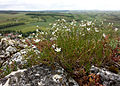
Rock steppe with the steppe pointed keel ( Oxytropis pilosa ), which is highly endangered in Austria . In the background a wall of the castle ruins.
View from the cliff, in the foreground the bristle Miere ( Minuartia setacea ), which is endangered in Austria .
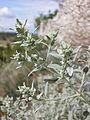
The gray horehound ( Marrubium peregrinum ) that occurs on the cliff is considered endangered in Austria.

The deeply pinnate leaves of the tail lettuce ( Lactuca viminea ), which is endangered in Austria, are optimally adapted to the dryness of the rocky slopes.

The sub-Mediterranean European wig bush ( Cotinus coggygria ) is a cultural relic.

Invasive lilac bushes invade the rock steppe.

The rock steppe can be restored by means of de-bushing work, as here by the nature conservation association and local helpers.

Rocky slope already heavily overgrown by trees, invasive trees of gods in the foreground.


Individual evidence
- ↑ Wolfgang Holzner et al .: Austrian dry grass catalog. “Steppes”, “heaths”, dry meadows, poor meadows: existence, endangerment, possibilities of their conservation. , in: Green series of the Federal Ministry for Health and Environmental Protection , Volume 6, Vienna 1986, ISBN 3-900649-06-5 , object ÖK 24/5
- ↑ Godfrid Wessely : Geology of the Austrian Federal States, Lower Austria , Vienna 2006, ISBN 3-85316-239-8 , p. 16, 69ff
- ↑ Geologische Bundesanstalt (Ed.): Geological Map of Lower Austria 1: 200,000, Lower Austria North , Vienna 2002
- ↑ Notification of protection as a natural monument ( Memento of the original from June 1, 2014 in the Internet Archive ) Info: The archive link was automatically inserted and not yet checked. Please check the original and archive link according to the instructions and then remove this notice.
- ^ A b c d Manfred A. Fischer, Karl Oswald, Wolfgang Adler: excursion flora for Austria, Liechtenstein and South Tyrol . 3rd, improved edition. Province of Upper Austria, Biology Center of the Upper Austrian State Museums, Linz 2008, ISBN 978-3-85474-187-9 , p. 127 .