
Harmannsdorf (Lower Austria)
|
market community Harmannsdorf
|
||
|---|---|---|
| coat of arms | Austria map | |
 |
|
|
| Basic data | ||
| Country: | Austria | |
| State : | Lower Austria | |
| Political District : | Korneuburg | |
| License plate : | KO | |
| Surface: | 55.58 km² | |
| Coordinates : | 48 ° 24 ' N , 16 ° 22' E | |
| Height : | 180 m above sea level A. | |
| Residents : | 4,032 (January 1, 2020) | |
| Population density : | 73 inhabitants per km² | |
| Postal code : | 2111 | |
| Area code : | 02264 | |
| Community code : | 3 12 07 | |
| NUTS region | AT126 | |
| Address of the municipal administration: |
Kirchengasse 5 2111 Harmannsdorf |
|
| Website: | ||
| politics | ||
| Mayor : | Norbert Hendler ( ÖVP ) | |
|
Municipal Council : ( 2020 ) (23 members) |
||
| Location of Harmannsdorf in the Korneuburg district | ||
  |
||
 Municipal office in Rückersdorf |
||
| Source: Municipal data from Statistics Austria | ||

Harmannsdorf is a market town with 4032 inhabitants (as of January 1, 2020) in the Korneuburg district in Lower Austria .
geography
Harmannsdorf is located about 5 km north of Korneuburg in the hill country of the Weinviertel in Lower Austria. The area of the market town covers 55.55 square kilometers. 27.59 percent of the area is forested. A large part of the forest portion is accounted for by the pipe forest .
Community structure


The municipality includes the following nine localities (population in brackets as of January 1, 2020):
- Harmannsdorf (561)
- Hetzmannsdorf (301)
- Kleinrötz (362)
- Lerchenau (0)
- Mollmannsdorf (315)
- Oberganserndorf (692)
- Rückersdorf (655) including the Rückersdorf-Harmannsdorf train station
- Seebarn (231)
- Würnitz (915)
The villages of Harmannsdorf and Rückersdorf have grown together. The community consists of the 7 cadastral communities Hetzmannsdorf, Kleinrötz, Mollmannsdorf, Obergänserndorf, Rückersdorf, Seebarn and Würnitz.
Neighboring communities
| Niederhollabrunn | Grossrußbach | Kreuttal |
.svg)
|
Ulrichskirchen-Schleinbach , Wolkersdorf , Großebersdorf |
|
| Leobendorf | Stetten | Enzersfeld |
history
Rückersdorf and Harmannsdorf were first documented in 1113 with the names Roukerisdorf and Hadmarisdorf. The names of the two places go back to German personal names. Harmannsdorf on Hadmar and Rückersdorf on Routker, Roudger, Rüdiger . Rückersdorf does not have the origin of the name from "rücken" or "einzüge", as it is described in a legend. It is possible, however, that part of the population of Wielandsdorf, then settled in the Rohrwald , fled to Rückersdorf at the end of the 15th century. Over the centuries, the two localities increased both in size and in importance.
Both settlements were owned by Klosterneuburg Monastery until the peasants were liberated in 1848 . In 1849 the municipalities became independent and the municipality representatives and the mayor were freely elected. Harmannsdorf's first mayor is Leopold Nägerl, Harmannsdorf No. 34. From May 25 to October 23, 1875, the elementary school in Harmannsdorf was built and initially had three classes. The Rückersdorf-Harmannsdorf volunteer fire brigade was founded in 1884. The first captain is Ferdinand Holzer, Rückersdorf. Because the Danube ditch flowing through Rückersdorf often overflowed its banks and caused considerable damage, a so-called relief channel was created in 1894 east of Rückersdorf, "behind the Hinterzeile" (Mühlgasse).
On November 26, 1904, the Korneuburg-Hohenau state railway was officially opened. From 1919 to 1925, 382 hectares of arable land were drained . In 1940 the kindergarten in Harmannsdorf was opened as a harvest kindergarten .
From April 17 to May 8, 1945, the main battle line of the last days of the Second World War ran right through the village . The Kampfgruppe Panzergrenadier-Regiment 114 of the 6th Panzer Division broke away from the front and was replaced by the Führer Granadier Division . The Soviet troops, coming from Stetten, penetrated Rückersdorf-Harmannsdorf. The Wehrmacht had holed up next to the leader escort battalion with the SS Panzer Grenadier Regiment 4 "Der Führer" and the SS escort battalion "Reichsführer" on the edge of the Rohrwald, the Russian troops east of the Rohrwald on the Nirschbrunnberg. A field hospital is set up in the elementary school. The population buried or hid clothes, valuables and food and sought shelter in the cellars. Abandoned houses were often completely looted. In the course of the trench warfare, 50 German, 16 Soviet soldiers and four civilians were killed. At the initiative of some then young Rückersdorfers who had to dig trenches for the Russian troops, a front memorial stone was erected on the site of the front line and was ceremoniously unveiled on June 21, 1970.
On June 30, 1963 Harmannsdorf was raised to a market town by the then governor Leopold Figl . In 1967/1968 another 57 hectares of remaining land were drained at the cost of 15 million schillings at the time. From 1967 to 1969 the basic consolidation of 1200 hectares of arable land took place in Rückersdorf-Harmannsdorf . The 4785 parcels before commassment became 1370 parcels. In autumn 1968 the construction of the Josef Robl secondary school in Harmannsdorf began. From January 1, 1972 merger to form the greater community of Harmannsdorf. It initially affected Rückersdorf, Kleinrötz, Mollmannsdorf, Obergänserndorf, Hetzmannsdorf, Seebarn. In 1975 Würnitz was added.
Since 2006 Harmannsdorf has been a member of the regional development association 10 vor Wien .
coat of arms
Half a silver fall crutch is shown in the red field on the left. (Half of the coat of arms of Klosterneuburg Abbey )
In the green field on the right there are nine silver threads at right angles. These document the field boundaries and thus the agricultural structures of the Harmannsdorf community.
Population development
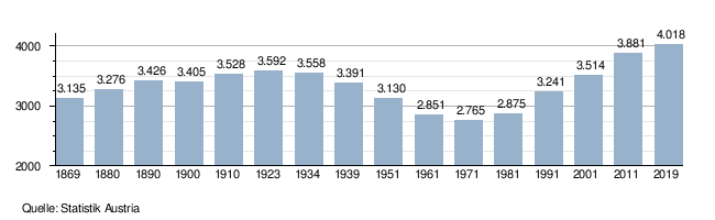
The migratory movement in the bacon belt around Vienna also increasingly reached the north of Vienna in the 1990s. If the birth balance in Harmannsdorf was negative for many years, there was overall strong growth in the population due to the strongly positive migration balance: Between 2001 and 2011, 360 more people moved to Harmannsdorf than from Harmannsdorf.
In 1991 there were 920 families, in 2001 there were already 1052 families in the Harmannsdorf community. In 1991 there were 1,525 buildings in the municipality, by 2001 the number of buildings rose to 1,720.
politics
The municipal council has 23 members.
- With the municipal council elections in Lower Austria in 1990, the municipal council had the following distribution: 14 ÖVP, 6 SPÖ and 3 FPÖ.
- With the municipal council elections in Lower Austria in 1995, the municipal council had the following distribution: 12 ÖVP, 7 SPÖ and 4 FPÖ.
- With the municipal council elections in Lower Austria in 2000, the municipal council had the following distribution: 14 ÖVP, 7 SPÖ and 2 FPÖ.
- With the municipal council elections in Lower Austria in 2005 , the municipal council had the following distribution: 14 ÖVP, 8 SPÖ and 1 FPÖ.
- With the municipal elections in Lower Austria in 2010 , the municipal council had the following distribution: 13 ÖVP, 7 SPÖ and 3 FPÖ.
- With the municipal council elections in Lower Austria in 2015 , the municipal council had the following distribution: 12 ÖVP, 4 SPÖ, 4 FPÖ, 2 7 places citizens list and 1 Greens.
- With the municipal council elections in Lower Austria 2020 , the municipal council has the following distribution: 12 ÖVP, 5 SPÖ, 2 FPÖ, 2 7 places citizens list and 2 Greens.
- mayor
- until 2009 Leopold Steindl (ÖVP)
- since 2009 Norbert Hendler (ÖVP)
Culture and sights
_-_Kirche_(1).JPG)

.JPG)


See also: List of cellar lanes in Harmannsdorf
- The parish church Harmannsdorf in Rückersdorf is mentioned in documents in 1282 and 1285. An older Romanesque nave building (7.9 x 15.8 m) has been partially preserved. On the occasion of the interior renovation in 1978, the Romanesque foundations of the church were exposed, which, according to estimates, were built in 1217 at the latest. In 1689 the church was redesigned in baroque styles , with the exception of the chancel and the Gothic chapel on the south side .
- The parish church of Obergänserndorf was only built in 1813 after the parish was founded in 1784. The current pastor is Stanislaw Zawila.
- The Würnitz parish church was built in 1971 according to plans by the architect Erwin Plevan , including the church tower from the previous building.
- The Kleinrötz branch church was built in 1907, renovated in 1927 and rebuilt from 1968 to 1971.
- Generation bridge (Rückersdorf): The generation bridge is a wooden bridge built at the turn of the millennium over the Danube trench in Rückersdorf. On the arches of the bridge are 76 plaques with the names of the 1,244 residents who to date have been resident on January 1, 2001 Harmannsdorf-Rückersdorf. The names on the metal boards are arranged according to the year of birth. In addition to the turn of the millennium, the generation bridge is also intended to express the bond between the older generations and the youth.
- Front memorial stone (Rückersdorf): The front memorial stone on Waldstrasse from Rückersdorf to Oberrohrbach at Landesstraße 32 is located where the front ran from April 17th to May 8th 1945 at the end of the Second World War and is also intended for future generations to remember the terrible days of the front recall.
- Kunstfeld Hetzmannsdorf: The Kunstfeld belongs to the Land Art art movement and is located right next to Laaer Straße near the village of Hetzmannsdorf. Between 2003 and 2005, eleven stone steles were set up at regular intervals on a wavy strip of land that is characteristic of the Weinviertel. The twelfth stele completes the dozen and is located on the outskirts of Harmannsdorf-Rückersdorf, also next to Laaer Straße. The granite stone blocks weighing 8-9 tons are about 4.50 m high, their cross-section is a square with 80 cm sides. The art field should lead to an examination of the cultural landscape in the Weinviertel. But it should also point to the work of the farmers, to the people who shape this landscape year after year and surround it with colors and structures, because they are inseparable co-creators in the necessary totality. Depending on the seasons, weather, day and night, the result is a constantly changing landscape, which is particularly emphasized by the line of sculptures.
- Sun wheel (Hetzmannsdorf): The sun wheel is also right next to Laaer Straße near the village of Hetzmannsdorf, not far from the Hetzmannsdorf art field. The yellow-orange painted wheel by artist Gerhard Kohlbauer from Bruderndorf has a height of about 5.5 meters, a width of about one meter and a weight of 2,500 kg. As a symbol for sun, light, space and movement, it should lead to an examination of the surroundings and the landscape. Through the encounter in public space, art is shifted to the public and can be seen by many people.
- Schwedenhöhlen (Rohrwald, west of Harmannsdorf): A legend tells that these holes in the ground were built in the 17th century as hiding places for the residents of the surrounding villages, shortly before the Swedish general Torstenson occupied the town of Korneuburg. Some of the caves are still accessible.
economy
There were 83 non-agricultural workplaces in 1991
and 113 in 2001. According to the 1995 survey, there were 139 in agriculture and forestry, and 123 in 1999.
The number of people in employment at home was 1528 in 1991, 1630 according to the 2001 census. The employment rate was 1999 at 48.78, in 2001 at 48.55 percent.
traffic
Rückersdorf-Harmannsdorf is on Laaer Strasse (B6 federal road), on which an average of over 10,000 vehicles per day ( DTVw ) drive on working days . A further increase in traffic to around 13,000 vehicles / day by 2020 is expected for the future. The population of Harmannsdorf-Rückersdorf and Tresdorf therefore called for a detour. More than 1,300 signatures were collected together for the rapid implementation of the planned bypass of the two towns and handed over to Governor Erwin Pröll . The route of the bypass was declared a state road planning area by ordinance in 2009. This bypass should not only reduce through traffic in these localities, but also traffic in Stetten and Seebarn after the completion of the S1 . The submission project was completed at the end of September 2012. Governor Erwin Pröll gave the official go-ahead for the construction of the bypass road on February 21, 2013. The start of construction on the six-kilometer bypass is scheduled for the end of 2020.
The connection to the public transport network is provided by an ÖBB bus line and a Dr. Richard bus line, both of which lead to Korneuburg station. However, this connection is almost not used by commuters due to the sometimes large intervals and the early closing time. Until 1988, the community had the Rückersdorf-Harmannsdorf station on the Korneuburg-Hohenau local railway .
education

There are two schools in Harmannsdorf. A primary school that is built right next to the middle school (formerly Josef Robl Hauptschule).
In the autumn of 1968 the construction of the Josef Robl secondary school in Harmannsdorf began. As early as the 1969/70 school year, lessons were started with two first classes, with the two classes initially being taught in the elementary school and in the municipality's meeting room. In January 1970 the classes temporarily moved to the new main school building, which was opened by Governor Andreas Maurer on August 30, 1970 after barely one and a half years of construction .
Due to an acute shortage of space, the first negotiations for a new primary school next to the secondary school took place on May 14, 1987. The ground-breaking ceremony took place on June 26, 1988 and finally the new elementary school opened on June 24, 1990.
In 2002 the secondary school was enlarged and redesigned. In 2013/2014 the school was converted to the Neue NÖ Mittelschule. Between 2008 and 2010 the school building got a new roof and was thermally renovated. There is also a day care center for compulsory school children, which was previously run by the Harmannsdorf day care center since 1998 and is now looked after by the “Lower Austria Family Region”. Since the 2019/20 school year, the "New Middle School" has been renamed middle school again and a new assessment system has been introduced.
The kindergarten in Harmannsdorf was opened in 1940 as a harvest kindergarten, at that time still at Laaerstraße 46 in the Minnich house. Later it was moved to Ringgasse 28 and from 1943 it was run as a permanent kindergarten at Kirchenplatz 10. In 1957 the newly built kindergarten was opened in the Kirchengasse in the former parish garden. After the construction of the elementary school next to the secondary school and its opening on June 24, 1990, the Rückersdorf kindergarten moved to the old elementary school next to the church. The former kindergarten in Kirchengasse has since been used by the community doctor Kurt Reif. In September 2016, the Rückersdorfer Kindergarten moved to the newly built kindergarten next to the new Lower Austrian Middle School.
Thus there are now three kindergartens in the market town of Harmannsdorf, in Obergänserndorf, in Rückersdorf and, since 2010, in Würnitz.
health
As the first community doctor in Harmannsdorf, Dr. Christoph Pein appointed. Since 1987 Dr. Kurt Reif and Dr. Ingrid Eva Reif was entrusted with the agendas of the community doctor. The dentist Dr. Palman opened his practice in 1991 in Rückersdorf.
Sports
Union Harmannsdorf is the leading sports club in Harmannsdorf. The club was founded in 1972 and now offers its members numerous sports. For this purpose, the gym of the elementary school, the sports hall and the sports field of the secondary school and the specially built tennis court are used.
There are two football clubs in the community that play in different regional leagues, FC Würnitz and TSU NeuMed Obergänserndorf.
Personalities
- The musician Paul Fields was born here in 1943.
- Josef Robl (former President of the Lower Austrian Parliament), Pastor Edwin Weninger, former mayor Johann Neumeyer and former mayor Leopold Steindl were named honorary citizens of the market town of Harmannsdorf .
- The former mayor Leopold Steindl, AltGfGR Johann Hendler, AltVizebgm are the bearers of the market town's golden ring of honor. Josef Maisser and AltGfGR Herbert Ulrich. Michael Keller, Johann Nägerl and Leopold Neumayer were among the winners of the silver ring of honor.
- Former Mayor Leopold Steindl was awarded the gold medal of merit of the Republic of Austria on March 1, 2011 .
Web links
- 31207 - Harmannsdorf (Lower Austria). Community data, Statistics Austria .
- Website of the market town of Harmannsdorf
Individual evidence
- ↑ Statistics Austria: Population on January 1st, 2020 by locality (area status on January 1st, 2020) , ( CSV )
- ↑ a b c d Heimatbuch Harmannsdorf-Rückersdorf, compiled by Pastor Rudolf Neumayer
- ↑ "The last battles of World War II" by Friedrich Brettner
- ^ Kurier, move to the Vienna area. March 25, 2018, accessed February 8, 2019 .
- ↑ Statistics Austria, A look at the community Harmannsdorf, population development. Retrieved February 8, 2019 .
- ↑ Statistics Austria
- ^ Result of the local council election 1995 in Harmannsdorf. Office of the Lower Austrian State Government, March 30, 2000, accessed on February 3, 2020 .
- ^ Election result of the municipal council election 2000 in Harmannsdorf. Office of the Lower Austrian State Government, February 4, 2005, accessed on February 3, 2020 .
- ^ Election result of the local council election 2005 in Harmannsdorf. Office of the Lower Austrian State Government, March 4, 2005, accessed on February 3, 2020 .
- ^ Election result of the municipal council election 2010 in Harmannsdorf. Office of the Lower Austrian State Government, October 8, 2010, accessed on February 3, 2020 .
- ^ Election results for the 2015 municipal council election in Harmannsdorf. Office of the Lower Austrian State Government, December 1, 2015, accessed on February 3, 2020 .
- ↑ Results of the municipal council election 2020 in Harmannsdorf. Office of the Lower Austrian State Government, January 26, 2020, accessed on February 3, 2020 .
- ↑ Mayor Norbert Hendler on the market town's website
- ^ Official homepage of the market town Harmannsdorf: Schwedenhöhlen. Retrieved July 2, 2020 (Austrian German).
- ↑ State of Lower Austria ( Memento of the original from March 4, 2016 in the Internet Archive ) Info: The archive link was inserted automatically and has not yet been checked. Please check the original and archive link according to the instructions and then remove this notice.
- ↑ Traffic investigation by arealConsult
- ↑ Traffic forecast B6 bypass company ArealConsult
- ↑ noel.gv.at press service of the state of Lower Austria, accessed on November 14, 2018
- ↑ 01 10 2018 at 11:54: Minister on New Middle School: "I believe in this ... Retrieved October 1, 2019 .
- ↑ Dr. Ingrid Eva Reif - 2111 Rückersdorf-Harmannsdorf. Retrieved July 2, 2020 .
- ↑ Official homepage of the market community Harmannsdorf: Harmannsdorf. Retrieved July 2, 2020 (Austrian German).
- ↑ harmannsdorf.gv.at (PDF; 442 kB)

Bisamberg | Enzersfeld in the Weinviertel | Ernstbrunn | Gerasdorf near Vienna | Großmugl | Großrußbach | Hagenbrunn | Harmannsdorf | Hausleiten | Korneuburg | Langenzersdorf | Leitzersdorf | Leobendorf | Niederhollabrunn | Russbach | Sierndorf | Spilling | Stetteldorf am Wagram | Stetten | Stockerau
Cadastral communities: Hetzmannsdorf | Kleinrötz | Mollmannsdorf | Obergänserndorf | Rückersdorf | Seebarn | Würnitz
Locations: Harmannsdorf | Hetzmannsdorf | Kleinrötz | Lerchenau | Mollmannsdorf | Obergänserndorf | Rückersdorf | Seebarn | Würnitz
Market place: Harmannsdorf | Villages: Hetzmannsdorf | Kleinrötz | Lerchenau | Mollmannsdorf | Obergänserndorf | Rückersdorf | Seebarn | Würnitz group of houses: Rückersdorf-Harmannsdorf-Bahnstation | Other locations: Wilczek Castle
Counting district: Harmannsdorf | Obergänserndorf | Hetzmannsdorf | Mollmannsdorf | Kleinrötz | Seebarn | Würnitz