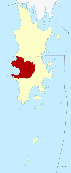
Amphoe Kathu
|
Kathu กะทู้ |
|
|---|---|
| Province: | Phuket |
| Surface: | 67.09 km² |
| Residents: | 50,558 (2012) |
| Population density : | 6016 E./km² |
| ZIP : | 83120, 83150 |
| Geocode : | 8302 |
| map | |

|
|
Amphoe Kathu ( Thai อำเภอ กะทู้ ) is a district ( Amphoe - Administrative District) in the Province of Phuket . The province of Phuket is located in the southern region of Thailand .
geography
Neighboring districts are: Amphoe Thalang in the north and Mueang Phuket in the west and south. The coast to the Andaman Sea lies in the west.
The most famous and largest tourist beach in Phuket is in the Kathu district: Patong . To the north is Kamala, which is far less developed in terms of tourist infrastructure.
history
On December 5, 1938, Kathu County was downgraded to a subdistrict ( King Amphoe ) and was also subordinated to Amphoe Mueang Phuket . On December 10, 1959, Kathu was restored to full amphoe status.
education
The sub-campus Phuket of the Prince of Songkla University is located in Amphoe Kathu .
administration
Provincial Administration
The district has three communes ( tambon ) , which in turn are divided into 14 villages ( muban ) .
|
Local administration
There are two towns ( Thesaban Mueang ) in the county:
- Patong ( เทศบาล เมือง ป่า ตอง ) consists of the whole tambon Patong.
- Kathu ( เทศบาล เมือง กะทู้ ) consists of the whole tambon Kathu.
Tambon Kamala is administered by a "Tambon Administration Organization" (TAO, องค์การ บริหาร ส่วน ตำบล ).
Individual evidence
- ↑ ประกาศ สำนัก นายกรัฐมนตรี เรื่อง ยุบ อำเภอ กะทู้ ลง เป็น กิ่ง อำเภอ . In: Royal Gazette . 55, No. 0 ง , December 5, 1938, p. 2966.
- ↑ พระราชกฤษฎีกา ตั้ง อำเภอ ชุมพวง อำเภอ เชียงยืน อำเภอ แก้ง ค ร้ อ อำเภอ สำโรงทาบ อำเภอ คอน สาร อำเภอ เซกา อำเภอ ทุ่งเสลี่ยม อำเภอ บ้าน ด่าน ด่าน อำเภอ ขนอม อำเภอ บ้านแพรก อำเภอ กระทู้ และ อำเภอ คลองใหญ่ พ.ศ. ๒๕๐๒ . In: Royal Gazette . 76, No. 113 ก ฉบับ พิเศษ (special), December 10, 1959, pp. 8-11.
- ↑ Population statistics 2012 . Department of Provincial Administration. Retrieved July 11, 2014.
Web links
Coordinates: 7 ° 55 ' N , 98 ° 20' E
