
Weather (river)
| Weather | ||
 course |
||
| Data | ||
| Water code | EN : 2484 | |
| location | Hessen , Germany | |
| River system | Rhine | |
| Drain over | Nidda → Main → Rhine → North Sea | |
| source | Between Laubach and Schotten ( Vogelsberg ) 50 ° 32 ′ 16 ″ N , 9 ° 5 ′ 7 ″ E |
|
| Source height | approx. 400 m above sea level NN | |
| muzzle | At Niddatal- Assenheim in the Nidda coordinates: 50 ° 17 ′ 52 " N , 8 ° 48 ′ 42" E 50 ° 17 ′ 52 " N , 8 ° 48 ′ 42" E |
|
| Mouth height | approx. 120 m above sea level NN | |
| Height difference | approx. 280 m | |
| Bottom slope | approx. 4.1 ‰ | |
| length | 68.8 km | |
| Catchment area | 516.989 km² | |
| Discharge at the Bruchenbrücken gauge 99.3% of the catchment area |
MQ |
2,993.9 m³ / s |
| Medium-sized cities | Bad Nauheim , Friedberg (Hesse) | |
| Small towns | Laubach , Lich , Niddatal | |
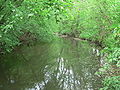
 The weather at Bad Nauheim-Steinfurth |
||
The Wetter is an almost 69 km long right tributary of the Nidda in Hesse .
course
The weather rises at the edge of the Vogelsberg between Laubach and Scots at the deserted village Sorgenlos flows through Lich in Gießen district and flows Niddatal - Assenheim in Wetteraukreis in the Nidda.
Dates and character
The Wetter, whose catchment area covers approx. 517 km², gives its name to both the Wetterau landscape and the Wetteraukreis district. At its tributaries include the United States .
Like most rivers in the Wetterau, it was straightened and deepened in the past in order to combat the risk of flooding, which today has proven to have the opposite effect.
Due to the large number of sewage treatment plants, the weather in summer shows a relatively constant water level compared to other bodies of water of the same size. The water quality therefore only fluctuates between levels II and III.
Entertains
The water association NIDDA, based in Friedberg (Hesse), is responsible for maintaining the weather between the Münster / Ober-Bessingen district boundary and the mouth of the river in the Nidda . The association also operates the large flood retention basin above the city of Lich .
The weather at Lich

Bridge over the Wetter in Arnsburg Monastery

A water wheel at the Wetter near Bad Nauheim-Schwalheim

at Dorheim

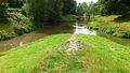
The weather in Niddatal-Assenheim shortly before it flows into the Nidda
The Wetter (right) flows into the Nidda


Tributaries
The tributaries of the Wetter include (viewed downstream, kilometers from the mouth to the source):
| Surname | GKZ | Length (km) |
Mouth height (m above sea level ) |
Direction of flow |
Junction at km (coordinates) | Mouth | Remarks |
|---|---|---|---|---|---|---|---|
| Heegbrückerbach | 2484116000 | 3.2 | 249 | Left | 64.0 ( ⊙ ) | Laubach | |
| Hirtenbach | 2484120000 | 2.7 | 212 | right | 61.2 ( ⊙ ) | Laubach | |
| Laubach | 2484132000 | 4.0 | 196 | right | 59.1 ( ⊙ ) | Laubach | |
| volume up | 2484140000 | 7.0 | 191 | right | 56.8 ( ⊙ ) | Laubach- Wetterfeld | |
| Äschersbach | 2484200000 | 13.6 | 182 | right | 54.0 ( ⊙ ) | Laubach- Munster | |
| Wellers grave | 248433182 | 2.4 | right | a tributary of the Wetter flows into the old brook | |||
| Riedgraben | 2484331400 | 4.4 | 172 | Left | 51.4 ( ⊙ ) | Lich - Nieder-Bessingen | |
| Old brook | 2484331800 | 2.3 | 171 | right | 49.8 ( ⊙ ) | Lich-Nieder-Bessingen | |
| Albach | 2484360000 | 6.8 | 169 | right | 46.0 ( ⊙ ) | Lich | |
| Pasture ditch | 2484380000 | 5.6 | 167 | Left | 45.5 ( ⊙ ) | Lich | |
| Mengelhauser Graben | 2484391620 | 2.3 | 166 | right | 43.3 ( ⊙ ) | Lich | |
| Petersgraben | 2484391800 | 4.9 | 161 | right | 41.8 ( ⊙ ) | Lich monastery in Arnsburg | |
| Welsbach (+ Rostgraben) |
2484400000 | 5.4 | 157 | right | 39.4 ( ⊙ ) | Lich- Muschenheim | The Rostgraben is often seen only as a secondary name for W. |
| Dig | 2484511600 | 2.9 | 153 | Left | 37.6 ( ⊙ ) | Lich-Muschenheim | |
| Wehdgraben | 2484519182 | 1.0 | 151 | Left | 33.9 ( ⊙ ) | Munzenberg | Opens into the Hechtgraben (tributary of the Wetter ) |
| Standing ditch | 2484519184 | 1.1 | 150 | Left | 33.3 ( ⊙ ) | Munzenberg | Opens into the Hechtgraben (tributary of the Wetter ) |
| Brunnenwiesengraben | 2484519188 | 0.6 | 150 | Left | 32.9 ( ⊙ ) | Munzenberg | Opens into the Hechtgraben (tributary of the Wetter ) |
| Gambach | 2484520000 | 5.5 | 150 | right | 30.2 ( ⊙ ) | Munzenberg- Gambach | |
| Bockenheimer Bach | 2484531400 | 4.5 | 150 | right | 29.4 ( ⊙ ) | Munzenberg-Gambach | |
| Kleinbach | 2484539140 | 5.9 | 149 | right | 26.9 ( ⊙ ) | Butzbach - Griedel | |
| Schorbach | 2484540000 | 2.3 | 145 | right | 25.0 ( ⊙ ) | Butzbach-Griedel | |
| Mutton houses ditch | 2484599200 | 4.5 | 141 | Left | 23.5 ( ⊙ ) | Rockenberg | |
| Riedgraben | 2484600000 | 8.8 | 140 | right | 22.0 ( ⊙ ) | Rockenberg- Oppershofen | |
| Riedgraben | 2484732000 | 0.9 | 139 | Left | 17.8 ( ⊙ ) | Bad Nauheim - Steinfurth | |
| Kröthentalgraben | 2484752000 | 2.1 | 136 | Left | 16.2 ( ⊙ ) | Bad Nauheim- Wisselsheim |
|
| Hechtgraben | 2484794000 | 1.5 | 126 | Left | 08.0 ( ⊙ ) | Friedberg - Dorheim | |
| United States | 2484800000 | 34.0 | 124 | right | 03.9 ( ⊙ ) | Friedberg- Fauerbach | |
| Strassbach | 2484920000 | 6.9 | 123 | right | 03.8 ( ⊙ ) | Friedberg-Fauerbach |
River system
Own river system
Nidda river system
Fish stocks
- Brown trout
- pike
- various white fish
Individual evidence
- ↑ a b Topographic map 1: 25,000
- ↑ a b c d WFD in Hesse
- ↑ Map of the Desert Carefree . Historical local dictionary for Hessen. In: Landesgeschichtliches Informationssystem Hessen (LAGIS).
- ↑ Topographic map 1: 25,000 and Google Earth
Web links
- Level near Münster on the HLUG side
- Level at Muschenheim on the HLUG side
- Level at rupture bridges on the HLUG side
- Low weather at Lich Natura 2000 Hessen
- Water profile and program of measures 2484.2 ( Memento from January 1, 2013 in the web archive archive.today ) ( Notes ) → Overview of all Hessian river systems (PDF, 1.7 MB) Upper weather
- Water profile and program of measures 2484.1 ( Memento from January 1, 2013 in the web archive archive.today ) ( Notes ) → Overview of all Hessian river systems (PDF, 1.7 MB) Untere Wetter