
List of rivers in the Nidda river system

The list of rivers in the Nidda river system includes all direct and indirect tributaries of the Nidda , provided that they are named on the property map or in the map service system of the Hessian State Office for Nature Conservation, Environment and Geology (HLNUG) WFD in Hesse . Other source works are documented separately in the individual references. If the river name changes after the confluence of two river sections, the two tributaries are listed separately as source tributaries, otherwise the sub-area name appears in brackets. Nameless inlets and branches are not taken into account. The length specifications are rounded to one decimal place. The rivers are listed downstream. The orographic directional information refers to the directly superior body of water. Partial river systems with more than 20 rivers are outsourced to a separate list (→ river system).
Nidda
The Nidda is a 89.7 km long right tributary of the Main in Hesse .
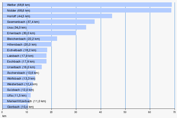
Rivers greater than 10 km
Tributaries

_06.JPG)
- Direct and indirect tributaries of the Nidda
- Graswiesenbach ( Streitbach ) ( right ), 4.0 km, 3.73 km², 68.3 l / s, in Schotten - Rudingshain , 423 m above sea level. NHN
- Hohlbach ( right ), 3.4 km, on the northeast edge of Schotten, 330 m above sea level. NHN
- Michelbach ( left ), 5.3 km, 5.80 km², 81.2 l / s, south of Schotten, 254 m above sea level. NHN
- Läunsbach ( left ), 5.4 km, 5.83 km², 59.2 l / s, north of Schotten- Rainrod , 239 m above sea level. NHN
-
Gierbach ( right ), 6.4 miles
- Stückbach ( right ) 3.1 km
- Weißbach ( left ), 1.8 km
-
Eichelbach ( left ), 18.2 km
- Eckardsbach ( Waidbach ) ( left ), 6.5 km
- Schandwiesenbach ( left ), 3.5 km
-
Ulfa ( right ), 11.5 km
- Greinbach ( left ), 1.9 km
- Kalter Grund ( left ), 3.6 km
- Diebach ( right ), 1.5 km
-
Hohensteinerbach ( left ), 4.2 km (with Haißbach 6.4 km)
- Haißbach ( right source stream ), 2.2 km
- Buchborngraben ( left source stream ), 2.5 km
- Mörschbach ( right ), 0.7 km
- Liebholzgraben [GKZ 248151828] ( left ), 0.6 km
- Salzbach ( right ), 3.6 km
- Hollergraben ( right ), 1.6 km
-
Laisbach ( left ), 11 miles
- Krummbach (right) 4.1 km, 3.9 km²
- Bermegrundgraben ( right ), 0.4 miles
- Heggraben ( right ), 0.7 km
- Fauerbacher Bach ( right ), 2.7 km, 3.2 km²
- Rambach ( Niddaer Bach ) ( right ), 7.8 km
- Krummbach (right) 4.1 km, 3.9 km²
- Heggraben ( right ), 2.0 km
-
Wehrbach ( left ), 4.0 km
- Mud trap ( left ), 2.0 km
- Wörthbach (left), 1.8 miles
- Pohlheimer Bach ( left ), 2.5 km

- Horloff ( right ), 44.5 km → river system
- Rossriedgraben ( right ), 1.2 km
- Teufelsgraben ( right ), 1.5 miles
- Sternbach ( left ), 2.3 km
- Mühlbach ( left ), 1.5 miles

- Weather ( right ), 68.8 km → river system
- Notbach ( left ), 2.3 km
-
Rosbach ( Gänsbach , Aubach ) ( right ), 8.2 km (with Aubach 9.0 km)
- Aubach ( left source stream ) 0.8 km
- Fahrenbach ( right source stream ), 4.7 km
- Lachengraben ( right ), 1.4 km
- Ilbenstädter Lohgraben ( left ), 2.2 km
- Weinbach ( Bürgelgraben ) ( right ), 4.1 km
- Beunbach ( right source stream ), 1.8 km
- Harbach ( left source stream ), 1.4 km
- Scheidgraben ( left ), 1.0 km
- Rollgraben ( left ), 1.2 km
- Mittelgraben ( right ), 1.8 km
- Heitzhoferbach ( right ), 3.8 km
- Riedgraben (left), 3.6 km
- Hamster pit ( left ), 4.7 km
- Lohgraben ( left ), 8.4 km
- Hamster pit ( left ), 4.7 km
- Riedgraben (left), 3.6 km

- Wiesenbachgraben ( left ), 2.5 km
- Geringsgraben ( Langgraben ) ( right ), 3.3 km
- Selzenbach ( left ), 2.0 km
- Weilachgraben ( right ), 5.0 km
- Nidder ( left ), 68.6 km → river system
- Mühlbach ( Eselborngraben ) ( left )
- Edelbach ( left ), 2.3 km
- Landgraben ( left ), 1.9 km


-
Erlenbach ( right ), 30.0 km
- Sommerbach (right), 2.0 km
- Mühlbach (right), 2.0 km
-
Bizzenbach ( Pissebach ) (left), 4.0 km
- Langwiesengraben ( right ), 1.8 km
- Farnbach ( left ), 2.3 km
-
Seulbach ( right ), 4.7 km
- Salb ( left ), 1.0 km (with Rehlingsbach 2.1 km)
- Rehlingsbach ( left source stream ), 1.1 km
- Schnepfenbach ( right source stream ), 0.4 miles
- Schäferborngraben (left), 1.5 miles
- Salb ( left ), 1.0 km (with Rehlingsbach 2.1 km)

-
Eschbach ( right ), 17.9 km
-
Kirdorfer Bach ( left source brook )
- Saalborn ( left ), 1.3 km
- Fahrborn ( left )
- Brook from the Röderwiesen ( right ), 1.3 km
- Tiefenbach ( left ) 1.8 km
-
Dornbach ( right source stream )
- Cold water ( left source stream )
- Stream from the gold mine ( Dornbachnebengraben ) ( right source stream )
- Lotzengrundbach ( right )
-
Heuchelbach ( left ) 4.3 km (with Hirschgraben 9.7 km)
- Stream from the Braumannswiesen ( left source stream ), 1.2 km
- Hirschgraben (GKZ 248924) ( right source stream ), 5.4 km
- Lohrbach ( right ), 3.5 km
- Taunengraben ( right ), 3.8 km
- Heinweidengraben ( right ) 2.7 km
- Well ditch ( left )
-
Kirdorfer Bach ( left source brook )

-
Kalbach ( right ), 5.3 km
- Kätcheslach ( right )
- Schwarze Kalbach ( left )
- Rohrborngraben ( right ), 1.0 km
- Lachegraben ( Oberwiesengraben ) ( left ), 3.0 km

-
Urselbach ( Haidtränkbach ) ( right ), 16.0 km
-
Maßborn ( left ), 2.7 km
- Dreiborn ( right )
- Hermannsborn ( left ), 1.0 km
- Kauteborn ( left ), 0.4 miles
- Hans-Wagner-Born (left), 1.6 km
- Buchborn ( left ), 0.6 km
- Schelbach ( left ), 1.5 km
- Maasgrundbach ( right ), 1.9 km
-
Stierstädter Bach ( Altbach ) ( right ) 3.3 km
- Edel River ( left ), 0.6 km
-
Maßborn ( left ), 2.7 km

-
Steinbach ( right ), 4.6 km
- Wooggraben ( left )
- Ox pit
- Wooggraben ( left )
-
Westerbach ( right ), 10.6 km (with Schönberger Bach 12.4 km)
- Winkelbach ( right source stream ) 2.6 km
- Schönberger Bach ( left source brook ) 1.8 km
- Hohwiesenbach ( Waldwiesenbach ) ( left ) 3.4 km
- Stuhlbergbach ( left ), 5.4 km
- Laufgraben ( Dottenfeldgraben ) ( right ), 2.4 km
2008_0504.JPG)
-
Sulzbach ( right ), 12.0 km
- Kahlbach ( right ) 0.9 km
- Mailborn ( right ), 0.9 km, near Bad Soden
- Niederdorfsbach ( main ditch ) ( left ) 2.0 km
-
Schwalbach ( left ) 7.20 km
- Waldbach ( right source stream ), 5.1 km
- Sauerbornsbach ( left source stream ), 5.9 km (with Badbach 7.2 km)
Individual evidence
- ↑ Name for middle course
- ↑ Name for the lower course (and the upper course)
- ↑ Also regarded as the name of the upper reaches
- ↑ Also viewed as a tributary
- ↑ Name of the main estuary, another estuary is the Breitwiesengraben
- ↑ with the nameless body of water 248596
- ^ Name of the upper course near Frankfurt city water
- ^ Ak Mobility and Transport, Agenda 21, Bad Homburg
- ↑ a b c d e f g h Urselbacher Bächer , Bund für Umwelt und Naturschutz eV, local association Oberursel / Steinbach, June 2006
- ↑ a b c Name at Stadtgewässer Frankfurt
- ↑ Upper course