Hypocrisy
| Hypocrisy | ||
|
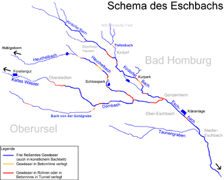
Scheme drawing of Heuchelbach and Eschbach |
||
| Data | ||
| Water code | DE : 248924 | |
| location |
Taunus
|
|
| River system | Rhine | |
| Drain over | Dornbach → Eschbach → Nidda → Main → Rhine → North Sea | |
| source |
Habigsborn below the Roman fort Heidenstock 50 ° 15 ′ 3 ″ N , 8 ° 31 ′ 24 ″ E |
|
| Source height | approx. 485 m above sea level NHN | |
| muzzle | in the urban area of Bad Homburg vor der Höhe in the Dornbach Coordinates: 50 ° 13 ′ 15 ″ N , 8 ° 37 ′ 36 ″ E 50 ° 13 ′ 15 ″ N , 8 ° 37 ′ 36 ″ E |
|
| Mouth height | approx. 170 m above sea level NHN | |
| Height difference | approx. 315 m | |
| Bottom slope | approx. 33 ‰ | |
| length | 9.5 km | |
| Catchment area | 61.43 km² | |
| Discharge A Eo : 61.43 km² at the mouth |
MQ Mq |
76.8 l / s 1.3 l / (s km²) |
| Medium-sized cities | Bad Homburg vor der Höhe | |
|
The Heuchelbach in the Hirschgarten |
||
The Heuchelbach is the approximately 10 km long central spring stream of the Eschbach . Historically, the Heuchelbach has had many names on parts of it (Herzbach, Hirschbach, Eschbach, Altbach and others). Because of its length, the largest catchment area, formerly strongest water flow and the historical names, the stream is considered the actual upper reaches of the Eschbach.
geography
course
The source of the Heuchelbach, the Habigsborn , is 490 m above sea level on the northern slope of the Kellerberg (Taunus). There is a sign with the inscription "Eschbachquelle" on a tree of clubs. Higher source areas, as indicated on the geological map, are no longer pronounced today. Soon below the Habigsborn, the brook often runs out of water every year, because the fissure groundwater is drawn off through the lower Elisabethen tunnel for drinking water. So is the In 420-460 m above sea level. NN located Keller Born , formerly a key source zone of Heuchelbaches, today significantly dried and primarily with Moorgrass existed as Seasonally wet hands. The Kellerborn goes back to the layer boundary of the more fractured Taunus quartzite over the less permeable Hermes sandstone .
Spruce trees dominate the valley floor . For a low mountain range the larches are common on the valley slopes. On the summit of the nearby Bleibeskopf ( 480 m above sea level) there are still stands of a sessile oak forest and a ring wall .
Coming from Herzberg , a small creek with no name flows from the left. At the Elisabethenstein , a quartzite rock at 310 m above sea level. NN, the main sources of the Heuchelbach are today at the layer boundary between quartzite and the underlying, denser green slate. They carry water all year round.
The Elisabethenschneise was built in 1821 . For this purpose, the Leopoldsbrücke had to be built over the Heuchelbach. The architect was the court mason Johann Weckerling. The inscription in the zenith of the barrel vault reads: “FRIEDRICH JOSEPH Sv. LANDGRAF ZHHOMBURG d 15t N 1823 ".
The Heuchelbach (Hirschbach) passes the Hirschgarten , the upper part of the now restored landgrave gardens and ponds , the Erlenhof and the bush meadows (leisure area). In Dornholzhausen the brook takes the brook from the Braumannswiesen from the left.
In summers with little rain, the Heuchelbach often falls dry on the following stretch through the city of Bad Homburg vor der Höhe , because, among other things, it no longer has any noteworthy source inflows. In addition, there is often the possibility of creek water seeping into deep-lying canal beds when there is a flow of places. After a passage through the castle park with the confluence of the Lohrbach (coming on the right from Oberstedten) the Heuchelbach flows together before Gonzenheim with the Dornbach coming from Oberstedten within the crossing under the Pappelallee. During the construction of the old Bad Homburg terminus station in 1860, the course was intervened between the castle park and the confluence and the stream was partially relocated during the construction of the new Usinger station in 1895. The following stretch to the confluence with the Kirdorfer Bach is now officially often named after the Dornbach.
Nidda river system
Literature and map
- Tobias, Bernerth in: Mitteilungen des Ver. F. History and local history Bad Homburg, 1993.
- Schuhmacher Thomas 1986/87: Expert opinion on alternatives to the planned flood retention basin of Nieder-Eschbach .
- Topographic map 1: 25,000, sheet 5717, Bad Homburg .
Individual evidence
- ↑ Topographic map 1: 25,000
- ↑ a b Map service for the implementation of the Water Framework Directive in Hesse ( Memento of the original from January 16, 2013 in the Internet Archive ) Info: The archive link was inserted automatically and has not yet been checked. Please check the original and archive link according to the instructions and then remove this notice.
- ↑ Water map service of the Hessian Ministry for the Environment, Climate Protection, Agriculture and Consumer Protection ( information )
- ^ State Office for the Preservation of Monuments Hesse (ed.): Bridges to Elisabethenschneise In: DenkXweb, online edition of cultural monuments in Hesse
- ↑ Site plan of the two old Bad Homburg train stations, district archive of the Hochtaunus district


