
Stay head
| Stay head | ||
|---|---|---|
| height | 480.1 m above sea level NHN | |
| location | near Dornholzhausen ; Hochtaunuskreis , Hessen ( Germany ) | |
| Mountains | Taunus | |
| Dominance | 0.45 km | |
| Notch height | 15 m | |
| Coordinates | 50 ° 14 '48 " N , 8 ° 32' 16" E | |
|
||
| particularities | Ringwall Bleibeskopf | |


The Bleibeskopf , formerly Bleibiskopf called, is a 480.1 m above sea level. NHN high spur of the Roßkopf (approx. 635 m ) in the Taunus . It is located near Dornholzhausen in the Hessian Hochtaunuskreis . The Bleibeskopf ring wall is located on the spur .
geography
location
The Bleibeskopf rises in the Taunus Nature Park . Be in-the district Dornholzhausen peak is 3.5 km west-northwest of Dornholzhausen, a district of Bad Homburg , 3.4 km northwest of Oberstedten , such of Oberursel , and 1.5 km south-southeast of the summit to Taunus main ridge belonging Roßkopfs. The north-northeast neighbor is another Roßkopfsporn with the Herzberg ( 591.4 m ).
On the south-eastern flank of the Bleibeskopf is the quartzite rock Elisabethenstein (formerly Eschbachstein ) at a height of about 315 m . Nearby is the Lepoldsbrücke, built in 1823 as a structure on the Elisabethenschneise forest path . It leads over the Heuchelbach coming from Habigsborn , which passes the spur to the southwest.
Natural allocation
The Bleibeskopf belongs to the natural spatial main unit group Taunus (No. 30) and in the main unit Hoher Taunus (301) to the subunit Feldberg-Taunuskamm (301.3). The landscape falls to the east into the subunit Homburger Vortaunus (300.3) and to the southeast into the natural area Kronberger Taunusfuß (300.21), which belongs to the subunit Altkönig Vorstufe (300.2), and which each belong to the main unit Vortaunus (300).
Ringwall Bleibeskopf
→ Main article: Ringwall Bleibeskopf
In the late Bronze Age (around 800 BC) there was a pre-Celtic hilltop settlement of the Urnfield culture on the Bleibeskopf . This ring wall is the oldest in the Taunus . The ring wall , once about 3 to 3.5 m wide, 1.8 m high and 490 m long, can still be seen today. Two rock groups were integrated into the wall. The entrance was a simple break in the wall, not a pincer gate. The settlement area has an area of around 1.4 hectares and is divided into three plateaus of different heights. Numerous bronze objects were found on the spur: a spout ax , an ornate lance tip, a knife, a needle, a razor, and leg rings with counters on the inside. These counters are among the oldest in Europe north of the Alps.
Excavations
At the beginning of the 20th century, the Frankfurt architect CL Thomas carried out systematic excavations on the Bleibeskopf. The finds are exhibited in the museum of the Saalburg fort and in the Vortaunusmuseum in Oberursel .
gallery

Bleibeskopf, upper rock group

Stay head, look down on the lower plateau
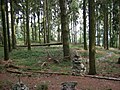
Bleibeskopf, view of the middle plateau
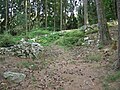
Bleibeskopf, view of the original entrance


See also
Individual evidence
- ↑ a b Map services of the Federal Agency for Nature Conservation ( information )
- ↑ Brigitte Schwenzer: Geographical land survey: The natural space units on sheet 139 Frankfurt a. M. Federal Institute for Regional Studies, Bad Godesberg 1967. → Online map (PDF; 4.9 MB)
literature
- Jörg Lindenthal: Cultural Discoveries. Archaeological monuments in Hessen. Jenior, Kassel 2004, p. 13 f, ISBN 3-934377-73-4
- Ferdinand Maier : The late Urnfield ring wall on the Bleibeskopf in the Taunus. Leaflet to the fortified hill settlement of the 8th century BC In the state forest Bad Homburg v. Chr. d. Höhe, Hochtaunuskreis. Wiesbaden 1983 ISBN 3-89822-027-3 ( Archaeological Monuments in Hesse 27 )
- Peter Titzmann: The Bleibeskopf im Taunus, a fortification at the turn of the Bronze Age to the Iron Age , in: Ingrid Berg (Hrsg.), "Heimat Hochtaunus", Frankfurt am Main 1988, ISBN 3-7829-0375-7 , p. 140 -145