
Ringwall Bleibeskopf
| Ringwall Bleibeskopf | ||
|---|---|---|
 The wall in the northwest area |
||
| Alternative name (s): | Ringwall lead head | |
| Creation time : | around 800 BC Chr. | |
| Castle type : | Hilltop castle | |
| Conservation status: | Burgstall, remains of a wall | |
| Place: | Bad Homburg vor der Höhe | |
| Geographical location | 50 ° 14 '48.3 " N , 8 ° 32' 17" E | |
| Height: | 480.1 m above sea level NN | |
|
||

The rampart Bleibeskopf is on the Bleibeskopf , one the Taunus ridge 1.5 km upstream hilltop. Based on the local find situation, it can be assigned to the urn field culture (around 800 BC).
Location and description
The Bleibeskopf ring wall is located about 6 km northwest of the city center of Bad Homburg vor der Höhe and 3.5 km southwest of the Saalburg . It is about 150 m lower than the ridge line of the Taunus in this area. It surrounds the top of the Bleibeskopf, which slopes steeply to the west, south and east in this area. Only in the north is there a flat transition that connects to the Roßkopf in the shape of a saddle . The complex is completely wooded.
The wall itself has a circumference of almost 500 m and encircles an area of 1.4 hectares. The system uses the existing terrain profile and thus integrates existing rock formations on the south-west side into the wall. There is a height difference of up to 25 m within the facility. As a result, the interior is essentially divided into three height levels. The highest level is the northern one. This is the most heavily developed part of the facility for defense purposes, which is due to the fact that the most vulnerable area of the facility is located here.
The second height level slopes to the south and is located in the western area of the wall. The third and thus lowest altitude level is in the east. The wall itself consisted of a 3.0 m wide dry stone wall . There is no trench, although this could only have been necessary in the north. A gate in the north allowed access to the complex.
In today's representation, local signs prompted people to build stone towers and other works of art with the stones lying around. Accordingly, there are many such decorations on the complex. Extensive sidewalks and walls are also marked with stone laying. However, these probably do not correspond to the historical representation.
exploration
Investigations on the Bleibeskopf ring wall were carried out by Christian Ludwig Thomas in 1899, 1909 and 1910 . The find situation allows typologically and chronologically a uniform overall picture and the corresponding dating to the time of the urn field culture. In addition, a purely one-period settlement seems to be assured. Seven deposits are of particular importance . The bronze objects found document a wide range of weapons, tools, jewelry and other equipment, with cast cakes indicating local workshops. The reason why the depots were created is unclear today. However, the finds underline the importance of the complex, which, according to the research results available, can be classified as a permanent hillside settlement.
Monument protection
The castle stable of the ramparts is a ground monument according to the Hessian Monument Protection Act . Investigations and targeted collection of finds are subject to approval, and accidental finds are reported to the monument authorities.
gallery

The author of this saying interprets the function of the wall based on the Lord of the Rings , but scientifically incorrect.

Decoration by means of a Celtic wheel
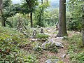
There are stone towers and works of art everywhere on the Bleibeskopf ring wall

Suggested course of the dry stone wall

View of Frankfurt am Main


literature
- Bavarian Land Survey Office Munich (Ed.): Topographical map. Federal Republic of Germany. TK 50th sheet: L 5717. Bad Homburg in front of the height. Normal edition, 7th edition, comprehensive update 1993. Bavarian State Surveying Office - State Office for Surveying and Geoinformation Bavaria, Munich 1995, ISBN 3-89446-203-5 .
- Fritz-Rudolf Herrmann , Albrecht Jockenhövel et al. (Hrsg.): The prehistory of Hesse. Konrad Theiss Verlag, Stuttgart 1990, ISBN 3-8062-0458-6 .
- Jörg Lindenthal: Cultural Discoveries. Archaeological monuments in Hessen. Jenior, Kassel 2004, ISBN 3-934377-73-4 , p. 13f.
- Ferdinand Maier : The late Urnfield ring wall on the Bleibeskopf in the Taunus. Leaflet to the fortified hill settlement of the 8th century BC In the state forest of Bad Homburg vd Höhe, Hochtaunuskreis (= Archaeological Monuments in Hesse 27, ISSN 0936-1693 ). Department for Prehistory and Early History in the State Office for Monument Preservation Hesse, Wiesbaden 1983 ISBN 3-89822-027-3 .
- Peter Titzmann: The Bleibiskopf in the Taunus, a fortification at the turn of the Bronze Age to the Iron Age. In: Ingrid Berg (Ed.): Heimat Hochtaunus. Kramer, Frankfurt am Main 1988, ISBN 3-7829-0375-7 , pp. 140-145.

Ringwall Altkönig | Altweilnau Castle | Bassenheimer Palais | Binzelberg Castle | Ringwall Bleibeskopf | Bommersheim Castle | Brendelburg | Drusenküppel Wehrheim | Eichelbacher Hof | Eichelberg Castle (Weilrod) | Emmershausen Castle | Falkenstein castle ruins | Ringwall Gickelsburg | Gothic house Bad Homburg | Friedrichshof Palace | Hattstein castle ruins | Homburg Castle | Ringwall Hünerberg | Königstein Castle | Kransberg Castle | Kronberg Castle | Neuweilnau Castle | Nürings Castle | Reifenberg Castle | Prinzenpalais Usingen | Ringwall rent wall | Schnepfenburg | Usinger Castle | Wingertsbergschlösschen Bad Homburg