
Eschbach (Nidda)
| Eschbach | ||
 Scheme drawing of the Eschbach and the source streams |
||
| Data | ||
| Water code | DE : 24892 | |
| location |
Taunus
|
|
| River system | Rhine | |
| Drain over | Nidda → Main → Rhine → North Sea | |
| Headwaters | various in the Taunus west of Bad Homburg | |
| muzzle | behind Frankfurt-Harheim in the Nidda coordinates: 50 ° 10 '52 " N , 8 ° 41' 53" E 50 ° 10 '52 " N , 8 ° 41' 53" E |
|
| Mouth height | approx. 105.5 m above sea level NHN
|
|
| Catchment area | 61.43 km² | |
| Drain at the mouth |
MQ |
428.9 l / s |
| Communities | Bad Homburg, Frankfurt | |
 The Eschbach in Ober-Eschbach |
||
The Eschbach is a brook in the state of Hesse in Germany . It rises east of the Großer Feldberg in the Taunus and flows into the Nidda from the right and from the north near Frankfurt-Harheim .
Names
The part of the name Esch can be traced back to Ascapah . Eschbach means the stream on which ash trees grow .
geography
course
The Eschbach does not have its own source . It arises from the confluence of several individual streams that arise above Bad Homburg in front of the Höhe or Oberursel . A scheme of the source streams:
- Eschbach
-
Kirdorfer Bach (source near the Saalburg )
- Tiefenbach
- Bach from the Röderwiesen
-
Heuchelbach (source Habigsborn 490 m above sea level)
- Bach from Herzberg
- Bach from the Braumannswiesen
- Lohrbach
-
Dornbach / Kaltes Wasser , spring southwest of the Kellerberg
- Bach von der Goldgrube (sources near Oberursel, often referred to as Dornbach on maps )
- Lotzengrundbach
-
Kirdorfer Bach (source near the Saalburg )
As a rule, the Heuchelbach is regarded as the longest and previously the most water-rich source brook and, for historical reasons, as the upper reaches of the Eschbach. Accordingly, there is a sign Eschbachquelle at its source in Habigsborn (490 m above sea level).
The Kirdorfer Bach artificially flows around the Jubilee Park and Kurpark in Bad Homburg and feeds the pond there. The Heuchelbach feeds the castle pond. The Dornbach hit the headlines in January 2003 when it overflowed its banks after heavy rainfall and flooded the Bad Homburg signal box , which paralyzed all traffic on the S5 railway line . Between Urseler Straße and the train station, the Dornbach, which runs in a concrete tunnel, is to be exposed again as part of the planned construction of an office park.
In the Bad Homburg districts of Ober-Eschbach and Gonzenheim , the streams unite to form the Eschbach. The only sewage treatment plant on the stream is on the outskirts . Especially in summer it brings the stream many times more water than it carries. After crossing under the A 5 , the stream reaches Frankfurt-Nieder-Eschbach . On the outskirts, the Taunengraben coming from Oberursel-Bommersheim flows here from the right. Its main source inflow is the Herrnweidgraben. The Mühlgraben that previously existed in Frankfurt-Nieder-Eschbach was drained in the course of renaturation work , the former weir was converted into a bed sill. After heavy rainfall, Frankfurt-Nieder-Eschbach is at risk of flooding due to the high degree of sealing in the Eschbach catchment area (Bad Homburg). Below Harheim the brook flows into the Nidda.
The Eschbach used to be of major economic importance within Bad Homburg. Probably as early as the 14th century, the Hubbach was diverted as a ditch from the Heuchelbach on Götzenmühlweg near a former effort that still exists today, led around the old town and led into the castle ponds. These served as reservoirs for the most important urban mills, the upper and lower mills. Water was also diverted from the Dornbach. Not far from the Platzenberg, where there were once 14 mills from Oberstedten, another canal began near the mouth of the brook from the gold mine , which led to the castle pond. For the operation of the saltworks and sod mill, where the Russian Chapel stands today, a tunnel was even dug from today's Hessenring under Luisenstraße through to the saltworks in the 17th century.
Nidda river system
Ecological
During the summer , the upper reaches of the Eschbach sometimes dry out or carry only minimal water. This applies in particular to the Heuchelbach and Kirdorfer Bach, in whose catchment area a lot of groundwater is extracted from the fissures in the rocks for drinking water. The Eschbach then only carries sufficient water below the sewage treatment plant. Most fish species therefore only occur after the sewage treatment plant. These are more robust species such as river loach , river perch or chub . Signal crabs also occur, surprisingly also in the shallow water in Ober-Eschbach. In the upper reaches of the creek Kirdorfer still find sticklebacks . Recently, small to medium-sized specimens of the brown trout have also been observed more frequently in the remaining areas of the Ober-Eschbach stream and in the Frankfurt area ( Nieder-Eschbach , Harheim ). In Harheim the stream is also fished by fly fishermen . At Kalten Wasser there is a commercial trout farm with an inn near Dornholzhausen near the deer garden, as the water here is still cool and clean. After the return, however, the water is polluted by the excretions of the many farmed fish.
Apart from the upper areas of the source rivers (level I), the Eschbach is in water quality level II, behind the sewage treatment plant then II-III.
When it rains heavily, large amounts of wastewater are quickly channeled into the stream through some rain overflows and rain overflow basins . For this reason, a large rain overflow basin is being built near the sewage treatment plant in order to reduce the polluted discharges.
The water structure quality is mostly very bad, however, as the streams have changed mainly in the Bad Homburg area (diversion around the spa park) and some have been laid in concrete channels or under tunnels (see scheme), which represents a maximum change.
Neophytes are sometimes very common. The Indian balsam can be found immediately below the trout estate. The Japanese knotweed has established itself in many places where the bank has been straightened. A population the size of a tennis court can be found near Dornholzhausen on the Kirdorfer Bach. It stands on the former garbage dump next to the golf course and “hiked down” the slope there. Due to the strong erosion in this area, it also finds its way down the stream. Since the landfill itself is now endangered by the stream, the stream should be relocated a few meters away from the slope.
photos
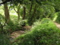
Natural site of the Kirdorfer Bach near Dornholzhausen

The Kirdorfer Bach flows around the Bad Homburg spa gardens in a channel

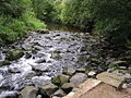
The cold water just before the trout farm

The Heuchelbach behind the "Hirschgarten"
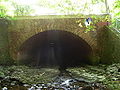
End of the Heuchelbach and Dornbach tunnels. The brooks flow together in the tunnel 50 m beforehand
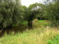
In the area of a renatured weir before Nieder-Eschbach

Artificial tour in Nieder-Eschbach
It flows into the Nidda near Frankfurt-Harheim


literature
- City of Frankfurt am Main, Environment Agency (Ed.): City waters - discover rivers, streams, oxbow lakes . Frankfurt 2004
Web links
- Hessian State Office for Environment and Geology , in the environmental atlas you can find information about the water quality
- Eschbach and Mühlgraben at par.frankfurt.de , the former website of the city of Frankfurt am Main
- GESIS (Gewässerstrukturgurgüteinfosystem) of the MULV Hessen, the Eschbach can be found under the code number 24892
- Retention cadastre Eschbach river basin Code number: 24892 (PDF file; 329 kB)
- Water profile and program of measures 24892.2 ( Memento from January 1, 2013 in the web archive archive.today ) ( Notes ) → Overview of all Hessian river systems (PDF, 1.7 MB) Upper Eschbach
- Water profile and program of measures 24892.1 ( Memento from January 1, 2013 in the web archive archive.today ) ( Notes ) → Overview of all Hessian river systems (PDF, 1.7 MB) Unterer Eschbach
Individual evidence
- ↑ a b Eschbach and Mühlgraben at frankfurt.de
- ↑ Water map service of the Hessian Ministry for the Environment, Climate Protection, Agriculture and Consumer Protection ( information )
- ↑ Water map service of the Hessian Ministry for the Environment, Climate Protection, Agriculture and Consumer Protection ( information )
- ↑ From WFD in Hesse is Dornbach than the upper reaches of the Eschbaches viewed
- ↑ 1000 jobs are created here ( page no longer available , search in web archives ) Info: The link was automatically marked as defective. Please check the link according to the instructions and then remove this notice. , Report of the Taunus-Zeitung from September 3, 2008
- ↑ On the subject: Homburgs Bächer , article in the Taunus newspaper from January 18, 2013
- ^ Frankfurter Fischereiverein von 1875 eV | Eschbach. Retrieved March 29, 2017 .
- ↑ Environmental Atlas Hessen → Water → Surface Waters → Biol. Water Quality