Kirdorfer Bach
|
Kirdorfer Bach Möhrenbach |
||
|
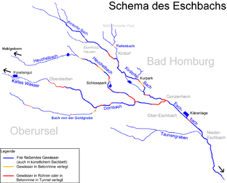
Scheme drawing of Heuchelbach and Eschbach |
||
| Data | ||
| Water code | DE : 248926 | |
| location |
Taunus
|
|
| River system | Rhine | |
| Drain over | Eschbach → Nidda → Main → Rhine → North Sea | |
| source | am Südwesthang of Emesberg 50 ° 15 '48 " N , 8 ° 33' 8" O |
|
| Source height | approx. 490 m above sea level NHN | |
| confluence | with the Dornbach to Eschbach in Bad Homburg - Gonzenheim Coordinates: 50 ° 13 '17 " N , 8 ° 38' 34" E 50 ° 13 '17 " N , 8 ° 38' 34" E |
|
| Mouth height | approx. 148 m above sea level NHN | |
| Height difference | approx. 342 m | |
| Bottom slope | approx. 38 ‰ | |
| length | 8.9 km | |
| Catchment area | 16.553 km² | |
| Discharge A Eo : 16.553 km² at the mouth |
MQ Mq |
49.3 l / s 3 l / (s km²) |
| Medium-sized cities | bad Homburg | |
|
Kirdorfer Bach at the "Jubilee Park" |
||
The Kirdorfer Bach is the almost nine kilometers long left and northeastern source brook of the Eschbach .
geography
Source area
The main source zone of the brook lies in the Taunus on the south-west exposed slope of the Emesberg at 420 and 490 m above sea level. NHN between Herzberg and Saalburg . The formerly most important spring is called the Nymphenquelle . Today the spring zone is subject to strong influences from drinking water extraction. To supply the city of Bad Homburg vor der Höhe with water, the Jungfernstollen was driven into the rock at the beginning of the 20th century , and down the valley the Saalburgstollen , which brings about 8 l / s of water. Correspondingly, fractured groundwater is drawn from the mountain and the upper reaches of the Kirdorfer Bach often falls dry.
Further course
Only in the further course at the layer boundary of quartzite to be underlying, poorly permeable rock in approx. 290-320 m above sea level. NN there are extensive wetlands with small spring outlets that bring some water to the Kirdorfer Bach even in summer. Saalborn and Fahrborn flow from the left. The upper reaches of the Fahrborn is now separated by the federal highway 456. Along the former landfill and golf course, the Kirdorfer Bach reaches the main road to the Saalburg. On subsequent Weber path of the stream flows from the right Röder meadows one. The Tiefenbach flowing in from the left comes from the Kirdorfer Feld, a nature reserve. Species-rich water ragwort - Silau and smooth oat meadows with rare plants are widespread here.
In the local area of Bad Homburg- Kirdorf , the stream is piped. In 2006, part of the piping between the development edge of Kirdorf and the crossing under the sports field within a green area was removed and the stream was renatured, as was the Tiefenbach with its mouth. Part of the water in Bad Homburg is diverted around the Jubilee Park and Kurpark, the rest feeds the ponds in the green spaces.
In Gonzenheim the Kirdorfer Bach flows together with the Dornbach to the Eschbach .
Catchment area
The 16.55 km² catchment area of the Kirdorfer Bach lies in the High Taunus , in the Voraununs and in the Main- Taunus foreland . It is drained through it via the Eschbach, the Nidda , the Main and the Rhine to the North Sea.
It borders
- in the northeast on the the Seulbachs that in the inflow Nidda Erlenbach opens
- in the southeast to that of the Dornbach
- in the south to that of the Heuchelbach , which flows into the Dornbach
- and in the west and north to that of the Erlenbach , which flows into the Nidda.
The highest point is the Kieshübel at 633 m above sea level. NHN in the west of the catchment area. The source area is wooded, otherwise the location of Bad Homburg dominates.
Tributaries
- Saalborn ( left ), 1.3 km
- Fahrborn ( left )
- Brook from the Röderwiesen ( right ), 1.3 km
- Tiefenbach ( left ), 1.8 km
Nidda river system
literature
- T. Schuhmacher: Outline of the hydrological / ecological situation in the Eschbach catchment area with an assessment of alternative options to the planned flood retention basin of Nieder-Eschbach . 1987
Individual evidence
- ↑ Taunus 3 Topographical Leisure Map DTK 25
- ↑ Google Earth
- ↑ a b c Water map service of the Hessian Ministry for the Environment, Climate Protection, Agriculture and Consumer Protection ( information )

