
Waldbach (Schwalbach)
| Waldbach | ||
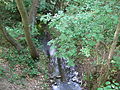
 Waldbach, shortly before the confluence with the Sauerbornsbach to the Schwalbach |
||
| Data | ||
| Water code | DE : 2489822 | |
| River system | Rhine | |
| Drain over | Schwalbach → Sulzbach → Nidda → Main → Rhine → North Sea | |
| source | in the Voraunus , south of Königstein - Mammolshain 50 ° 10 ′ 17 ″ N , 8 ° 28 ′ 53 ″ E |
|
| Source height | approx. 326 m above sea level NN | |
| confluence | in the city of Schwalbach with the Sauerbornsbach to the Schwalbach Coordinates: 50 ° 8 '52 " N , 8 ° 32' 11" E 50 ° 8 '52 " N , 8 ° 32' 11" E |
|
| Mouth height | approx. 132 m above sea level NN | |
| Height difference | approx. 194 m | |
| Bottom slope | approx. 38 ‰ | |
| length | 5.1 km | |
| Catchment area | 5.094 km² | |
| Discharge A Eo : 5.094 km² at the mouth |
MQ Mq |
38.3 l / s 7.5 l / (s km²) |
The Waldbach is the 5 km long right source brook of the Schwalbach in Hesse ( Germany ).
geography
course
The Waldbach rises in the Vordertaunus south of Königstein - Mammolshain . The source area extends in a forest area , which is located in a drinking water protection zone. The upper reaches of the Waldbach is also called Lotterbach. At first it flows south. To the right of him is the Ginzig state forest with its old chestnut trees . In its further course, the forest stream leaves the Hubertushöhe behind it on the left. From there the forest gives way to a meadow landscape. The forest stream now runs right through the fauna-flora-habitat meadows in the sweet green . In the protected area , spacious orchards , wet meadows and floodplains alternate. After leaving the protection zone, the stream flows around the Bad Soden- Neuenhain district in a slight curve from the east . At the steel well , the forest stream swings in a south-easterly direction. It crosses the boundary of Bad Soden and now flows along the western edge of the town of Schwalbach . After crossing under the S3 S-Bahn line , the stream reaches the core area of Schwalbach. It runs parallel to the Pfingstbrunnenstraße and then flows into the Schwalbach southwest of the main street .
Nidda river system
Localities
The villages on the Schwalbach include (viewed downstream):
|
Creature
The Waldbachtal is a varied biotope . In the northern forest areas there is an old tree population with numerous nesting and shelter options for birds and small mammals . The orchards, hedges and meadows to the south provide an ideal habitat for numerous birds, reptiles , amphibians and insects , including rare species such as the little owl and blue-black antblue .


Individual evidence
- ↑ a b Topographic Map 1: 25,000 and Google Earth
- ↑ Water map service of the Hessian Ministry for the Environment, Climate Protection, Agriculture and Consumer Protection ( information )
- ↑ Appendix to “The names of the waters of the Main-Taunus-Kreis”, Marieluise Petran-Belschner, Rad und Sparren, 1990 - issue 18
- ↑ Care concept of sweet chestnuts (sweet chestnut) in Königstein im Taunus ( page no longer available , search in web archives ) Info: The link was automatically marked as defective. Please check the link according to the instructions and then remove this notice. (PDF; 853 kB)
- ↑ Landscape plan UVF, December 2000 ( page no longer available , search in web archives ) Info: The link was automatically marked as defective. Please check the link according to the instructions and then remove this notice. (PDF; 2.8 MB)
Picture gallery

Waldbachquelle

Waldbach im Ginzig

Forest stream in the orchards near Neuenhain

edged forest stream
Waldbach just before Schwalbach


