
Urselbach
| Urselbach | ||
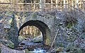
 The Urselbach in Heddernheim , near the confluence with the Nidda |
||
| Data | ||
| Water code | DE : 24894 | |
| location | Germany | |
| River system | Rhine | |
| Drain over | Nidda → Main → Rhine → North Sea | |
| source | in the Taunus on the White Wall near Oberursel 50 ° 13 ′ 36 ″ N , 8 ° 30 ′ 0 ″ E |
|
| Source height | approx. 470 m above sea level NHN | |
| muzzle | near Frankfurt-Heddernheim in the Nidda coordinates: 50 ° 9 '44 " N , 8 ° 39' 9" E 50 ° 9 '44 " N , 8 ° 39' 9" E |
|
| Mouth height | 102 m above sea level NHN | |
| Height difference | approx. 368 m | |
| Bottom slope | approx. 23 ‰ | |
| length | 16 km | |
| Catchment area | 33.32 km² | |
| Discharge A Eo : 33.32 km² at the mouth |
MNQ MQ Mq |
59 l / s 296 l / s 8.9 l / (s km²) |
| Left tributaries | see below | |
| Right tributaries | see below | |
The Urselbach , in the Hochtaunuskreis and in the area of the independent city of Frankfurt am Main in Hesse , is an approximately 16 km long, northern and orographically right tributary of the Nidda .
Surname
The part of the name Ursel comes from the earlier name Ursella for the old Oberursel, first mentioned in 791 in a deed of donation to the Lorsch Abbey .
Hans Krahe gives an interpretation of the name Ursel (bach) . He ultimately derives the documents 800 Ursalla, 821 Ursela 791 in uilla Ursella from the Illyrian . He analyzes the hydronym as old European with the suffix -elâ formed from Illyrian * urs-elâ to old Indian versati "it rains".
geography
course

The Urselbach rises in the Vordertaunus in the northwestern part of the Hohemark in the Oberursel district . Its source is about 6 km northwest of the Oberursel core town on the northern slope of the White Wall ( 634 m above sea level ) directly north of the Oberen Maßbornweg, which runs through the forest, at an altitude of about 470 m . On the opposite mountain slope to the north, the state road 3004 runs between Oberursel and the Sandplacken mountain pass ( 669 m ) .
In addition to the approximately 200 m long trickle that flows north from the source of the Urselbach, the upper reaches of the flowing water are fed by seven source or tributaries, all of which are significantly longer than the actual source trickle . They have the following names: Dreiborn, Hanswagnerborn, Buchborn, Hermannsborn, Kauteborn and Schellbach. The source zone of the seventh brook has no name. A little further down this brook is called Maßborn (Massborn) . The sources of these streams are usually layer springs . They are usually located on the border of the more permeable Hermes sandstone above dense colored slates or, if the fissure groundwater is flooded, a little higher. The main source of the Urselbach used to be the Buchborn, as can be seen from an old copper engraving from 1734 by P. Fehr. Today the springs are mostly used to obtain drinking water. The Schellbach used to be widely diverted to a mill ditch on the southern side of the Haidtränkbach (also called Haidttränkebach ). This means that its water also benefited the turbines of the earlier spinning mill.
Down the valley, the two main source brooks of roughly equal size, Maßborn and Buchborn, flow together a little below the actual source of the Urselbach at around 405 m above sea level and form what is also known as the Haidttränkebach, which initially travels eastwards. It lost its ecological value due to straightening measures during the expansion of Kanonenstrasse and especially in the 1960s. Some transverse dams tell of earlier construction work. Remnants of ecologically significant alder fragments with peat moss , capwort, loosestrife and swamp sedge are still present.
Near the former Heidetränke inn (also called Haidetränke ), which stands in the Bachtal on the lower south-western slope of the Goldgrube mountain ( 492 m ), the drinking water supply for the city of Oberursel is additionally secured by drilling wells. A level indicates when the stream has little water and the water supply has to be reduced. In the meantime, however, the stream is also losing water through deep-lying channels in the new development areas on the edge of its banks. In years with little rainfall, it can therefore fall dry in Oberursel . From the exit from the Vordertaunus, located below the inn, when passing both mountains, the stream, which mainly flows in a south-easterly direction, is only called Urselbach.
Shortly afterwards, the Urselbach changes from the forest to a meadow area. It crosses under the federal highway 455 and reaches the urban area of Oberursel. In Oberursel, the creek flows from its 6.8 km for 700 m in a southerly direction, and then runs south-east again. To the east of the Stierstadt district , it crosses the Weißkirchen district .
After crossing under the federal motorway 5 , the Urselbach reaches the area of the independent city of Frankfurt . It flows through the district of Niederursel , eventually in the district of Heddernheim to 120 m altitude in the north-east there about upcoming Main influx Nidda to lead .
Catchment area and tributaries
The catchment area of the Urselbach is 33.32 km². Its tributaries include (viewed downstream; also with kilometer information in the confluence column ):
| Surname | GKZ | location |
Stat. in km |
Length in km |
Mouth height in m above sea level NHN |
Mouth Coordinates |
|---|---|---|---|---|---|---|
| Maßborn | 24894-12 | Left | 15.8 | 2.7 | 450 | Oberursel ( ⊙ ) |
| Schellbach | 24894-16 | Left | 14.9 | 1.5 | 432 | Oberursel ( ⊙ ) |
| Stierstädter Bach | 24894-4 | right | 6.0 | 3.3 | 150 | Oberursel- Stierstadt ( ⊙ ) |
- ↑ Water code number , in Germany the official river code number with a separator inserted after the prefix for better readability, which stands for the Urselbach river , which is common to all .
Nidda river system
Localities
The villages on the Urselbach are (viewed downstream):
|
Data
The upper part of the Urselbach (the first 11 km to the river km 5) is of the type of a silicate low mountain range and the lower part (from river km 5) is a fine material rich carbonate low mountain range. The Urselbach has an average discharge of 295.8 l / s in its lower area.
Buildings
bridges
A large number of bridges lead over the Urselbach. These include (viewed downstream):
Above Oberursel, above the Urselbach, near the Kanonenstrasse to Schmitten, is the Kaiserin-Friedrich-Brücke , which is a listed building.
The largest bridge is the Urselbachtalbrücke on Federal Motorway 5 between Weißkirchen and Niederursel and opened on September 27, 1936 during the expansion of the Reichsautobahn. In World War II it was badly damaged. In 1953, half of the bridge was completed, on which traffic could barely run again. The two-lane bridge was rebuilt by April 1957 for a cost of 1.3 million marks. In 1972 the three-lane expansion of the bridge was completed. The cost of this construction measure amounted to 17 million marks and thus 4.5 million marks more than the original plan. In connection with the planned expansion to eight lanes, the residents' demand for a noise protection wall is part of the public discussion. The Mittelursel desert is located in the area of the south-south-western bridge abutment .
The classicist bridge over the stream in Spielgasse in Niederursel was replaced in 1984 by a new reinforced concrete structure. A listed bridge stone has been preserved, which is placed next to the bridge as a reminder.
Kaiserin Friedrich Bridge over the Urselbach above Oberursel

Urselbachtal bridge on the A5 between Weißkirchen and Niederursel

Bridge stone of the Urselbach Bridge on Spielgasse in Niederursel


Watermills
Up until the 19th century, the Urselbach carried enough water and, thanks to its gradient (around 250 meters difference in altitude over 15 kilometers of flow), provided enough energy to operate a large number of water mills along its course . Their waterwheels were driven either directly from the stream (with undershot wheels) or via trenches created for this purpose (with wheels above or backwards, via mill canals ). Seven of these mill ditches, the longest of them over three kilometers long, have been preserved to the present day. Along the Urselbach from Oberursel to the mouth near Heddernheim there are a total of 42 historical businesses that use hydropower ; of 20 of them, there are no more traces visible above ground due to demolition and recent overbuilding.
In Oberursel, the commercial operations made possible by the water mills, their products and the resulting tax revenue contributed significantly to the fact that the municipality was granted city rights in 1444. In the late 15th century, a total of 13 mills were counted in the urban area of Oberursel (including four fulling mills, three grinding mills and two each for oil, tinder and grinding mills); in the 19th century eight of them were still in use. The oldest working ditch in Oberursel that has been preserved is ascribed an age of 600 years.
In the area of today's Frankfurt district of Niederursel, which was a condominium of the Free Imperial City of Frankfurt and the County of Solms-Rödelheim until the 19th century , there were a total of ten watermills in 1885. Four fruit mills, a tobacco mill and a paper mill were located on Hessian territory, two fruit mills, a paint mill and an oil mill on Frankfurt territory. Of these ten mills, seven can be located:


- The crab mill was used as a grinding mill from the 17th century. In later years a bread factory was housed in the mill, which was closed in 1975. Today the buildings are used for apartments and commercial premises.
- The Hohe Mühle , like the paper mill mentioned below, was used to produce paper; it currently houses various small businesses and apartments.
- The former paper mill now houses apartments (baroque half-timbered building from 1695). The storage facility of the Untermühle am Urselbach has characteristic dormer windows for the drying floors under the roof. The storage building ("tobacco barn") is a listed building .
- The Schila or fulling mill, named after the miller Jakob Schila, was used for textile processing.
- The Obermühle - formerly Stalburg'sche Mühle after Claus Stalburg , Frankfurt councilor in the early 16th century - was the ban mill of Niederursel, probably on the site of the former castle. From 1720 to 1876 it was used as an oil mill, then as a grinding mill until 1952. The Niederurseler Reitclub is currently located in the buildings.
- The lower or cornet mill was built in 1695 by cornet ( ensign ) Heinrich Ludwig Heimburger, son of a Niederurseler mayor . It was popularly known as the tobacco mill because of the large drying barn with a mansard roof and dormers . It could have been used to dry paper flags. In 1699 Heimburger had a brewing kettle built in the mill with the consent of the House of Solms for brewing beer, which was destroyed a short time later on behalf of the City Council of Frankfurt. In 1702 Heimburger sold the mill to the county of Solms-Rödelheim and was employed there as an administrator. The baroque half-timbered house from around 1746 and the former mill building from the 17th century are listed buildings .
- The Christ or New Mill was used for metal processing.
A mill on the lower reaches of the Urselbach in today's Frankfurt-Heddernheim district, which has not survived and was demolished towards the end of the 19th century, achieved international renown thanks to an invention made there: In the sandel mill , first a grain mill and later a paper mill, the particularly opaque printing ink Frankfurter Schwarzer became which was widely used in the manufacture of art prints and banknotes. The street name An der Sandelmühle and the name of the Sandelmühle subway station , both located on the Urselbach in eastern Heddernheim, point to the history of the place up to the present day.
In the 2000s, the Mühlenwanderweg am Urselbach was set up along the course of the stream , with numerous information steles and an accompanying brochure published by the municipal authorities of Oberursel and Frankfurt as well as the Rhine-Main Regional Park, providing information about the former commercial use of the water.
literature
- Helmut Petran: Ursella II - mills, factories and people on the Urselbach . Waldemar Kramer Verlag, Frankfurt am Main 1980, ISBN 3-7829-0236-X
- Gudrun Koeniger, Jürgen Fischer: Mühlenwanderweg on Urselbach .
- Hartmut Fischer: Oberurseler brooks . Association for the Environment and Nature Conservation V., Oberursel / Steinbach local association, 2006
- Regional Park RheinMain Taunushang GmbH, City of Oberursel, City of Frankfurt am Main / Environment Agency (Ed.): The mill trail on the Urselbach from Oberursel (Taunus) to Frankfurt am Main. 1st edition, Frankfurt am Main 2010. Brochure, 28 pp. With extensive information on the history of the mills on the Urselbach and the ecology of the water
- City of Frankfurt am Main, Environment Agency (Ed.): City waters - discover rivers, streams, oxbow lakes . Frankfurt 2004. Therein: Chapter Urselbach, p. 75 ff.
Web links
- Description of the Urselbach in Frankfurt on Frankfurt.de
- Mill hiking trail in the town of Oberursel
- Retention cadastre river area Urselbach river area code number: 24894 (PDF; 391 kB)
- Fabriken und Mühlen am Urselbach, a fact book from the Industry and Crafts Working Group in the Association for History and Local History Oberursel eV, 2017 edition
Individual evidence
- ↑ a b c Map services of the Federal Agency for Nature Conservation ( information )
- ↑ a b c d e f Water map service of the Hessian Ministry for the Environment, Climate Protection, Agriculture and Consumer Protection ( information )
- ↑ a b Urselbach . Frankfurt.de
- ↑ Hans Krahe: Our oldest river names . Harrassowitz, Wiesbaden 1964, p. 56
- ↑ 182 Krahe gives this document as "791 Ursella"
- ↑ This receipt can be seen as an index card at Krahe in box four.
- ^ Geological map 1: 25000, sheet 5716, Oberreifenberg
- ↑ Fürl: The biology of the Haidtränktal landscape . In: Communications of the Association for History and Local History Oberursel , Issue 25, 1981
- ↑ T. Pottgiesser, M. Sommerhäuser: First revision of the profiles of the German river types. (PDF; 137 kB) Type 5: Coarse material rich, silicate low mountain streams. In: Umweltbundesamt.de. Federal Environment Agency , 2008, accessed on May 22, 2016 .
- ↑ Type 6: Carbonatic low mountain streams rich in fine material. (PDF; 177 kB) (No longer available online.) In: Umweltbundesamt.de. Federal Republic of Germany, formerly in the original ; accessed on May 18, 2016 . ( Page no longer available , search in web archives )
- ↑ Frankfurter Allgemeine Zeitung, July 7, 1956, p. 34 Completion of the Urselbach Bridge and Frankfurter Allgemeine Zeitung, January 7, 1956, p. 35 The Urselbach Bridge was not completed until 1957
- ↑ Frankfurter Allgemeine Zeitung, June 25, 1974, p. 27 Urselbach Bridge not threatened with collapse
- ↑ Frankfurter Allgemeine Zeitung, February 14, 2009, No. 38, p. 62, noise protection wall for Oberursel
- ↑ Heinz Schomann, Volker Rödel, Heike Kaiser: Monument topography city of Frankfurt am Main. Revised 2nd edition, limited special edition on the occasion of the 1200th anniversary of the city of Frankfurt am Main. Societäts-Verlag, Frankfurt am Main 1994, ISBN 3-7973-0576-1 , p. 674
- ↑ City of Frankfurt am Main / Environment Office (ed.): The Mühlenwanderweg am Urselbach . In it: Chapter mill and plant trenches (without pagination )
- ↑ City of Frankfurt am Main / Environment Office (ed.): The Mühlenwanderweg am Urselbach . In it: Chapter The mills on the Urselbach rattled ... (without pagination)
- ↑ City of Frankfurt am Main / Environment Office (ed.): The Mühlenwanderweg am Urselbach . In it: Chapter work trenches (without pagination)
- ↑ a b c d City of Frankfurt am Main / Environment Agency (ed.): The Mühlenwanderweg am Urselbach
- ↑ City of Frankfurt am Main / Environment Office (ed.): The Mühlenwanderweg am Urselbach . In it: Chapter The Lower Mill (without pagination)
- ↑ Manfred Gerner: Niederursel, Mittelursel: chronical records of a village, 1976, p. 116 ff.
- ↑ City of Frankfurt am Main / Environment Office (ed.): The Mühlenwanderweg am Urselbach . In it: Chapter sandel mill (without pagination)
- ^ City of Frankfurt am Main / Environment Agency (ed.): The Green Belt Leisure Card, 7th edition, 2011