Bizzenbach
| Bizzenbach | ||
| Data | ||
| Water code | DE : 24882 | |
| location |
Taunus
|
|
| River system | Rhine | |
| Drain over | Erlenbach → Nidda → Main → Rhine → North Sea | |
| source | northeast Vogelberg 50 ° 17 ′ 55 ″ N , 8 ° 38 ′ 11 ″ E |
|
| Source height | 390 m above sea level NHN | |
| muzzle | near Wehrheim in den Erlenbach Coordinates: 50 ° 17 '43 " N , 8 ° 34' 42" E 50 ° 17 '43 " N , 8 ° 34' 42" E |
|
| Mouth height | 105 m above sea level NHN | |
| Height difference | 285 m | |
| Bottom slope | about 71 ‰ | |
| length | about 4 km | |
| Catchment area | 9.5 km² (above the level ) | |
| Small towns | Wehrheim | |
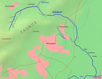
The Bizzenbach ( Pissebach ) is a low mountain range in the state of Hesse , Germany . It rises in the Taunus and flows into the Erlenbach .
geography
course
The Bizzenbach rises in the forest area of the Taunus, flows through the ammunition depot near Wehrheim and flows through the exclusively agricultural Bizzenbachtal in a westerly direction. He was originally the water supplier for the Ludwig-Bender-Bad (outdoor pool) of the municipality of Wehrheim . Today the stream runs right next to the swimming pool.
The Bizzenbach is almost completely straightened when it emerges from the forest. The country's statistics show it as 10% changed significantly, 77.5% as strongly changed and 12.5% as very strongly changed. From the entrance to Wehrheim, the stream mainly flows in a canalised bed of water.
Tributaries
- Langwiesengraben ( right ), 1.8 km, Wehrheim
Nidda river system
character
The Bizzenbach is a coarse material rich, silicate low mountain range. Its dominant fish region is the lower trout region .
In the summer the stream often falls dry. Responsible for this are water withdrawals through shallow wells (for agriculture and the swimming pool), the sealing in the area of the ammunition depot and agricultural drainage. The municipality of Wehrheim is planning to purchase a 10-meter shoreline on both sides of the stream (a total of 20 ha) for flood protection and renaturation measures and is carrying out a land consolidation procedure for this purpose.
Infrastructure
About one kilometer outside of Wehrheim is the Wehrheim outdoor pool in the Bizzenbachtal. In the neighborhood is the former Jewish cemetery of Wehrheim .
Bizzenbach desert
In the late Middle Ages, the town of Bizzenbach was located in the Bizzenbachtal (location: 50 ° 18 ′ 18.3 ″ N , 8 ° 35 ′ 54.1 ″ E ). It consisted of about 6 courtyards, which were subject to the monastery throne . The place Pissinbach is mentioned for the first time in 1310 in an interest list of the monastery. In its place, the remains of an oven and a brick well were found. The place was mentioned again on May 29, 1336. The last documentary mention was made in 1536. It is not known when exactly the place became deserted . In 1624 at the latest, however, the place went under. Theodor Geisel states that the place consisted of two parts, namely Ober- and Niederbizzenbach. (Location Ober-Bizzenbach: 50 ° 18 ′ 23.7 ″ N , 8 ° 36 ′ 48.2 ″ E ).
Individual evidence
- ↑ GESIS (Gewässerstrukturgurgüteinfosystem) ( Memento of the original dated August 6, 2007 in the Internet Archive ) Info: The archive link was automatically inserted and not yet checked. Please check the original and archive link according to the instructions and then remove this notice. of the MULV Hessen, the Bizzenbach can be found under the code number 24882, accessed: April 23, 2009
- ↑ Retention cadastre - Bizzenbach river area ( page no longer available , search in web archives ) Info: The link was automatically marked as defective. Please check the link according to the instructions and then remove this notice.
- ↑ Bund Osthessen zum Bizzenbach / Die Wasserpost No. 13: November 2003 ( Memento of the original from September 8, 2004 in the Internet Archive ) Info: The archive link was automatically inserted and not yet checked. Please check the original and archive link according to the instructions and then remove this notice.
- ↑ Usinger Anzeiger from April 20, 2009 ( page no longer available , search in web archives ) Info: The link was automatically marked as defective. Please check the link according to the instructions and then remove this notice.
- ↑ Johanna Kopp house: Wirena - Wehrheim. The Chronicle. J. Koppenhöfer, Wehrheim 2009, ISBN 978-3-00-028403-8 , p. 74.
- ↑ Jost Kloft: Territorialgeschichte des Kreis Usingen (= publications of the Hessian State Office for Historical Regional Studies. Vol. 32). Elwert, Marburg 1971, ISBN 3-7708-0421-X , p. 203.
- ↑ Heinrich Christ. Senckenberg (ed.): Selecta Ivris Et Historiarvm. Volume 1. Fleischer, Frankfurt am Main 1734, p. 204 .
- ↑ Theodor Geisel: The Usinger Basin and its peripheral areas. In: Yearbooks of the Nassau Association for Natural History. Vol. 84, 1937, ISSN 0368-1254 , pp. 81–197, here p. 131, (Cologne, University, dissertation, June 17, 1937; also as a special print: Ritter, Wiesbaden 1937).
- ↑ Bizzenbach (desert), Hochtaunuskreis. Historical local dictionary for Hessen. (As of July 23, 2012). In: Landesgeschichtliches Informationssystem Hessen (LAGIS).
- ↑ Ober-Bizzenbach (desert), Hochtaunuskreis. Historical local dictionary for Hessen. (As of November 4, 2010). In: Landesgeschichtliches Informationssystem Hessen (LAGIS).
Web links
- Hessian State Office for Environment and Geology , in the environmental atlas you can find information about the water quality
- List of species in the Bizzenbachtal
- Hessian State Office for Environment and Geology: retention cadastre, river area Bizzenbach - river area code number: 24882 (PDF; 10 kB) ( Notes )

