Laudenbach (Main, Laudenbach)
| Laudenbach | ||
|
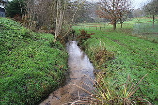
The Laudenbach in Laudenbach |
||
| Data | ||
| Water code | DE : 247352 | |
| location |
Odenwald
|
|
| River system | Rhine | |
| Drain over | Main → Rhine → North Sea | |
| origin | Confluence of Brunnthal and Ländlsgraben west of Laudenbach 49 ° 44 ′ 35 ″ N , 9 ° 9 ′ 4 ″ E |
|
| Source height | approx. 170 m above sea level NN at the confluence | |
| muzzle | in Laudenbach in the Main Coordinates: 49 ° 44 '44 " N , 9 ° 10' 43" E 49 ° 44 '44 " N , 9 ° 10' 43" E |
|
| Mouth height | 120.5 m above sea level NN | |
| Height difference | approx. 49.5 m | |
| Bottom slope | approx. 23 ‰ | |
| length | 2.2 km from the confluence 3.9 km with Brunnthal |
|
| Catchment area | approx. 9.5 km² | |
The Laudenbach is a left tributary of the Main near Laudenbach in the Miltenberg district in the Bavarian Odenwald . It arises from the confluence of the Brunnthal and Ländlsgraben west of Laudenbach.
Surname
The name Laudenbach consists of the Middle High German words lût and bach and means rushing, loud brook . The Laudenbach gave the place Laudenbach its name.
geography
Spring streams
Brunnthal
The 1.7 km long stream in the Brunnthal rises northwest of the hamlet of the same name belonging to Michelstadt . It runs in a south-easterly direction.
Ländlsgraben
The source of the Ländlsgraben, which is also around 1.7 km long, is located east of Bremhof . It flows to the northeast.
course
After the confluence of the source brooks, the Laudenbach runs eastwards to Laudenbach . At the beginning of the village, the Molkengraben runs to the right near the Fuchsmühle , and then the Schindgraben already in the local area . In the village, it is also reinforced by the overflow from the large Mühlbach spring drinking water source . It crosses under the federal highway 469 and flows into the Main .
See also
Web links
Individual evidence
- ↑ Hessenviewer (Geoportal Hessen) of the Hessian State Office for Soil Management and Geoinformation with property mapping ( information )
- ↑ a b c d BayernAtlas of the Bavarian State Government ( notes )
- ^ Wolf-Armin von Reitzenstein : Lexicon of Franconian place names. Origin and meaning . Upper Franconia, Middle Franconia, Lower Franconia. CH Beck, Munich 2009, ISBN 978-3-406-59131-0 , p. 128 ( limited preview in Google Book search).

