
Administrative community Kleinheubach
| coat of arms | Germany map | |
|---|---|---|
 Help on coat of arms |
Coordinates: 49 ° 43 ' N , 9 ° 13' E |
|
| Basic data | ||
| Existing period: | 1978– | |
| State : | Bavaria | |
| Administrative region : | Lower Franconia | |
| County : | Miltenberg | |
| Area : | 18.44 km 2 | |
| Residents: | 5932 (Dec. 31, 2019) | |
| Population density : | 322 inhabitants per km 2 | |
| License plate : | MIL, OBB | |
| Association key : | 09 6 76 5627 | |
| Association structure: | 3 municipalities | |
| Association administration address : |
Friedenstrasse 2 63924 Kleinheubach |
|
| Website : | ||
| Chairman : | Stefan Danninger | |
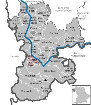
| Location of the Kleinheubach administrative community in the Miltenberg district | ||
  |
||

In the administrative community of Kleinheubach in the Lower Franconian district of Miltenberg , the following communities have come together to handle their administrative business:
- Kleinheubach , market , 3731 inhabitants, 9.5 km²
- Laudenbach , 1461 inhabitants, 4.94 km²
- Rüdenau , 740 inhabitants, 4.01 km²
The administrative association founded on January 1, 1976 is based in Kleinheubach.
Individual evidence
- ↑ "Data 2" sheet, Statistical Report A1200C 202041 Population of the municipalities, districts and administrative districts 1st quarter 2020 (population based on the 2011 census) ( help ).
Administrative communities in the Miltenberg district
Erftal |
Kleinheubach |
Kleinwallstadt |
Mönchberg |
Stadtprozelten
Former:
Amorbach |
Großwallstadt