
Administrative community Erftal
| coat of arms | Germany map | |
|---|---|---|
 Help on coat of arms |
Coordinates: 49 ° 43 ' N , 9 ° 16' E |
|
| Basic data | ||
| State : | Bavaria | |
| Administrative region : | Lower Franconia | |
| County : | Miltenberg | |
| Area : | 34.04 km 2 | |
| Residents: | 5705 (Dec. 31, 2019) | |
| Population density : | 168 inhabitants per km 2 | |
| License plate : | MIL, OBB | |
| Association key : | 09 6 76 5626 | |
| Association structure: | 2 municipalities | |
| Association administration address : |
Große Maingasse 1 63927 Bürgstadt |
|
| Website : | ||
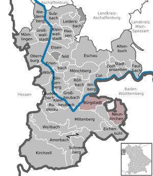
| Location of the Erftal administrative community in the Miltenberg district | ||
  |
||

In the administrative community of Erftal in the Lower Franconian district of Miltenberg , the following communities have come together to carry out their administrative business:
- Bürgstadt , market , 4242 inhabitants, 17.39 km²
- Neunkirchen , 1463 inhabitants, 16.65 km²
The administrative community is based in Bürgstadt.
The community of Eichenbühl, originally the third member, was dismissed from the administrative community on January 1, 1994.
Individual evidence
- ↑ "Data 2" sheet, Statistical Report A1200C 202041 Population of the municipalities, districts and administrative districts 1st quarter 2020 (population based on the 2011 census) ( help ).
- ^ Fourth law to change the structure of municipalities and administrative communities of November 9, 1993, GVBl p. 830
Administrative communities in the Miltenberg district
Erftal |
Kleinheubach |
Kleinwallstadt |
Mönchberg |
Stadtprozelten
Former:
Amorbach |
Großwallstadt