
Grubingen
Grubingen (later also: Grübingen) is a desert on the Main in what is now the Lower Franconian district of Miltenberg . The Church of St. Michaelis appears under this name in documents and files from the 14th century . Presumably that was settlement no later than the time of the Thirty Years' War about 1630 because of an early 17th century plague - epidemic abandoned. Only the existence of the Church of St. Michaelis (or St. Michael) is clearly documented under the name Grubingen. The use of the secular place name "Grubingen" exclusively for a church that was under the patronage of St. Michael is unlikely. In addition, a distinction was made in the field names between Grubinger property and that of the Church of St. Michaelis.
geography
Geographical location


Grubingen was part of the Upper Archbishopric of the Electorate of Mainz , whose administrative capital was Aschaffenburg.
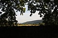
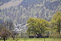
Today the area of the former settlement lies in the Bavarian part of the Spessart between Röllfeld and Großheubach , 8 km from today's district town Miltenberg , 28 km from Aschaffenburg , 65 km from Frankfurt am Main and 70 km from Würzburg on today's state road 2309 .
Today's churches
Today's communities are Laudenbach in the west , the Klingenberg district of Röllfeld in the north , where Grubingen is today, in the east Röllbach and Mönchberg and in the south Großheubach .
history

The ending "-ingen" of the name "Grubingen" indicates an Alemannic origin of the name. The names of the tub around the old cemetery make it likely that there was a courtroom there. The existence of a customs post is documented in a document from 1421.
Grubingen was first mentioned in a document at the beginning of the 14th century. Pope Clement V (1305-1314) awarded the parish church of St. Michaelis von Grubingen an indulgence . In 1368, Count Poppo IV von Wertheim (1260–1281) gave the pastor of Grubingen, who lived in Röllfeld , the Heuzehnten to Schmachtenberg and Röllfeld. In 1372, Konrad the Younger von Bickenbach donated his third at the church in Grubingen in the then diocese of Mainz to the Teutonic Order . In 1419 Count Johann von Wertheim exchanged his half at the village of Röllfeld and his part at the Kirchsatz zu Grubingen (the remaining two thirds) with the Teutonic Order for the Kirchsatz zu Kembach near Wertheim. From 1426 the right of patronage for Grubingen also lies with the Teutonic Order. Probably all pastors lived in the house of the Teutonic Order in Klingenberg from that year . This led to disputes between Klingenberg and Röllfeld in the 16th century. Among other things, the people of Klingenberg repeatedly made use of the Grubing church property. The steeple of the St. Pankratius Church in Klingenberg, which still exists today, was financed in 1617 with money from the assets of the parish in Grubingen. In 1623 the foundation stone was laid for a separate church in Röllfeld. In 1630, Archbishop Anselm Casimir's church property in Grubingen was distributed between the Klingenberg and Röllfeld branches. At the end of the 17th century, the number of church services in Grubingen had fallen sharply. The Schmachtenberg branch was looked after from Klingenberg until 1755. The branch in Laudenbach belonged to Röllfeld. In 1755 the church in Grubingen had become dilapidated and the archbishop's commissioner in Aschaffenburg was checking whether the church could be closed. However, numerous reports of miracles from Röllfeld were cited against it. The branch churches demanded a renovation of the Grubingen church. A part of the ceiling collapsed in the Grubingen church. In 1778 the archbishop commissioner in Aschaffenburg ordered the demolition of the Grubingen church and the erection of a crucifix with a memorial inscription . Pastor Johann Peter Stadtmüller from Mönchberg was authorized to do the demolition. The property was divided between the parish churches of Klingenberg and Röllfeld. The churchyard was closed and the maintenance of the cemetery wall was transferred to the two parishes. The material was sold. Among other things, the three bells were sold to the Church of St. John the Baptist in Mönchberg. In 1779 the cemetery was finally leveled under the direction of the pastors of Klingenberg and Röllfeld. In 1814 the area came to the Kingdom of Bavaria . In 1959, the east wall of the cemetery was moved to the west to make way for State Road 2309 . In 1979 the cemetery was restored.

Grubingen, interior view, view of the cross in the center

Grubingen, interior view
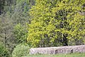
Grubingen, view of the state road 2309 to Großheubach
Grubingen, interior view, looking towards the entrance gate

Grubingen, interior view


St. Michaelis Church
The Romanesque church in Grubingen had four altars. At the cemetery there was a charnel house and the Holy Wendelin consecrated chapel .
Todays situation
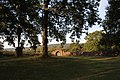
Grubingen, seen from the southeast, from the dirt road to the gravel pit
Grubingen, seen from the south-east, south-west corner, towards Laudenbach

Grubingen, seen from the southeast, in the foreground is State Road 2309
Grubingen, seen from the north


Today only the cemetery wall with the arched entrance portal can be seen from the outside . These remains of the entire church are about 1.5 km south of today's Klingenberg district of Röllfeld between the state road 2309 to Großheubach and the Main . In the middle of the former cemetery is the crucifix with the memorial plaque for the church, which the archbishopric of Mainz commissioned in Aschaffenburg in 1778.
literature
- Dieter Michael Feineis: Grubingen . In: Würzburger Diözesan Geschichtsblätter - special edition . 55th volume. Diocese of Würzburg, Würzburg 1993, p. 53–87 ( klingenberg-main.de [PDF; accessed on July 19, 2012]).
- Alexander Schöppner: Book of legends of the Bavarian country. From the mouths of the people, the chronicles and the poets . tape 2 . Contumax GmbH & Co. KG, 1852, p. 312 , 788 Grubingen ( bavarica.digitale-sammlungen.de ).
- Gudrun Berninger: GRUBINGEN . Ed .: Förderkreis Grubingen. Heinrich Bingemer Buchdruck, Obernburg + Klingenberg 1979 (documentation on the occasion of the restoration of the old cemetery 1976–1979).
See also
Web links
- Photos from nearby Grubingen - Alter Kirchhof
- Grubingen on Zeno.org
- The Schmachtenberger on the Totenweg to Grubingen
Individual evidence
- ↑ Dieter Michael Feineis: Grub Ingen. 1993.
- ^ Franz Schaub: Spessart walks. Süddeutscher Verlag, Munich 1982, ISBN 3-7991-6165-1 , p. 49.
- ^ A b Gudrun Berninger: Grubingen. 1979.
Coordinates: 49 ° 45 '2 " N , 9 ° 10' 48" E