
Hohberg
| coat of arms | Germany map | |
|---|---|---|

|
Coordinates: 48 ° 25 ' N , 7 ° 54' E |
|
| Basic data | ||
| State : | Baden-Württemberg | |
| Administrative region : | Freiburg | |
| County : | Ortenau district | |
| Height : | 179 m above sea level NHN | |
| Area : | 28.94 km 2 | |
| Residents: | 8073 (December 31, 2018) | |
| Population density : | 279 inhabitants per km 2 | |
| Postal code : | 77749 | |
| Area code : | 07808 | |
| License plate : | OG, BH , KEL, LR, WOL | |
| Community key : | 08 3 17 047 | |
| Community structure: | 3 districts | |
| Address of the municipal administration: |
Freiburger Strasse 32 77749 Hohberg |
|
| Website : | ||
| Mayor : | Klaus Jehle | |
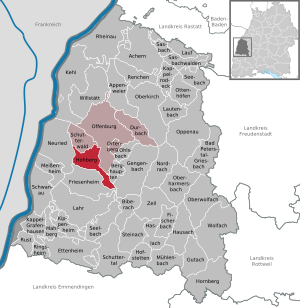
| Location of the community of Hohberg in the Ortenau district | ||
  |
||

Hohberg is a municipality in the Ortenaukreis in Baden-Württemberg .
geography
Geographical location
Hohberg is located on the western slope of the Black Forest on the edge of the Upper Rhine Plain, about 8 km from Offenburg .
Community structure
The following districts belong to the municipality of Hohberg (former municipalities with their districts):
- Diersburg with the teeth at the castle, castle moat, Molkensumpf and Ruhbühl and the courtyards Meierhof, Schucken- and Fegerhof
- Hofweier with the Marienhof farmstead and the Schwatterloch residential area
- Niederschopfheim with the Hexenmühle homestead (Deckersche Mühle)
Neighboring communities
The community borders in the north / northeast / east on the district town of Offenburg , Elgersweier district, Zunsweier district in the south on Oberschopfheim and Friesenheim and in the west on Höfen, Schutterwald and Ichenheim , Neuried .
history
Diersburg

The castle Diersburg was first mentioned as "stone Tiersperg" 1197 documentary. The village was first mentioned in 1257 as "Tiersperg" in a Strasbourg document. At that time it belonged to the dynasty of the Knights von Geroldseck . In 1279 the Knights von Schwarzenberg acquired the place and the castle. In the 14th century Diersburg went to the margraviate of Baden , so that it belongs to the older Baden possessions.
The lost moated castle Diersburg was first mentioned in 1393 and destroyed after 1488.
In 1455 Diersburg came with the "Stein zu Diersburg" to the noble Roeder family from Altortenau . Since then, this line has been called Roeder von Diersburg and still manages the Philippshof wine and forest estate in Diersburg today.
There is a "Goethe House" in Diersburg , although Goethe was never in Diersburg. Friederike Brion , Goethe's Sessenheim sweetheart, stayed with Pastor Marx's family for a few months. Marx was married to her sister Salome and looked after the Diersburg parish for a few years before he was transferred to Meißenheim .
Hofweier

Hofweier was mentioned as early as 1101 in a document from the Alpirsbach monastery . The place was subordinate to the Zähringers , who were also Counts of Ortenau. When these died out in 1218, Hofweier fell to the Knights of Geroldseck and in 1423 to the Hummel von Stauffenberg ( water castle Hofweier (Upper Castle), water castle Binzburg ). From 1530 the place was completely under the control of the knights of Bach , who were subordinate to the margraves of Baden .
Niederschopfheim

Of the three villages united today in the municipality of Hohberg, Niederschopfheim is the earliest mentioned - 777 as Scofhaim in the will of Fulrad , abbot of the Abbey of Saint-Denis . However, Scofhaim also meant today's Oberschopfheim ; Niderenschopfheim is only attested in 1289, when the two villages separated. The Widons had given Fulrad property in Scofhaim . In addition to Saint-Denis and Honau monastery, the Ettenheimmünster and Hohenburg monasteries had property in Niederschopfheim early on. In the 12th and 13th centuries the bishops of Strasbourg obtained local rule, which they gave to various families of knights as fiefs . From 1479 to 1538 it was the Knights of Bach. Georg von Bach († 1538), with whom the family died out and whose stone tomb by the hand of Christoph von Urach stands outside the Holy Cross Church in Offenburg , held Niederschopfheim during the Reformation with the Roman Catholic Confession. Other noble families followed, the same as in Hofweier; but these were landowners in Hofweier and Strasbourg fiefs in Niederschopfheim. The last were the Lords of Frankenstein .
see also Castle Niederschopfheim and St. Brigitta (Niederschopfheim) .
Hohberg community
The community of Hohberg was formed on January 1, 1973 as part of the community reform from the formerly independent communities Diersburg, Hofweier and Niederschopfheim. On May 3, 1972, the community of Hofweier was renamed Hohberg. The seat of the municipal administration is in Hofweier. The municipality is a unified municipality without a local constitution. The community name Hohberg was chosen after the name of a small elevation between the three districts. It is located roughly in the center of the community and can be seen from all three districts.
religion
The Reformation passed the districts of Hofweier and Niederschopfheim , so that they are still influenced by Roman Catholics . There is a Catholic parish each in Diersburg ( St. Karl Borromäus ), Hofweier and Niederschopfheim, with the three districts sharing a pastor. There is also a Protestant parish in Diersburg , which is responsible for Oberschopfheim and Zunsweier in addition to Hohberg .
Since 1738 there was a Jewish community and since 1773 there was a Jewish cemetery in what is now Diersburg. At the end of the 19th century it had 190 members. The synagogue was desecrated on November 9, 1938 and the community wiped out in October 1940 when the last Jewish citizens were deported.
politics
Municipal council
The municipal council election on May 26, 2019 brought the following result:
- Free voters: 44.2%, 10 seats (2014: 36.2%, 8 seats)
- CDU : 35.2%, 8 seats (2014: 38.2%, 8 seats)
- SPD : 20.6%, 4 seats (2014: 22.9%, 6 seats)
mayor
- 1973–1981 Michael Bayer
- 1981–1997 Hermann Löffler
- 1997 – today Klaus Jehle
coat of arms
Blazon : "In green, a golden, fallen triquetra ."
Declaration of the coat of arms: The motif comes from a capital of a column found in Niederschopfheim and at the same time symbolizes the three districts.
Partnerships
Hohberg maintains a city partnership with the following cities :
Culture and sights


Museums
The Hohberg local history museum is housed in a former cigar factory in Niederschopfheim. In Diersburg there is the Hohberger Bee Museum , which shows the history of beekeeping. With the history of viticulture and the Barons Roeder of Diersburg the concerned museum in the winery Roeder of Diersburg .
building
In Diersburg the ruins of Diersburg , a castle built in the 12th or 13th century, originally belonging to a sideline of the lords of Geroldseck (Tiersberger), have been preserved. Since the 14th century the castle has belonged to the Roeder von Diersburg family, who are still based in the village today.
Others
The cemetery of the former Jewish community still exists in Diersburg. In the village, a Hebrew inscription stone reminds of the former Jewish bath.
The remnants of a Roman road station can be found in the Niederschopfheim district (east of the A5 federal motorway).
The quarry pond, which is also located in the Niederschopfheim district, enjoys supraregional popularity. In the last measurement of the water quality in 2014 by official bodies of the European Union, the lake received the grade “excellent”.
Sports
Hohberg became known nationwide through the handball club TuS Hofweier , which belonged to the handball Bundesliga without interruption from 1974 to 1989 .
Economy and Infrastructure
traffic
Hohberg is connected to the national road network by the federal highway 3 ( Buxtehude - Weil am Rhein ).
The old station in Niederschopfheim has been closed.
education
In the district of Hofweier there is a community school , in the districts of Niederschopfheim and Diersburg there is a primary school each . All secondary schools are available in Lahr and Offenburg . For the youngest there are four Roman Catholic day-care centers and an ecumenical kindergarten that is supported by both denominations.
The Volkshochschule Offenburg has a branch in Hohberg.
Personalities
Sons and daughters of the church
- Eduard Riehm (1830–1888), Protestant theologian
- Isaak Blum (1833–1903), educator and scientist
- Hermann Ehrhardt (1881–1971), German naval officer and free corps leader
Web links
Individual evidence
- ↑ State Statistical Office Baden-Württemberg - Population by nationality and gender on December 31, 2018 (CSV file) ( help on this ).
- ^ The state of Baden-Württemberg. Official description by district and municipality. Volume VI: Freiburg region Kohlhammer, Stuttgart 1982, ISBN 3-17-007174-2 , pp. 394–397
- ↑ cm city media GmbH - www.cmcitymedia.de: Hohberg municipality | Home |. Retrieved February 21, 2017 .
- ↑ The history of Hofweier and his church has been researched in particular by the Offenburg high school teacher Otto Kähni (1900–1975), who had already written his dissertation on the subject of the “constitution and administration of the knightly village of Hofweier”. See Karlleopold Hitzfeld : Our chairman Professor Dr. Kähni 70 years. In: Die Ortenau 50, 1970, pp. 7-10 ( digitized version ).
- ^ Federal Statistical Office (ed.): Historical municipality directory for the Federal Republic of Germany. Name, border and key number changes in municipalities, counties and administrative districts from May 27, 1970 to December 31, 1982 . W. Kohlhammer, Stuttgart / Mainz 1983, ISBN 3-17-003263-1 , p. 500 .
- ↑ Facts from the Niederschopfheim Baggersee | Seen.de. Retrieved January 22, 2018 (German).

Achern | Appenweier | Bad Peterstal-Griesbach | Berghaupten | Biberach | Durbach | Ettenheim | Fischerbach | Friesenheim | Gengenbach | Gutach (Black Forest Railway) | Haslach im Kinzigtal | Hausach | Hofstetten | Hohberg | Hornberg | Kappel-Grafenhausen | Kappelrodeck | Throat | Kippenheim | Lahr / Black Forest | Run | Lautenbach | Mahlberg | Meißenheim | Mühlenbach | Neuried | Nordrach | Oberharmersbach | Oberkirch | Oberwolfach | Offenburg | Ohlsbach | Oppenau | Ortenberg | Ottenhöfen in the Black Forest | Renchen | Rheinau | Ringsheim | Rust | Sasbach | Sasbachwalden | Schuttertal | Schutterwald | Schwanau | Seebach | Seelbach | Steinach | Willstätt | Wolfach | Zell am Harmersbach
Rheinau (municipality-free area)