
Glaswaldsee
| Glaswaldsee | ||
|---|---|---|

|
||
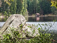
| The Glaswaldsee near Bad Rippoldsau-Schapbach | ||
| Geographical location | Baden-Württemberg | |
| Tributaries | Seebach | |
| Drain | Seebach | |
| Location close to the shore | Bad Rippoldsau-Schapbach | |
| Data | ||
| Coordinates | 48 ° 25 '33 " N , 8 ° 15' 43" E | |
|
||
| Altitude above sea level | 839 m above sea level NN | |
| surface | 2,969 5 ha | |
| length | 220 m | |
| width | 170 m | |
| scope | 650 m | |
| Maximum depth | 11 m | |
|
particularities |
||

The Glaswaldsee near Bad Rippoldsau-Schapbach in the Middle Black Forest is located in a cirque that is sunk into the steep eastern slope of the Lettstädter Höhe . It is part of the nature reserve established in 1960 under the same name .
The lake was carved out of the red sandstone by a glacier during the last ice ages . Steep banks line the lake, which is up to 11 meters deep and around 3 hectares in size. Its diameter varies between 170 and 220 meters. The Glaswaldsee is fed by underground water inflows; its above-ground catchment area, excluding an artificial by-line from the uppermost Seebach , only covers about 190 hectares.
In earlier centuries called Wilder See (like Wildsee am Ruhestein and Wildsee near Kaltenbronn), today's name goes back to the production of glass bottles in the neighboring towns. To this day, the water level of the Glaswaldsee has been raised by a sandstone wall, which in the past enabled the wood drift by means of surge and supported the rafting in the Wolf Valley .
The Glaswaldsee is one of the first lakes in the Black Forest to be trigonometrically measured and mapped. In 1655, Landgrave Friedrich Rudolf von Fürstenberg-Stühlingen commissioned the Basel pastor Jakob Mentzinger to draw up a map of his dominion in the Kinzig valley . Probably to illustrate his approach to land surveying, Mentzinger drew an enlarged view of the Glaswaldsee in the lower part of his map with the calculations he had made.

Glaswaldsee from the Lettstädter Höhe

Dam of the Glaswaldsee built in 1846
Glaswaldsee with a dam from the other bank

Water of the Glaswaldsee


See also
Web links
-
Geoportal Baden-Württemberg ( information ), especially with the partial maps / layers
- the State Institute for the Environment, Measurements and Nature Conservation Baden-Württemberg (LUBW)
- "LUBW-FG10": River 1: 10,000
- "LUBW-SG10": Standing water 1: 10,000
- "LUBW-GEZG": water catchment areas
- the State Institute for the Environment, Measurements and Nature Conservation Baden-Württemberg (LUBW)