Fleinheim
|
Fleinheim
municipality Nattheim
|
|
|---|---|
| Coordinates: 48 ° 42 ′ 29 ″ N , 10 ° 17 ′ 54 ″ E | |
| Height : | 542 m |
| Area : | 11.43 km² |
| Residents : | 442 (2019) |
| Population density : | 39 inhabitants / km² |
| Incorporation : | February 1, 1972 |
| Postal code : | 89564 |
| Area code : | 07327 |
|
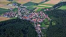
Fleinheim with the Zöschingen wind farm in the background
|
|
Fleinheim is a district of the municipality of Nattheim in the Heidenheim district ( Baden-Württemberg ).
geography
The place is five kilometers east of Nattheim not far from the border with Bavaria . The next larger town is Heidenheim an der Brenz, about eleven kilometers away . The Fleinheimer Bach , a tributary of the Egau , which rises to the west of the village , flows through it in the north.
history
Fleinheim was first mentioned in a document in 1277 . At that time it was owned by the Counts of Helfenstein . In 1504 the place came to the Duchy of Württemberg .
During the Thirty Years' War at the Battle of Nördlingen , Fleinheim was almost completely destroyed, only a few residents survived.
In the years from 1957 to 1960 the place got a sewer system and the streets were paved. On February 1, 1972, the previously independent municipality of Fleinheim was incorporated into the municipality of Nattheim.
Buildings
The Petruskirche in Fleinheim was built around 1350 and rebuilt in 1763 except for the tower.
traffic
The state road L 1181 connects Fleinheim with Nattheim and Dischingen . The A7 motorway runs six kilometers to the west . It can be reached via the junction Heidenheim (AS 116).
Web links
Individual evidence
- ↑ Nattheim community - data ( memento of the original from January 21, 2012 in the Internet Archive ) Info: The archive link was inserted automatically and has not yet been checked. Please check the original and archive link according to the instructions and then remove this notice.
- ↑ http://www.nordsuedien.de/fleinheim/geschichte1.html
- ^ Federal Statistical Office (ed.): Historical municipality directory for the Federal Republic of Germany. Name, border and key number changes in municipalities, counties and administrative districts from May 27, 1970 to December 31, 1982 . W. Kohlhammer, Stuttgart / Mainz 1983, ISBN 3-17-003263-1 , p. 449 .
- ↑ Archive link ( Memento of the original from October 11, 2014 in the Internet Archive ) Info: The archive link was inserted automatically and has not yet been checked. Please check the original and archive link according to the instructions and then remove this notice.


