
Niederstotzingen
| coat of arms | Germany map | |
|---|---|---|

|
Coordinates: 48 ° 32 ' N , 10 ° 14' E |
|
| Basic data | ||
| State : | Baden-Württemberg | |
| Administrative region : | Stuttgart | |
| County : | Heidenheim | |
| Height : | 473 m above sea level NHN | |
| Area : | 29.81 km 2 | |
| Residents: | 4693 (December 31, 2018) | |
| Population density : | 157 inhabitants per km 2 | |
| Postal code : | 89168 | |
| Primaries : | 07325, 07324 | |
| License plate : | HDH | |
| Community key : | 08 1 35 027 | |
| LOCODE : | DE NSG | |
City administration address : |
In the Städtle 26 89168 Niederstotzingen |
|
| Website : | ||
| Mayor : | Marcus Bremer | |
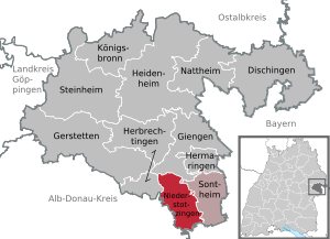
| Location of the city of Niederstotzingen in the Heidenheim district | ||
  |
||

Niederstotzingen is a small town in the Heidenheim district in Baden-Württemberg .
geography
Niederstotzingen is located on the south-eastern edge of the Swabian Alb between the Danube Valley and the Lone Valley , at 450 to 542 meters above sea level ; in the south lies the Swabian Donaumoos .
Neighboring communities
Niederstotzingen borders the city of Giengen an der Brenz in the north, Sontheim an der Brenz in the east, the Bavarian city of Günzburg in the south, Asselfingen in the Alb-Danube district and the city of Herbrechtingen in the west .
City structure
The city of Niederstotzingen consists of the districts ( residential districts within the meaning of the Baden-Württemberg municipal code) Niederstotzingen (residential district I), Oberstotzingen (residential district II), Stetten ob Lontal (residential district III), Lontal (residential district IV with the hamlet of Reuendorf). The districts are officially named by prefixing the city name and, separated by a hyphen, followed by the name of the districts. In the district of Stetten ob Lontal is the lost town of Kaltenburg.
Division of space

According to data from the State Statistical Office , as of 2014.
history
Until the 19th century
The district of Niederstotzingen has been settled since the Upper Palaeolithic , as finds from the nearby Vogelherd cave show.
The remains of a Viereckschanze come from Celtic times and the remains of a Villa Rustica between Niederstotzingen and Sontheim above the old Danube north road , which led from Urspring to Regensburg , from Roman times .
During construction work in the south of the city in 1962 was a small burial ground from the second half of the 7th century discovered on the 13 alemannische extremely valuable offerings were buried nobles with their animals and. It is considered the most important Alemannic grave in Germany. The men are high-ranking warriors and their entourage. The grave goods are of Franconian, Longobard and Byzantine origin, this indicates a "cultural openness" and proves that "members of the same family may have turned to different cultures". Genetic studies and those of the bones on regions of origin show that the high-ranking warriors come from different European regions and are apparently not related.
The name "Stotzingin" appeared for the first time in 1143; its meaning is uncertain. The lower aristocratic family Stotzingen named themselves after the place in the High Middle Ages , which still exists and resided in Niederstotzingen until around 1330. The rule then passed to the Lords of Riedheim . Emperor Karl IV. Allowed Wilhelm von Riedheim in 1366 to expand Niederstotzingen into a town and to fortify it. Emperor Sigismund confirmed the town charter in 1430, as did Emperor Matthias in 1617. The town kept town charter with a short interruption in the 19th century.
Around 1400 the lords of Leimberg acquired the rulership rights, of which they passed as inheritance to the knights of Westernach 50 years later . These exchanged Niederstotzingen in 1457 with the Lords of Stain for their rule Konzenberg . The Stain expanded the rule in the following centuries, acquired u. a. important privileges such as the exemption from foreign courts and purposefully led to the development of a free imperial knighthood.
During the Schmalkaldic War in 1546, the headquarters of Emperor Charles V was temporarily located in Niederstotzingen.
In 1550, the heirs of Bernhard vom Stain divided the rule into two parts: the "castle castle" (named after the older seat of local rule, the castle castle) and the "stone house" half, named after the stone house, a younger mansion. In 1565 Heinrich vom Stain, an important soldier, introduced the Reformation in his district , while his brother remained true to the old religion with the Steinhausian half. The subject was religiously divided for centuries; the Niederstotzinger church was used simultaneously until 1960 .
After the death of the childless Heinrich vom Stain in 1605, his part in Niederstotzingen fell to his cousin Leopold Karl, who was sitting on the neighboring Bächingen . In 1624 he divided his Niederstotzingen half among his sons again, so that three more closely or distantly related gentlemen ruled in Niederstotzingen. There was the Catholic Steinhausische, the Burgschlossische and the new Freihausische rule (named after another manor house in the city).
While the Steinhaus part was sold to the Kaisheim monastery in 1661 , the youngest part, the free house part, was reunited with the castle part in the hands of Karl Leopold von Stain, who had meanwhile risen to the rank of Count, after the childless last owner died in 1799. When he died in 1809 without any descendants, his nephew Joseph Alexander Graf von Maldeghem inherited the territories (in addition to Niederstotzingen also Riedhausen ) and his newly built castle. Niederstotzingen Castle is still in the hands of this family, who over the years expanded their possessions considerably by purchasing the neighboring Oberstotzingen and Stetten estates.
Larger fire disasters with up to 100 destroyed buildings have been handed down from the years 1579, 1622, 1725 and 1773.
After mediatization
From 1803 to 1806 the places in today's Niederstotzingen district fell to the Kingdom of Bavaria, which was established in 1806 . According to the border treaty between Bavaria and Württemberg , Niederstotzingen became part of the Kingdom of Württemberg and until 1819 belonged to the Oberamt Albeck, which was then incorporated into the Oberamt Ulm . In 1824 another major fire disaster occurred. In 1848 the lost town charter was restored by the Württemberg government. In 1875, when the Brenzbahn was built from Heidenheim, it was connected to the Württemberg railway network . In 1876 the section to Ulm was completed.
During the administrative reform of April 25, 1938 during the Nazi era in Württemberg , Niederstotzingen came to the Heidenheim district. After the Second World War, the city came under the American zone of occupation and thus belonged to the newly founded state of Württemberg-Baden , which was incorporated into the current state of Baden-Württemberg in 1952. A notable industrialization in Niederstotzingen only took place in the post-war period.
Religions
The majority of the community is Catholic (half of Niederstotzingen, Oberstotzingen, Stetten, Lontal). The Protestant congregation was founded in 1565. There is also a New Apostolic congregation.
Population development
The population figures according to the respective territorial status are estimates, census results (¹) or official updates from the State Statistical Office of Baden-Württemberg ( main residences only ).
|
|
Incorporations
March 1, 1972: Oberstotzingen, Stetten ob Lontal

Oberstotzingen

Stetten ob Lontal


politics

Municipal council
In Niederstotzingen, the municipal council is elected using the spurious selection process . The number of local councils can change due to overhang mandates . The municipal council in Niederstotzingen has 18 members after the last election (previously 19). The local elections on May 26, 2019 led to the following final result. The municipal council consists of the elected voluntary councilors and the mayor as chairman. The mayor is entitled to vote in the municipal council.
| Parties and constituencies |
% 2019 |
Seats 2019 |
% 2014 |
Seats 2014 |
||
| CDU | Christian Democratic Union of Germany voter bloc | 38.3 | 7th | 40.3 | 8th | |
| BWI | Citizens 'and voters' initiative | 36.5 | 7th | 34.4 | 6th | |
| SPD | Social Democratic Party of Germany | 25.2 | 4th | 25.2 | 5 | |
| total | 100 | 18th | 100 | 19th | ||
| voter turnout | 61.0% | 52.2% | ||||
mayor
In June 2016, Marcus Bremer was elected the new mayor with 72.2% of the vote. Before that, Gerhard Kieninger was mayor for 28 years.
coat of arms
The blazon of the coat of arms reads: "In green a silver drinking stump with silver fittings and a silver ring attached to the left."
Partnerships
Niederstotzingen has had partnerships with Stotzing in Burgenland in Austria since 1983 and with Bages near Perpignan in France since 1992.
Economy and Infrastructure
traffic
The city is connected to the supraregional road network via the Niederstotzingen driveway on federal motorway 7 ( Flensburg - Füssen ) seven kilometers away . State and district roads create the connection to the neighboring towns.
Niederstotzingen is located on the Brenzbahn ( Aalen - Heidenheim - Ulm ) and belongs to the Heidenheim tariff association. Two bus lines provide local public transport to neighboring communities and cities.
Established businesses
The garden tool manufacturer Gardena GmbH operates a metal processing plant in Niederstotzingen.
education
The city has a kindergarten in Niederstotzingen and one in Oberstotzingen. In Niederstotzingen there is a primary and secondary school with a Werkrealschule . The former elementary school in Oberstotzingen was rebuilt or rebuilt in 2008 as the Oberstotzingen “Villa Kaleidos” children's home. The children's home has been in operation since January 12, 2009. Realschule and grammar school are located in Langenau , Herbrechtingen and Giengen an der Brenz . Another secondary and secondary school is located in Sontheim an der Brenz .
Culture and sights
Buildings

- Niederstotzingen Castle, classicist building from 1780, built by Count von Stain on the site of the old castle ("Burgschloss") . Although the castle, which is owned by the Count's Maldeghem administration, was merged into an "indivisible and inalienable family property" - a Fideikommiss - in 1843 , it is now to be sold.
- Oberstotzingen Castle, built in the 16th century by the Bavarian noble family Jarsdorf from Jahrsdorf . In 1942 it served as a forced retirement home for Jewish seniors. Today castle hotel.
- Baroque church of St. Martin in Oberstotzingen, rebuilt in 1761 on the remains of a Roman wall.
- Andreas Church in Niederstotzingen
- Stetten ob Lontal Castle , built in 1583 by the von Riedheim family , redesigned in baroque style by Valerian Brenner in 1712 .
- Baroque pilgrimage church in Stetten, completed in 1733, with a copy of the Black Madonna of Einsiedeln .
- Kaltenburg Castle in the Lone Valley between the towns of Hürben and Burgberg . Extensive wall remains from the 12th century have been preserved.
Natural monuments

The Vogelherd Cave , discovered in 1931 in the Lonetal (5 km northwest of Niederstotzingen), where the famous Lonetalp horse was found , is known beyond the region due to the archaeological finds. 35,000 years ago it was a resting place and shelter for the Ice Age people.
Archaeopark
To the specific glacial discoveries and associated Vogelherd cave to bring better publicly validity was in Niederstotzingen-Stetten of 2013 Archeopark Vogelherdhöhle set up on the edge of Lonetales, an educational experience oriented prehistoric museum. In addition to a spacious outdoor area with action areas and access to the Vogelherd cave, the park includes a visitor and information center , in whose exhibition room two original Vogelherd figures are permanently presented. At the same time, the concept of the facility represents the Vogelherd cave in conjunction with the other archaeologically important Lone Valley caves .
The Archaeopark is part of the UNESCO project Caves of the oldest Ice Age art .
sport and freetime
In 1967 a small swimming pool was opened, which was closed in June 2011.
There are twelve sports clubs, 19 other clubs and seven other associations.
sons and daughters of the town
- Johann Christoph Friedrich Haug (1761–1829), professor at the Karlsschule in Stuttgart and court poet in Stuttgart
- Rudolf Friedrich Heinrich von Magenau (1767–1846), pastor and writer
- Jacob Friedrich von Magenau (1796–1857), Oberamtmann of Württemberg
- Johann Georg Mettenleiter (1812–1858), composer and church musician, born in Lontal
- Doris Koch (* 1960), visual artist and cultural scientist
- Andreas Merkle (* 1962), former professional footballer
Web links
- Website of the city of Niederstotzingen
- DNA of early medieval Alemanni warriors and their retinue deciphered September 5, 2018
Individual evidence
- ↑ State Statistical Office Baden-Württemberg - Population by nationality and gender on December 31, 2018 (CSV file) ( help on this ).
- ↑ Main statute of the city of Niederstotzingen from October 1, 2004
- ^ The state of Baden-Württemberg. Official description by district and municipality. Volume IV: Stuttgart district, Franconian and East Württemberg regional associations. Kohlhammer, Stuttgart 1980, ISBN 3-17-005708-1 . Pp. 625-629
- ↑ State Statistical Office, area since 1988 according to actual use for Niederstotzingen.
-
↑ Niall O'Sullivan et al .: Ancient genome-wide analyzes infer kinship structure in an Early Medieval Alemannic graveyard. In: Science Advances. Volume 4, No. 9, 2018, eaao1262, doi: 10.1126 / sciadv.aao1262
Nadja Podbregar: DNA gives insights into the Alemannic family. On: Wissenschaft.de from September 6, 2018. - ↑ DNA of early medieval Alemanni warriors and their retinue deciphered , press release from Eurac Research, September 5, 2018.
- ↑ Michael Price: 1400-year-old warrior burial ground reveals German fighters came from near and far , in: Science Sep. 5, 2018 ( website ) and research report by Niall O'Sullivan et al .: Ancient genome-wide analyzes infer kinship structure in an Early Medieval Alemannic graveyard. In: Science Advances. Volume 4, No. 9, 2018, eaao1262, doi: 10.1126 / sciadv.aao1262
- ^ Federal Statistical Office (ed.): Historical municipality directory for the Federal Republic of Germany. Name, border and key number changes in municipalities, counties and administrative districts from May 27, 1970 to December 31, 1982 . W. Kohlhammer, Stuttgart / Mainz 1983, ISBN 3-17-003263-1 , p. 450 .
- ↑ Ingrid Bauz, Sigrid Brüggemann, Roland Maier (eds.): The Secret State Police in Württemberg and Hohenzollern. Stuttgart 2013, ISBN 3-89657-138-9 , pp. 289ff.
- ↑ Südwest Presse from June 6, 2011 ( Memento from December 18, 2015 in the Internet Archive )
- ↑ Status: November 2007 Website of the city of Niederstotzingen ( page can no longer be accessed , search in web archives ) Info: The link was automatically marked as defective. Please check the link according to the instructions and then remove this notice.
