
Bolheim
|
Bolheim
City of Herbrechtingen
|
|
|---|---|
 |
|
| Height : | 484 (472-615) m |
| Area : | 22.4 km² |
| Residents : | 2983 (Dec. 31, 2019) [1] |
| Population density : | 133 inhabitants / km² |
| Incorporation : | March 1, 1972 |
| Postcodes : | 89542, 89522 |
| Area code : | 07324 |
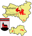
 The location of Bolheim and Anhausen in the urban area of Herbrechtingen.
|
|

Bolheim is a district of Herbrechtingen in the Heidenheim district in Baden-Württemberg . In the past, the spelling Bolheim / Württemberg was also used to avoid confusion with other localities. The place is in the natural areas Albuch-Härtsfeld and Lonetal -flächenalb . Until its incorporation, Bolheim was independent and had the municipality code number 137115.
geography
Bolheim is located in the district of Heidenheim , the Brenz flows through the town from north to south. On the eastern edge, the Brenzbahn passes the town, and federal highway 19 runs parallel to it .
Adjacent villages are (starting from the north clockwise) Mergelstetten , Herbrechtingen , Dettingen am Albuch , Heldenfingen , Küpfendorf .
The place has 2900 inhabitants (as of December 31, 2014), the municipal area is about 2230 ha, of which about 55% is forested. The place is on the edge of the largest contiguous forest area in all of Baden-Württemberg. The landscape is very diverse, ranging from a populated river landscape in the valley to extensive, almost unpopulated forest, arable and dry areas. The field names "-hau" and "Brand" indicate earlier clearings, which still exist in the center of the district today, those on the edge are now almost completely covered with forest. The Ugental is now a dry valley, thanks to the karst Swabian Alb. So far only one larger, at least 150 m long, cave is known - the Lindach cave.
Waters
Brenz
The Brenz flows through the Bolheim district over a length of 4 kilometers. In the northern part the Brenz is divided into two parts, the western arm is the driving water channel of the company Zoeppritz. Since floods could occur more often in the past, the Brenz was straightened in the 1970s, before the area was largely peppered with islands (hence the street name Wörthstraße). In the area between the Fischerviertel and the Wiedenwiesen, the Brenz was over 100 meters wide, but in places only a few centimeters deep and with a slower flow rate. The water management office (formerly mainly entrusted with straightening the rivers), which still operates its building yard in Bolheim, is now trying to restore parts of the original course of the river as far as possible, to restore the Brenz to its natural state, so to speak. Part of the water from the Brenz paves its way underground to the east, so a large part of the water bypasses the Brenzschleife through the Eselsburger valley .
Klosterbach, tributary of the Brenz
This small stream rises between a nursery in Bolheim and the pumping station of the state water supply. It is 1.5 kilometers long and has several small tributaries (not counting the length). The area in which it flows is called a reed and the stream is also called reed.
Wedel / Orstel, tributary of the Brenz
In the part of Bolheim to the east of the Brenz, a canal runs along its full length, which is intended to prevent the so-called frond from continuing to appear above ground. Today only the street names "Wedelstrasse" and "Grabenstrasse" and the Orstel dam indicate this event. The course of the river, also called Wedel, offers a comparable natural spectacle in the city of Heidenheim, both of which have their origins in the Karst of the Swabian Alb in the Ugental region between Bolheim and Heidenheim.
Other tributaries
have almost completely disappeared today. Along today's Bachstrasse, for example, there is only a small ditch, but there used to be a small lake at the confluence of the brook. Here, too, the brook, at the beginning of the 20th century, was still regularly carrying water, canalized and built over.
Settlements
District map: Bolheim, Anhausen

Area map of Bolheim
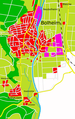
Road map of Bolheim

Bolheim and Anhausen in the Oberamt Heidenheim, territorial status 1813, with the earlier rule and office boundaries
legend
Markings Bolheim, Ugenhof and Anhausen in the Oberamt Heidenheim around 1860


- Bolheim (municipal area 1,800 ha)
- Anhausen (district area 435 ha) (3)
Anhausen Monastery: In the past also Brenzanhausen, a former Benedictine monastery in a solitary position in the valley . See main article Anhausen an der Brenz Abbey .
Anhausen settlement: The Mahlberg settlement northwest of the monastery was founded in 1953/60.
Riedmühle: The mill from around 1700, located near the former monastery on the Brenz, used to belong to the Anhausen monastery and had medieval predecessor buildings.
Wangenhof: In 1624 the court was already a state domain.
Buchhof: The courtyard was first mentioned in 1862 and was called Buch until 1965. Today the Buchhof can only be reached by the general public via an access road on the Buchhofsteige between the Reutenen and Mergelstetten.
Ugenhof: Was rebuilt in 1571. In the same place was previously Ugendorf, which came to Anhausen in 1291 and went down in the 14th century.
Neubolheim is a factory settlement founded in 1856, which at that time was almost a kilometer outside the closed town.
Former settlements
Burgstall Retzenberg: In the extensive forests west of Bolheim there are remains of a permanent house with late medieval settlement finds on a mountain spur.
Furtheim:
Settlement named after the lords of Fürheim in the entrance area of the Furtheim valley. The lost village secured the ford through the Brenz and was in turn secured by the nearby castle Hurwang (Furtheim). Since the crossing aid over the Brenz to reach the boner ore mines on the Retzenberg was of great importance, the place name could also have referred to "Furt". In the past, the castle and the abandoned village represented a unit, the castle is now in the Mergelstetten district, whereas the former settlement is in the Bolheim district.
history
In Roman times, Anhausen was part of the Gau "Alba" for Alb. Unfortunately, no district can be traced for Bolheim, as it was only mentioned later in a document, most likely it belonged to the same district as Anhausen or possibly Herbrechtingen - i.e. Raetia (Ries).
In 774 Bolheim was first mentioned in a copy of a deed of ownership of the Anhausen monastery , but documents only prove this from 1320 , the current name is derived from Bolem (hill) or Bol (swamp); both are likely, as the local conditions existed at the time of the naming, some parcels still have the names Brühl, Bühl, Breite and so on. Like the places in the immediate vicinity, the name Bolheim probably has its origin in the name of the location of the place. In the last few centuries the spellings Bollheim, Poll and Polheim were used, which are recorded on old maps of the Duchy of Swabia and Alemannia. The ending “-heim” is also very interesting - if you look at the five villages in the vicinity of the fort “Aquileja” in Heidenheim, a crossing point of the Roman roads. In the north lies Schnaitheim and in the south Bolheim, in the west Steinheim and Nattheim to the east.
The Ugenhof has its own delimitation because it was a small village in the past. As early as 1291 , the Anhausen monastery acquired goods in Ugendorf (also Uegendorf), which was the first time this was mentioned in writing. The place is said to have been deserted in the 14th century and as early as 1562 the Anhausen Monastery suggested repopulation in order to prevent the goods from being managed by the neighboring communities.
The church of Bolheim rises in the center of the village on the Lindenberg, a circulating hill of the early Brenz ; it does not have a church saint or is not known to this day. During restoration work it was found that today's church was built on the foundations of a much older one. The marshland disappeared at the latest when the Brenz was straightened out - nothing of it can be seen today.
In 1329 the Anhausen monastery appears to be wealthy in Altheim.
In 1406 the Anhausen monastery in Bolheim was struck.
In 1449 the war began against the Margrave Albrecht Achilles of Brandenburg-Ansbach, whose opponents were the Swabian and Franconian cities. In September of the same year the people of Ulm burned down the Anhausen monastery, among other places.
In 1492 there was already a village court (a magistrate is also mentioned): A Herrechtingen tenant farmer was denied his fief because he did not take enough care of it.
In 1529 the Retzenberg (formerly: Ratzenberg) was released for the mining of mineral resources by the patrician family Besserer from Ulm.
In 1550 the municipality of Bolheim sent a petition to the duke with the following points:
- Demand for a prohibition for the forest master to cut wood in the community forest at his own discretion
- No removal of the annual share of firewood from a controversial forest area between Bolheim and Anhausen Abbey
- It is forbidden for the Ulm forester to pick up wild fruit and acorns.
- Forester's ban on completely clearing part of the communal forest.
1646: On September 2nd, the Turenne army is approaching from Aalen. It is stored in the area of Mergelstetten and Bolheim.
In 1648 Anhausen and Bolheim finally became part of Württemberg because they belonged to the Heidenheim rulership.
In 1802, Anhausen and Bolheim were incorporated into the newly founded Oberamt Giengen.
In 1808 the Oberamt Giengen was dissolved again, Anhausen and Bolheim went back to the Oberamt Heidenheim.
According to the royal manifesto of Frederick I of Württemberg regarding the division of the country in 1810, Bolheim and Anhausen were official places.
In 1830 the boundary of Anhausen was still clearly within the present-day settlement area of Bolheim. The local border ran behind the town hall.
1838 Allocation of the former Anhausen monastery with Riedmühle, Ugenhof and Wangenhof to the municipality of Bolheim.
1896: Plans to connect the Amstetten – Gerstetten local railway to the Brenz Railway around 1913. These were finally rejected in 1921 by the Reich Ministry of Transport. The route was supposed to pass Heldenfingen in the north and be connected in an arch through a train station in the southeast of the village. In the further course of the route, the route would have run parallel to today's country road, with another train station to be built in the north of Heuchlingen. Dettingen would be bypassed in an arch and a train station would be added to the southeast. The route to Bolheim should run past the Lochhäule over the Kiessental. Another train station should have been built in the north of the Anhausen monastery and ultimately the line at Herbrechtingen station should have flowed into the Brenzbahn. In a further variant, it was planned that the route via Albstraße would touch the south of Bolheim and be connected to Herbrechtingen with a train station near the Bolheim town hall. In both cases the Brenz should have been crossed by a bridge structure.
1906–1945: III S was the license plate number for the municipalities of the Heidenheim Oberamt in the Jagstkreis, to which Bolheim was one. After the Second World War, license plates were issued in the state of Württemberg-Baden as follows: 1948–1956 AW (American Württemberg-Baden ), 1950–1956 W and WB (both Württemberg-Baden), since July 1, 1956 the one that is still in force today License plate HDH for the district of Heidenheim . On August 28, 1953, the section between Mergelstetten and Herbrechtingen of the B19 federal road, which was largely in the Bolheim district, was put into operation as the first prestressed concrete road on the European continent and test section. Shortly after the opening, the first accident victim was to be complained about.
1950–1958 the residential area Mittling was built northwest of the town center.
1965–1972 in the west the Buchfeldle, in which the later secondary school was built.
As a result of industrialization, Bolheim no longer developed from the core town, but from the Zoeppritz plant north of the town center on an artificial island. The company premises and later also the settlement near the company premises was called Neubolheim. In the course of the 20th century, the previously structurally separate Neubolheim grew together with Bolheim to the south.
The Catholic parish church of St. Martin has existed since 1963, the parish has existed since 1970.
Bolheim was until 1972 an independent market town and was on March 1 with its neighborhood Anhausen to Herbrechtingen incorporated.
Before the incorporation, Bolheim was the largest municipality in the Heidenheim district with around 2896 inhabitants at that time, and was incorporated into another in the course of the last municipal reform. The still independent communities Hermaringen , Dischingen , Nattheim , Niederstotzingen (city) were significantly smaller and Sontheim an der Brenz with about 2964 inhabitants was only slightly larger.
In 1973 the gap in the north between Bolheim and Neubolheim, called "Hinter den Bühlen", was closed.
Up until the 1970s there was a forest office in both Bolheim and Anhausen.
The residential areas Wiedenwiesen (late 80s) and, after a longer period of rest, Obere Wiesen (in the second decade after the turn of the millennium) were created later, both of which are mostly noticeable due to their narrow construction.
At the turn of the millennium, solar power was used in particular for energy generation. On the roof of the former company Zoeppritz, solar collectors are installed on an area of 1.6 hectares. The water extraction of the previous pumping station is also to be further exhausted by a new building.
The former Bolheim municipal coat of arms
On March 9, 1953, the coat of arms was awarded by the provisional government: Under a red shield head, inside a double row of black and silver (white) cut bar, in silver on a black mountain a red, black-covered church with silver windows and doors. The black and silver pinned bar is taken from the coat of arms of the Anhausen monastery, the church goes back to the coat of arms of the monastery office of Anhausen.
population
| year | Bolheim | Anhausen | total |
|---|---|---|---|
| 1632 | 865 | 86 | 951 |
| 1634 | 92 | - | - |
| 1650 | - | 64 | - |
| 1834 | - | - | 900 |
| 1844 | 948 | 84 | 1032 |
| 1852 | - | - | 1052 |
| 1858 | - | - | 1110 |
| 1871 | - | - | 1238 |
| 1880 | - | - | 1190 |
| 1890 | - | - | 1163 |
| 1900 | - | - | 1120 |
| 1910 | - | - | 1214 |
| 1925 | - | - | 1354 |
| 1929 | - | - | 1448 |
| 1933 | - | - | 1448 |
| 1939 | - | - | 1519 |
| 1950 | - | - | 2252 |
| 1956 | - | - | 2607 |
| 1961 | - | - | 2898 |
| 1970 | - | - | 3094 |
| 1972, March 1st | 2700 | 360 | 3060 |
| 1999 | - | - | 3183 |
| 2004 | - | - | 3180 |
| 2005 | - | - | 3210 |
| 2006, Dec. 31 | 2912 | 240 | 3152 |
| 2007, Dec. 31 | 2916 | 241 | 3157 |
| 2009, December 31 | 2883 | 230 | 3113 |
| 2010, December 31 | 2907 | 244 | 3151 |
| 2011, December 31 | 2905 | 247 | 3152 |
| 2012, December 31 | 2888 | 252 | 3140 |
| 2013, December 31 | 2934 | 240 | 3174 |
| 2014, December 31 | 2900 | 229 | 3129 |
| 2016, December 31 | 3006 | 239 | 3245 |
| 2017, December 31 | 2992 | 239 | 3231 |
| 2018, December 31 | 3000 | 244 | 3244 |
| 2019, December 31 | 2983 | 251 | 3234 |
statistics
- approx. 134 inhabitants per square kilometer
- Proportion of foreigners 5.2%
Say
Seven Swabians
In Bolheim, part of the landscape protection area there is officially called the rabbit hole after an incident by the Seven Swabians . Formerly seven trees (after storm damage in 2017 only six) growing in a row in an otherwise woodless place are still today a reminder of the alleged encounter between the Swabians and the hare there.
Treasure of Furtheim Castle
It is said to this day that a treasure with a golden crown is buried on the Furtheim castle ruins (also known as the Hurwang ruins). Many a treasure hunter had already dug for the treasure at night. But no one has ever found him. Nevertheless, many people believe in the legend of the buried treasure.
Sights and culture
Attractions
- Furtheim castle ruins
- Retzenberg Castle Stables
- Anhausen Monastery
- Lindenberg School
- Riedmühle
- Hasenloch landscape protection area in the west with extensive forests
- Eselsburger Tal nature reserve south of Anhausen Monastery
- Lindach cave (natural monument)
- The Urweltpfad Bolheim , whose start and finish point is at the hiking car park at Brunnenhau, is an 8-kilometer circular path, partially paved and leads through the Ugental, the Klifflinie, the Wangenhof, the Tiefer Weg nature reserve and the quarry. The path is part of the European Geopark Swabian Alb.
- The Evangelical Parish Church is located at the highest point in the center of the village and was essentially medieval, expanded and rebuilt in the 17th and 18th centuries. It was not until the end of the 20th century, during restoration work in the church and work on the foundation, that indications were found that a church had already stood in the same place. From this it can be concluded that the town was founded long before Bolheim was first mentioned in a document.
Events
- An international horse show takes place regularly in Bolheim.
- Bolamer Dorffeschd (Bolheim Village Festival), annually at the end of July (formerly: Gassenfest, Swabian: Gassafeschd)
- Children's festival, annually with a pageant from the valley, through the town center up the Lindachsteige to the fairground
- Florianshock of the Bolheim fire department
- Installation of the maypole by the Bolheim fire department
Sport and play
The sports club Bolheim 1900 e. V. today has around 1100 members and was formed in 1971 from RSV and TV Bolheim.
Facilities (summer):
- Kneipp facility at the Riedmühle
- Cliff hut between Ugenhof and Wangenhof
Facilities (winter):
- Trails
- Ski slope with a temporary lift
Economy and Infrastructure
Facilities
- Waterworks: Together with the plants in Bad Überkingen, Eybach and Lonsee, the waterworks in Bolheim supplies 46,000 inhabitants on the Eastern Alb (in the districts of Alb-Danube, Heidenheim and Göppingen) with fresh water. The respective output amounts to 1,000,000 m³ per year, except in Lonsee, there it is only about 300,000 m³ per year. The delivery rate is to be increased at the Bolheim plant in the following years. Studies have shown that the maximum expansion stage for production in Bolheim and in the Eselsburger Tal is around 5 million cubic meters per year. The supply area extends from Bad Überkingen to Bolheim and from Böhmenkirch to Lonsee.
- The water management office in Bolheim is responsible for the Württemberg part of the Brenz
- Buchfeld School: Elementary and special school
traffic
- Alb Railway: There was a plan according to which a railway line was to be built between Gerstetten and Bolheim to connect the Brenz Railway with the Amstetten – Gerstetten local railway . A faster connection to Stuttgart would have been possible.
- Shipping canal: The shipping canal between Neckar and Danube would have run alongside the B 19 and would have passed Bolheim on the eastern edge of the town. Before the opening of the new B 19 route , there was still a gap between the Hohe Wart and the center of Herbrechtingen. It would have been necessary to use several boat lifts to bridge the height difference. However, the Main-Danube Canal was awarded the contract .
rails
Streets
In the Mittling and Hinter den Bühlen areas , the streets were named after trees and bushes. In the so-called fishing district, the streets, as the name suggests, are named after fish species. The Öschwengle was given bird names. In the Buchfeldle and in the old town center , the local conditions and the neighboring towns were used for the street names. Field names were assigned to the new building area in the Wiedenwiesen , and famous Bolheim personalities were honored in the new building area south of Neubolheim . In the Fischerbreite industrial park , only professions were used as namesake.
Federal roads : B 19 : often incorrectly marked as Heidenheimer Straße in local maps, this name is not possible because it is already assigned to the same district. The section is officially called Bolheim-Ost.
State roads:
- L 1164: Heidenheimer Straße, Albstraße (4)
- L 1082: Zoeppritzstrasse, Herbrechtinger Strasse
former district roads:
- K 3018: Riedstrasse
- Herbrechtinger Strasse
Historical changes in street names
| Old street name | New street name | annotation |
|---|---|---|
| Meadow road | In the Stegwiesen | After incorporation: Because of double naming in the city area |
| Badgasse | Water alley | |
| Main road | Herbrechtinger Strasse | Hauptstrasse and Herbrechtinger Strasse were merged |
| Brenzstrasse | Embankment | After incorporation: Because of double naming in the city area |
| Schulstrasse | Lindenbergplatz | |
| Brunnengasse | Short street | The confluence of Kurz Strasse and Uferstrasse became private property |
| Finkenweg | Milan Street | |
| Anhauser Strasse | Albstraße | |
| Steinstrasse | was a way between Bergstrasse and Bühlstrasse | |
| Conifer path | middle part of Gartenstrasse |
Persons connected with Bolheim
- Georg Schwarz, (born December 20, 1862 in Bolheim, † August 5, 1929 in Heilbronn), car designer
- Karl Götz (born March 11, 1903 in Neubolheim, † February 9, 1989 in Stuttgart), author, teacher, SS-Sturmbannführer
- Albrecht Unsöld (born April 20, 1905 in Bolheim, † September 23, 1995 in Kiel), astrophysicist
- Heinz Zeller (born August 31, 1925 in Bolheim, † June 24, 1992 in Heidenheim an der Brenz), writer, dialect poet
Web links
Individual evidence
- ^ Federal Statistical Office (ed.): Historical municipality directory for the Federal Republic of Germany. Name, border and key number changes in municipalities, counties and administrative districts from May 27, 1970 to December 31, 1982 . W. Kohlhammer, Stuttgart / Mainz 1983, ISBN 3-17-003263-1 , p. 449 .
- ^ From: Description of the Oberamt Heidenheim ; Issue 1844, page 143
- ↑ Urweltpfad Bolheim ( page no longer available , search in web archives ) Info: The link was automatically marked as defective. Please check the link according to the instructions and then remove this notice. (PDF; 1.5 MB), City of Herbrechtingen, accessed May 14, 2011
- ↑ Regional plan , see map section
Remarks
- ↑ The description of the Upper Office Heidenheim breaks down this number into 1020 Protestant and 12 Catholic residents.