Lüttingen
|
Lüttingen
City of Xanten
|
|
|---|---|
| Coordinates: 51 ° 40 ′ 22 " N , 6 ° 27 ′ 35" E | |
| Height : | 19 m |
| Residents : | 2100 (Dec. 31, 2000) |
| Postal code : | 46509 |
| Area code : | 02801 |
|
Location of Lüttingen in Xanten
|
|
Lüttingen is a district of Xanten and forms the city district of Lüttingen with the surrounding area .
geography
Lüttingen is located in the Lower Rhine plain west of Wesel at the Rhine kilometer 827. Lüttingen is bounded by the Rhine in the north, the town of Beek in the east, the town of Xanten in the south and the Xanten South Sea, part of the Xanten leisure center , in the west .
history


The founding of Lüttingen goes back to a gift from Archbishop Brun of Cologne in 965 . He bequeathed a court called "Lidron" to the Benedictine Abbey of St. Pantaleon in Cologne . The place name Lüttingen was later derived from this name. The monks settled the area and built a church under the patronage of St. Pantaleon . In addition to agriculture , fishing has been the livelihood of the Lüttingse Prekke for centuries , as the residents are also called in dialect . The first documentary mention of Lüttingen comes from the year 1236 .
St. Pantaleon Church
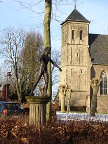
The current Lüttingen church, the tower of which was destroyed in the Second World War and then rebuilt - but with a shortened spire - was built around 1473 , but the choir building is older and was built on the foundations of the previous buildings.
Modern times
In 1965 the millennium of the fishing village Lüttingen was celebrated. In 1999 the “Fischerhütte vom Pärdendyck” on the “Xantener Südsee” near the village was reconstructed by the local community and citizens' association. It had stood on the banks of the Rhine centuries earlier and is today supposed to be a reminder of the origins of the village in Lüttingen.
In 2000 the population of Lüttingen was just under 2,100. However, the urban development of the city of Xanten is planning to designate the areas around the village as a building area and thus continue to enlarge Lüttingen.
This also included keeping the Lüttingen school location attractive for young families and further developing it in keeping with the times. The Hagelkreuzschule was expanded by two trains in two construction phases in 1994/1995 and 1999/2000. Within the last 15 years, a small village school has now become a modern house of learning with around 300 children in 12 classes and 21 employees for teaching, supervision and administration.
politics
coat of arms
The Lüttingen coat of arms shows a leaping salmon , which refers to the former fishing industry in Lüttingen. The green background indicates agriculture as the main line of business. The colors red and golden yellow of the fish indicate that it belongs to the former Duchy of Cleves .
Attractions
- Cast of the so-called Lüttinger Knaben , a Roman bronze sculpture, in Berlin today
- the church of St. Pantaleon
- Lüttingen has a stake in the Xanten Leisure Center , FZX for short, a local recreation center and is to have a sports and leisure port on the Xanten South Sea in the near future .


