Achdorf (Blumberg)
|
Achdorf
Community Blumberg
|
||
|---|---|---|
| Coordinates: 47 ° 50 ′ 14 " N , 8 ° 30 ′ 4" E | ||
| Incorporation : | April 1, 1972 | |
| Postal code : | 78176 | |
| Area code : | 07702 | |
|
Location of Achdorf in Baden-Württemberg |
||
|
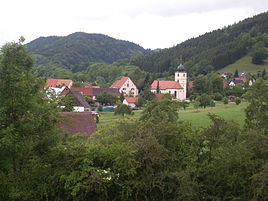
View of Achdorf (2012)
|
||
Achdorf is a district of the city of Blumberg in the eastern Wutach Valley in the Black Forest-Baar district in Baden-Württemberg .
history
The first mention of the place Achdorf goes back to the year 775. The names of the other places that still exist today go back to the years 802 (Aselfingen), 10th century (Eschach and Opferdingen) and approx. 1300 (Überachen). A coin of Magnentius was found in Achdorf . In 1397 Achdorf came to Berthold Keller von Stühlingen, church lord in Achdorf, together with roofs from the nobles von Blumberg. 1404 from this to Heinrich Irmensee von Schaffhausen . 1409 from his last descendants to Hans Cron, citizen of Schaffhausen, who sold it to the St. Blasien monastery in the same year . In 1803 Achdorf came to the Grand Priory of the Order of Malta . In 1805 in the Peace of Pressburg , Achdorf came to the Kingdom of Württemberg and in 1806 to the Grand Duchy of Baden .
On April 1, 1972, Achdorf was incorporated into the city of Blumberg.
Modern times
Until the municipal reform in 1972, the towns of Aselfingen and Überachen in the Wutachtal and the towns of Eschach and Opferdingen in the Krottenbachtal, the so-called Obertal, belonged to the former main town of Achdorf . In the former area, the desert areas of Helzenhofen and Katzaunstaige were located south of Achdorf, Weschbach and Mühlefingen west of Aselfingen, Bachreuthof and Dampfhausen north of Aselfingen in the Aubach Valley, Zimmer and Keglingen in the triangle of Opferdingen, Eschach and Riedböhrigen in the forest. The deserted villages are still partially Gewannamen .
geology
The Wutach has dug itself deep into the sedimentary rocks of the Jura . Around Achdorf there are some outcrops of the Lias . On the steep slope of Eichbergs among others are pyritized ammonites of Doggerformation found.
Infrastructure and economy
The community is dominated by agriculture; a few farms are run as their main occupation. In addition, tourism has long been an important source of income.
traffic
Streets
The K 5742 cuts through the municipality from north to south. It connects the villages of Achdorf, Eschach and Opferdingen with the neighboring villages of Fützen in the south and Hausen vor Wald , northeast of Opferdingen. The Achdorf-Fützen road section is also a listed building and is often referred to by the locals as a corrugated iron path , not only because of the interesting route . It leads over slope formations of the Keuper which together with source horizons leads to this wave formation . The district roads 5747 and 5743 are the roads from Achdorf to Blumberg or in the direction of Wutachmühle to the district boundary, the K5744 connects sacrifices with Riedböhringen. There are also several municipal roads that connect the Achdorf Valley with the towns of Lausheim , Blumegg and Ewattingen in the Waldshut district.
train
The Wutach Valley Railway , inaugurated in 1890, was to be connected to the Neustadt in the Black Forest-Bonndorf railway line in the Black Forest via a switch at Lausheim station through the Wutachfluchten and the upper Wutach Valley . Due to the wars in the first half of the 20th century and the advent of the automobile, the plans were finally discarded. The Neustadt - Bonndorf railway line has been completely dismantled.
Personalities
In the municipality of Achdorf, the famous poet Josef Viktor von Scheffel (1826–1886) occasionally made a guest appearance in the Linde zu Achdorf , which is now called Scheffellinde .
politics
There is a mayor in Achdorf .
coat of arms
The coat of arms is split, it shows the golden stag of the monastery St. Blasien and a green tree as a reference to the bushel- linden .
literature
- Freiburg administrative district (Ed.): The state of Baden-Württemberg. Official description by district and municipality. Volume VI, Kohlhammer, Stuttgart 1982, ISBN 3-17-007174-2 .
- Kurt FJ Sauer, Martin Schnetter (Ed.): Die Wutach. Natural history monograph of a river landscape . (= The nature and landscape protection areas of Baden-Württemberg . Volume 6). On behalf of the Baden State Association for Nature Conservation . 1971. (1988, ISBN 3-88251-135-4 )
Individual evidence
- ↑ St. Gallen Document Book, Volume 1, p. 71.
- ↑ StiASG , Urk. I 119. Online at e-chartae , accessed on June 12, 2020.
- ^ Federal Statistical Office (ed.): Historical municipality directory for the Federal Republic of Germany. Name, border and key number changes in municipalities, counties and administrative districts from May 27, 1970 to December 31, 1982 . W. Kohlhammer, Stuttgart / Mainz 1983, ISBN 3-17-003263-1 , p. 495 .


