
Wutach
| Wutach | ||
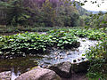
 The Wutach near Tiengen between the Steina and Schlucht estuaries |
||
| Data | ||
| Water code | DE : 2198, CH : 674 | |
| location |
|
|
| River system | Rhine | |
| Drain over | Rhine → North Sea | |
| source | in the Black Forest at Seebuck as Seebach 47 ° 52 ′ 14 ″ N , 8 ° 0 ′ 58 ″ E |
|
| Source height | 1440 m above sea level NHN | |
| muzzle | in the Rhine near Waldshut-Tiengen Coordinates: 47 ° 36 ′ 51 ″ N , 8 ° 14 ′ 59 ″ E 47 ° 36 ′ 51 ″ N , 8 ° 14 ′ 59 ″ E |
|
| Mouth height | 315 m above sea level NHN | |
| Height difference | 1125 m | |
| Bottom slope | 12 ‰ | |
| length | 91 km | |
| Catchment area | 1,139.6 km² | |
| Discharge at the Oberlauchringen A Eo gauge : 627 km². Location: 7 km above the mouth |
NNQ (07/09/1950) MNQ 1913–2009 MQ 1913–2009 Mq 1913–2009 MHQ 1913–2009 HHQ (02/15/1990) |
255 l / s 1.9 m³ / s 9.36 m³ / s 14.9 l / (s km²) 105 m³ / s 317 m³ / s |
| Discharge A Eo : 1,139.6 km² at the mouth |
MQ Mq |
16.1 m³ / s 14.1 l / (s km²) |
| Left tributaries | Blade ditch (lower reaches sometimes called dung ditch ) | |
| Right tributaries | Schlucht , Steina | |
| Flowing lakes | Feldsee , Titisee | |
| Medium-sized cities | Waldshut-Tiengen | |
| Small towns | Titisee-Neustadt , Lenzkirch , Bonndorf in the Black Forest , Löffingen , Blumberg , Stühlingen | |
| Residents in the catchment area | 167000 | |
 The geographic location of the Wutach |
||
The Wutach is a 91 km long, northern and right tributary of the Rhine in the south-eastern Black Forest and in the Klettgau in southern Baden-Württemberg in Germany . In its lower reaches, it is about 6 km in length and is the border river to the canton of Schaffhausen in Switzerland .
geography
course
The river changes name twice before it flows into the Upper Rhine at Waldshut :
.jpg)
It rises in the southern Black Forest as Seebach in the high trough of the Grüble , only a few meters below the 1448 m high Seebuck on the Feldberg . Shortly after he falls in three-stage, 62-meter-high field lake waterfall in the rocky Kar of the circular field lake . In an east-northeast direction, the brook then follows the glacier-shaped Bärental through the municipal area from Feldberg to Lake Titisee . The Sägenbach, which is one third more watery, flows to it from the left; it rises on the Baldenweger Buck of the Feldberg. From both brooks, more than 70% of the mean water flow is cut off above the mouth and fed to the Schluchseewerk . Therefore, the Seebach at the Bärental gauge above the almost 5 meter high Seebachfall leads only 0.3 m³ / s instead of the natural average of 0.8 m³ / s. Below the small slope, the Seebach enters a flat basin that fills the upper part of Lake Titisee , which has silted up since the last Ice Age . The Seebach, which lasts strongly meandering , reaches the Titisee through its protected moors .

From Titisee, the meanwhile slowly flowing Wiesenbach is called Gutach (“good oh”). Before Neustadt it suddenly swings 90 ° to the right in the southeast direction of the almost equally strong Josbach / Langenordnach stream . Below the city's two large bridges cross the valley, the Gutach valley bridge of B 31 and the Gutachbrücke the Höllentalbahn . From here on, the river rushes through a gorge that becomes increasingly deep as it continues.

From the confluence of the Haslach , which flows in from the west of Lenzkirch , the river is appropriately called Wutach ("angry oh"). In the now predominantly eastward direction, it cuts a total of around 30 kilometers of gorges through the plateau between the Black Forest and the Swabian Alb , the nationally known Wutach Gorge . In the widening of the Achdorf valley, the river bends again, now by around 100 °, and forms the Wutach knee . In the new direction to the southwest, the valley narrows to the lowest part of the Wutach gorges , the Wutachfluchten .
As the input of Wutachschlucht is also the output at Grimmelshofen spanned by a high railway bridge, the Wutach bridge the extremely complex trassierten Wutachtalbahn .
The lower Wutach valley is straight, broad and quite densely populated. The river is here in two sections for a total of about 6 km in length border waters to Switzerland and then mostly canalized. The most important places in this section of the valley are the town of Stühlingen , Eggingen and Wutöschingen .

Before Lauchringen , the Wutach swings again in the direction of a tributary, now into that of the Klingengraben, which comes in a wide valley from the Klettgau . In Unterlauchringen, the Wutach formed one of the largest river waterfalls in Germany, and because of its hydropower, the Lauffenmühle was built here, the largest industrial enterprise on the Wutach. The largest city in the Wutach Valley is the neighboring Tiengen , where the most important tributaries Steina and Schlücht flow from the Black Forest, along with the Klingengraben . Between Küssaberg -Kadelburg and Koblenz the Wutach flows into the Upper Rhine , a little below the rapids of the Kadelburger / Koblenzer Laufen .
Catchment area
The Wutach drains almost the entire south-eastern slope of the Black Forest. There, the waters initially flow through glacial valley basins that are sunk into the crystalline rocks of the Black Forest . There are Feldsee and Titisee (Gutach), Windgfallweiher (Haslach), Schluchsee ( Schwarza ) and Schlüchtsee ( Schlücht ). After some very narrow gorge stretches, the rivers reach the edge of the Black Forest and the sand, limestone and claystone series of the southern German layered landscape, falling slightly to the southeast . The lower course of the Wutach, which is bent to the southwest, runs at the foot of the dominant White Jurassic level of the Swabian Alb and the Randen across the slope and thus collects several Black Forest rivers. The Klingenbach, flowing from the other side parallel to the Upper Rhine from the east, follows an Ice Age Rhine channel ( Klettgaurinne ). The Wutach by no means only drains areas of the Black Forest and in this respect is similar to the Enz .
The mean annual runoff levels of the catchment area vary considerably; they range from over 1100 mm in the Black Forest to under 300 mm in Klettgau . The outflow of the Wutach, which is visible in the river bed , is lower than would be expected under natural circumstances with its 1,140 km² catchment area and its discharge height due to water drainage to the Schluchseewerk , which particularly affect the by far largest tributary, the Schlucht.
Because of its bed slope of an average of 13 ‰, critical flood peaks often occur on the Wutach; a well-known historical lithograph shows the valley floor at the Stühlinger twisting mill completely covered by water. The lower reaches of the river were therefore canalised and diked for flood protection at the beginning of the 20th century. In the meantime, even former flood plains have been designated as new building and industrial areas.
Tributaries


The tributaries in the Black Forest are:
- Sägenbach (from the Feldberg area, flows into the Wutach upper course called Seebach )
- Langenordnach with Josbach (flows into the Gutach called Wutach-Oberlauf)
Several tributaries of the middle reaches also contribute to the formation of the system of the Wutach gorges. Are known in addition to the water-rich
- Haslach
the gorges of rich with waterfalls
- Rötenbach (from the wooded Black Forest east roofing in the red sandstone)
- Reichenbächle (from the Black Forest east near the Bonndorf district of Holzschlag )
- Lotenbach (from the Black Forest eastern edge near Bonndorf through the Lotenbachklamm )
- Gauchach (with the largest side gorge Gauchach gorge ) with side gorges (Tränkebach, Mauchach)
- Schleifebach (from the abandoned valley stump of the Blumberger gate )
The following streams flow into the lower reaches of the Wutach in Klettgau, Baden:
- Weilergraben
- Mühlbach (from the Fützen valley basin with the hairpin bends of the Wutachtalbahn)
- Ehrenbach
- Schleitheimer Bach (from the Randental , mainly Swiss area)
- Mauchenbach
Only on the last eight kilometers of the Wutach do their three largest tributaries flow:
| Water body name |
length |
Medium drain |
Mouth approx |
Mouth height ( m above sea level ; approx.) |
Share in the EZG (approx.) |
|
|---|---|---|---|---|---|---|
| Klingengraben (lower name also Kotbach ) | 23.4 km | 1.60 m³ / s | km 7.4 | 350 m | 165.4 km² | 14.6% |
| Steina | 37.3 km | 1.58 m³ / s | km 4.0 | 325 m | 86.1 km² | 8.3% |
| Schlucht | 28.9 km | 5.13 m³ / s | km 1.2 | 316 m | 234.6 km² | 21.4% |
Spatial references
Regions
Southern Black Forest and Upper Rhine
Spatial planning regions
Counties
Localities
The following villages are located on or a little off the Wutach:
- Feldberg (southern Seebach valley)
- Hinterzarten (northern Seebach valley)
- Titisee-Neustadt
- Lenzkirch (Haslach Valley), with Kappel (start of the Wutach Gorge)
- Friedenweiler (with Rötenbach at the beginning of the Rötenbach Gorge)
- Bonndorf in the Black Forest (south of the Wutach Gorge)
- Löffingen (north of the Wutach Gorge)
- Ewattingen (municipality of Wutach , south of the Wutach Gorge)
- Mundelfingen (City of Hüfingen , north of the Wutach Gorge)
- Aselfingen (City of Blumberg)
- Achdorf (City of Blumberg)
- Blumberg (east of the Wutach Gorge), with Achdorf at the Wutachknie
- Stühlingen , with Grimmelshofen at the exit of the Wutachfluchten
- Hallau (east of the Wutach, in Switzerland)
- Schleitheim (east of the Wutach, in Switzerland)
- Eggingen
- Wutöschingen
- Horheim
- Leek rings
- Tiengen
River history

The lower Wutach flows on the valley line of the once much more powerful Upper Danube , but towards it. At the turn of the Miocene / Pliocene , with the Black Forest already rising, but at that time less deeply lying Rhine rift , the Danube originated in the area of today's Upper Rhone . This current system disintegrated and gradually became tributary , especially to the river system of the Rhine (for more see Wutach Gorge ). Finally, the upper and middle course of today's Wutach formed the upper course of the Danube as Feldbergdonau . However, after the watershed between the graveling Feldberg Danube and the incisive Ur-Wutach had been severely lowered until the last Ice Age, the Feldberg Danube broke south-west into the Rhine Valley around 20,000 to 70,000 years ago and has since formed the striking Wutachknie near Blumberg . Because of the high gradient in the new direction towards the Rhine, the river still cuts the approximately 30-kilometer-long Wutach Gorge into the plateau. In doing so, he cleared about two cubic kilometers of rock. The valley slopes tend to slide; this makes the Wutach Gorge even more of a traffic obstacle than its rugged relief in places and makes the maintenance of roads and paths, even hiking trails, complex.
The Aitrach flows in the abandoned bed of the old Feldberg Danube from the tap of the river to its confluence with today's Danube at Kirchen-Hausen . In their uppermost, very flat section of the valley near Blumberg, high moors were created .
In its upper course the Wutach (there still as Gutach ) forms another knee; there it flows into the former main valley, which began roughly at the Kandel , but has long been cut off and diverted by the Wilde Gutach . Similar kinks in the course of the tributaries from the Black Forest also indicate (much older) distraction events, most noticeably the Schwarza when leaving the Schluchsee at right angles to the hollow direction.
In the lower reaches of the Wutach, the Wutach valley flows into the Klettgaurinne , and the Wutach then follows the direction of the Klingenbach. Until the end of the Riss Ice Age around 200,000 years ago, instead of the small Klingengraben and the Klingengraben, the ancient Rhine flowed westward through the Klettgau. At the Ettikoner Lauffen he met his old river bed. It was not until the end of the Würm Cold Period that it moved south from Schaffhausen and created the famous Rhine Falls there . When Rheinau Monastery , the formed meanders or loops Rhine.
Nature reserves

About a third of the anger run is under nature protection .
The river has its source in the Feldberg nature reserve , the largest in Baden-Württemberg.
One of the oldest nature reserves in the country has included the Wutach Gorge since 1939 , one of the last wild river landscapes in Central Europe with great historical, geological and ecological importance. Almost every rock that occurs in southern Germany is represented in the gorge, which is one of the most biodiverse and most intensively studied natural areas in Central Europe. A full-time nature conservation officer takes care of balancing the interests of up to 100,000 visitors in the summer months with the requirements of nature and landscape protection (including guided hikes). One of the special features of the Middle Gorge is the seepage of Wutach water into the shell limestone. If there is little water flow, the river can fall completely dry over a length of 1.3 kilometers until the water emerges again like a cataract (probably completely).
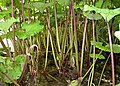
Other river sections that are under nature protection are the natural floodplain above Stühlingen on the border with Switzerland (large stocks of horsetail ) and the area where it flows into the Rhine.
Butterbur population on the Wutach
Butterbur population

Rotten weevil ( Liparus ) on butterbur
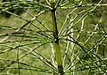
Giant horsetail

Hair snail ( trochulus )

Shell limestone banks in the Gauchach bed

Wutach

Haslach Gorge with Rechenfelsen


Cultural landscape

In terms of its natural landscape, the Wutach is only partly attributable to the Black Forest. The middle Wutachland with the middle and lower Wutach Gorge is already outside. But here, like in the Baar , you see yourself as part of the Black Forest cultural area, not only with regard to tourism. The earlier common affiliation with Baden continues to have an effect. The Wutach Valley Railway is often included in the Black Forest Railway , which is also technically remarkable. The Wutach area below Stühlingen belongs to the Klettgau and the Upper Rhine region.
The Wutach separated in the area of Wutachschlucht the Lake Constance Alemannic dialect area north of the canyon from high Alemannic south. This is particularly evident in the different pronunciation of K . On the northern side it is called Kind und Kuchi (= kitchen), while the south with Chind and Chuchi is linguistically closer to neighboring Switzerland. The locals refer to the people living on the other side of the gorge as Enne-Wiätler , which expresses their belonging to the area beyond (= ennet) the Wutach.
On two short sections of the river - between Grimmelshofen and Eggingen - the Wutach is the border river between Germany and Switzerland.
The economic center of the Wutach area is the city of Waldshut-Tiengen. Important industrial companies in the Wutach Valley are Sto AG (building materials and systems) in Stühlingen and Lauffenmühle (textile production) in Lauchringen. The hydropower of the Wutach is used directly by the Stallegg river power station , and in Wutöschingen with a modern river power station to generate energy. Further energy was and is obtained by deriving it through mill canals , for example with miracle blades from the Hallau water and electricity works , near Stühlingen, the Reuentaler Mühle , in Degernau, in Lauchringen and in Tiengen. The woodworking industry is still important in the Black Forest, even after the Neustadt paper mill was closed in 1989. Between 1624 and around 1760, wood from the area around the Titisee was rafted on the Wutach . It was needed in the earlier iron smelter in Eberfingen .
The first attempt to use the Wutach through a dam to generate energy came in the time of National Socialism . The project to build the Wutachtalsperre , approved in 1943, came to a standstill during the Second World War . In 1951 the Schluchseewerke took up the plans again and greatly expanded them. However, the project aroused widespread protest in the population and was finally rejected in 1960 because of environmental concerns.
Hiking trails
The upper Wutach area (Seebachtal, Titisee, Schluchsee, Hochfirst ) is one of the most important hiking areas in the Black Forest and is therefore criss-crossed with a dense network of hiking trails. The Wutach Gorge is mainly accessible from the following two main routes of the Black Forest Association :
South of the Wutach Gorge, from Grimmelshofen downstream, there are z. There are hiking trails and cycle paths on both sides of the river.
literature
- Geographisch-Kartographisches Institut Meyer (Ed.): Meyers Naturführer - Südschwarzwald Mannheim, 1989 ISBN 3-411-02775-4 .
- Otto F. Geyer et al .: The Upper Rhine regions between Lake Constance and Basel = Geological Guide Collection, 94, Berlin, 2003, ISBN 3-443-15077-2 .
- Dieter Kohlhepp: The Wutach Gorge - picture of a primeval landscape. 3. Edition. Rombach Verlag, Freiburg 1991, ISBN 3-7930-0481-3 .
- State Institute for Environmental Protection (Ed.): The Wutach - Natural history monograph of a river landscape = natural u. Landsch.-Schutzgeb. Baden-Württ., Vol. 6, Karlsruhe, 1988 ISBN 3-88251-135-4 .
- Otti Wilmanns: Black Forest excursion guide - an introduction to landscape and vegetation Stuttgart, 2001 ISBN 3-8252-2180-6 .
Note: Some digital maps show the Wutach erroneously with a course that corresponds to the former Feldberg Danube, probably due to a misinterpretation of the drainage ditch that connects the Schleifebach (Wutach-Nebenbach) with the Aitrach (Danube tributary) and thereby forms a pseudobifurcation .
Web links
- European Water Framework Directive (WFD) - Wutach sub-processing area (PDF file; 1.26 MB)
- Kayak tours on the Wutach
- Till Stumpg (ELMM): Learning module “The Wutach: Did the Rhine ditch the water from the Danube?” (Flash) Geomorphology of southwest Germany. In: WEBGEO regional / Southwest Germany. Institute for Physical Geography (IPG) at the University of Freiburg , accessed on February 1, 2004 .
Individual evidence
- ↑ Günther Reichelt : Geographical land survey: The natural spatial units on sheet 185 Freiburg i. Br. Federal Institute for Regional Studies, Bad Godesberg 1964. → Online map (PDF; 3.7 MB)
- ^ Alfred G. Benzing: Geographical land survey: The natural space units on sheet 186 Konstanz. Federal Institute for Regional Studies, Bad Godesberg 1964. → Online map (PDF; 4.1 MB)
- ↑ Geoportal Baden-Württemberg: LUBW service flowing waters ( Memento of the original from July 21, 2015 in the Internet Archive ) Info: The archive link was inserted automatically and has not yet been checked. Please check the original and archive link according to the instructions and then remove this notice.
- ↑ Web-based information system for Baden-Württemberg: HW outflows
- ^ German Hydrological Yearbook Rhine Region, Part I 2009 State Institute for Environment, Measurements and Nature Conservation Baden-Württemberg, p. 78, accessed on January 22, 2016 (PDF, German, 1.85 MB).
- ↑ Calculated from the annual runoff of the Wutach area, given in: Regional Council Freiburg: WFD, report on sub-processing area "Wutach" , status: May 18, 2005, p. 25
- ↑ Freiburg Regional Council: WFD, report on sub-area “Wutach” , as of May 18, 2005, p. 4
- ↑ a b State Institute for the Environment Baden-Württemberg (LUBW) ( information )
- ↑ Abfluss-BW - a data and map service of the State Office for the Environment Baden-Württemberg ( information )
- ^ Walter Wundt: The mean discharge heights and discharge donations of winter, summer and the year in the Federal Republic of Germany , Remagen, 1958, map supplement
- ↑ Geoportal Baden-Württemberg: LUBW service flowing waters - discharge parameters ( memento of the original dated December 28, 2017 in the Internet Archive ) Info: The archive link was inserted automatically and has not yet been checked. Please check the original and archive link according to the instructions and then remove this notice. As of June 8, 2016
- ↑ Note: natural runoff; the current discharge is reduced to 0.48 m³ / s due to the discharges in the tunnels of the Schluchseewerk.