
Tannheim (Villingen-Schwenningen)
|
Tannheim
City of Villingen-Schwenningen
|
|
|---|---|
 |
|
| Height : | 750-800 m above sea level NN |
| Area : | 1.58 km² |
| Residents : | 1285 (2015) |
| Population density : | 814 inhabitants / km² |
| Incorporation : | January 1, 1972 |
| Postal code : | 78052 |
| Area code : | 07705 |
Tannheim is the southernmost of the eleven districts of Villingen-Schwenningen . The place has about 1285 inhabitants (as of 2015) on an area of 15.79 km² and is located on the Baar on the eastern edge of the Black Forest.
history
First documentary mention
In a document from 817.
The beginnings through to integration
Tannheim was probably already an Alemannic settlement. The place was first mentioned in a document as Tanheim in 817 (St. Gallen Abbey Archives). Initially owned by the St. Gallen Monastery , from the 13th century it belonged to the Fürstenberg rule , from 1684 to the Principality of Fürstenberg , and from 1806 to the Grand Duchy of Baden .
On January 1, 1972, the voluntary integration into the city of Villingen-Schwenningen took place. Tannheim is the southernmost of the eleven city districts.
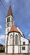
- St. Gallus Church in Tannheim


District
The parish's land extends over 1579 hectares, 949 hectares of which are forest. It reaches an average altitude of 733 m .
Population development
- 1680: 277 inhabitants (52 men, 50 women, 175 children)
- 1950: 743 inhabitants
- 1972: 1092 inhabitants
- 1975: 1080 inhabitants
- 1980: 1171 inhabitants
- 1985: 1235 inhabitants
- 1990: 1189 inhabitants
- 1995: 1234 inhabitants
- 2005: 1386 inhabitants
- 2010: 1342 inhabitants
- 2015: 1285 inhabitants
Village development
Realization of land consolidation (completed in 1982). Continuous filling of existing building gaps in the town center. Preservation of several listed old buildings. 1959 Construction of the town center with school (GHS up to grade 6) and teacher's house (1963). Construction of the multi-purpose hall (1975) and the Catholic clearing center with parish hall (1995). Kindergarten extension 1973.
Infrastructure
Primary school, strengthening through the allocation of pupils from the Herzogenweiler district. A branch of the Volkshochschule Villingen-Schwenningen has been in operation in the town hall since 1973. Tannheim is the seat of the Catholic Educational Institute and has a parish library. The Catholic Clearing House is responsible for over 100 parishes. The outdoor pool is run by the Förderverein Freibad eV
The aftercare clinic has existed since 1996 (family-oriented aftercare for children with heart, cancer and cystic fibrosis).
The Heimatstube was set up in 1995.
Culture in Tannheim
There are many different cultural offers in Tannheim. In this way, the residents can participate culturally in clubs or at festivals.
societies
- Accordion club
- Bildungswerk
- Friends Association of Schools
- Friends of the music band
- Women's community
- Voluntary fire department Tannheim Department
- Freundeskreis Heimatmuseum
- German Red Cross with JRK
- Tannheim youth club
- Bowling club
- Tannheim crawling group
- Country Women's Association
- Shooting club
- Senior Circle
- Table tennis club
- Fools guild.
Individual evidence
- ^ Federal Statistical Office (ed.): Historical municipality directory for the Federal Republic of Germany. Name, border and key number changes in municipalities, counties and administrative districts from May 27, 1970 to December 31, 1982 . W. Kohlhammer, Stuttgart / Mainz 1983, ISBN 3-17-003263-1 , p. 517 .
Web links

Herzogenweiler | Marbach | Mulhouse | Obereschach | Pfaffenweiler | Rietheim | Schwenningen | Tannheim | Villingen | Weigheim | Weilersbach