
Münstertal / Black Forest
| coat of arms | Germany map | |
|---|---|---|

|
Coordinates: 47 ° 51 ' N , 7 ° 47' E |
|
| Basic data | ||
| State : | Baden-Württemberg | |
| Administrative region : | Freiburg | |
| County : | Breisgau-Upper Black Forest | |
| Height : | 524 m above sea level NHN | |
| Area : | 67.73 km 2 | |
| Residents: | 5110 (Dec. 31, 2018) | |
| Population density : | 75 inhabitants per km 2 | |
| Postal code : | 79244 | |
| Primaries : | 07636, 07602 | |
| License plate : | FR | |
| Community key : | 08 3 15 130 | |
| Address of the municipal administration: |
Wasen 47 79244 Münstertal |
|
| Website : | ||
| Mayor : | Rüdiger Ahlers (SPD) | |
| Location of the municipality of Münstertal / Black Forest in the Breisgau-Hochschwarzwald district | ||
  |
||

Münstertal / Schwarzwald is a municipality in the Black Forest , which is about 20 kilometers south of Freiburg im Breisgau .
geography
location
The Münstertal extends from Staufen im Breisgau up into the Black Forest. It divides into several side valleys and extends in the direction of Belchen , over the district of Stohren in the direction of Freiburg's local mountain Schauinsland and over the Münsterhalde in the direction of Badenweiler. The altitude of Münstertal extends from 380 m to 1414 m on the Belchen summit and thus has a height difference of 1060 meters.
Community structure

View from Belchen to Untermünstertal

Overlooks the Munster Valley from Mount Köpfle from
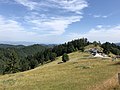
Almgasthof Kälbelescheuer

.jpg)

Münstertal / Black Forest consists of the formerly independent communities of Obermünstertal and Untermünstertal with a total of 65 villages, hamlets, Zinken, farms and houses.
The towns of Breitmatt, Diezelbach, Hasengrund, Laisacker (hof), Landensberg, Langenbach, Lehengasse, Limberg, Rammelsbach, Sägerstraße (Sägegasse), Sirnitz, Sirnitzgrund, Wildsbach and the towns of Fischmatte, Gufenbach, which were dissolved in 1960, are located in the Untermünstertal part of the municipality , Hinterer Rotenbuck, (outside) courtyard, (middle) courtyard, (above) courtyard, Kaltwasser, Mulden, Münster (left side of the street), Münster (right side of the street), Neuhäuser (left side of the street), Neuhäuser (right side of the street), Prestenberg-Lehn , Süßenbrunn, Vorderer Rotenbuck, Wasen (above), Wasen (below) and Ziegelplatz.
Coats of arms of the municipality

Obermünstertal

Untermünstertal


history
The village of Münster was mentioned as early as 1258 and gave the valley its name. In 1346 it was destroyed by the Counts of Freiburg .
On December 1, 1971, the independent municipalities of Obermünstertal and Untermünstertal merged to form the municipality of Münstertal / Black Forest.
politics

Municipal council
The local election on May 26, 2019 resulted in the following distribution of the 14 seats in the local council:
| list | Share of votes | Seats |
| CDU | 41.5% | 6 (± 0) |
| SPD | 27.7% | 4 (- 1) |
| FWG | 30.8% | 4 (+ 1) |
mayor
- 1991-2007: Peter Jehle (CDU)
- since 2007: Rüdiger Ahlers (SPD)
coat of arms
Blazon : In silver (white) a lowered red coat of arms with a silver (white) bar, floating above a red miter with red decorative ribbons, accompanied by two diagonally crossed black mallets and iron.
The coat of arms was awarded in 1972 by the Ministry of the Interior of the State of Baden-Württemberg to the municipality that was newly formed one year earlier. Its depiction ties in with the history of the place: the miter stands for the St. Trudpert Monastery , whose manorial rule was the Münstertal until 1806. The binding shield indicates the role of the Habsburgs as chief bailiffs. Mallets and irons are a reminder of the importance of mining in the municipality, which lasted until the 18th century.
Partner municipality
Münstertal maintains a partnership with Rittersgrün in the Erzgebirge , which is now part of the municipality of Breitenbrunn / Erzgeb. heard.
Economy and Infrastructure
tourism
The Münstertal is a rural community. Tourism is managed by the tourist office founded in 1935.
In the district of Diezelbach there is a large campsite that is open all year round.
traffic

Münstertal is connected to the national rail network by the Münstertalbahn to Bad Krozingen . The railway is operated by the Südwestdeutsche Verkehrs-AG . The electrification of the line has been completed and the electric train operation officially started on September 21, 2013. Road 130 leads south to Haldenhof, an intermediate pass of the Sirnitz Pass .
Culture and sights


Museums
- In the Black Forest House 1902 (formerly: the Kaltwasserhof ), in which the ARD series of the same name was filmed, which received the Adolf Grimme Prize in 2003 , there is a museum that reports on both television production and life on the mountain farm.
- The apiculture museum is known far beyond the borders of Baden and reports on the coexistence of humans with bees from the beginnings in the Stone Age to the present. It is the largest of its kind in Europe.
- The Teufelsgrund visitor mine reports on the mining tradition of the Black Forest. In the Middle Ages, silver was mined here, which brought great wealth to the then city of Münster. River spar and barite were mined until 1958 . In the previous centuries, lead ores were predominantly extracted, some of which were further processed on site in the Münstertal. The mine now has an asthma therapy tunnel, in which respiratory diseases and skin conditions are treated.
- The museum for mining, forest and settlement history located in the town hall provides information about the tradition and history of the Munster valley.
Buildings
The Benedictine monastery of St. Trudpert was founded in the 9th century. For a long time, the monastery was the center of the village and the starting point for the Christianization of the southern Black Forest. Today the mother house of the Sisters of St. Joseph stands here. The ruins of Scharfenstein Castle are in the Obermünstertal district .
Deer sculpture
On the L 130 between the districts of Rotenbuck and Münsterhalden, strangers erected a life-size deer sculpture on a rock on the night of May 1, 2016.
Personalities
- Willibald Strohmeyer (1877–1945), Catholic clergyman, pastor of St. Trudpert in the Münstertal, was murdered in Münstertal at the end of the Second World War
- Franz Gutmann (* 1928), sculptor, honorary citizen of the community since March 2019
- Otmar Gutmann (1937–1993), filmmaker
- Karl-Josef Fuchs (* 1960), cook
- Karl Pfefferle (1918–2009), German beekeeper and author
- Maren Wiesler (* 1993), German ski racer
- Klara Bühl (* 2000), German soccer player
literature
- André Bechtold: The mining town of Münster and the formation of the Habsburg rule on the Upper Rhine in the 14th and 15th centuries. In: Das Markgräflerland , Volume 2/2003, Schopfheim 2003, pp. 81–91.
- Korinna Thiem: Historical landscape analysis as a method for river assessment using the example of the Münstertal in the Black Forest . (= Culterra; 46). University of Freiburg, Freiburg im Breisgau 2006
Individual evidence
- ↑ State Statistical Office Baden-Württemberg - Population by nationality and gender on December 31, 2018 (CSV file) ( help on this ).
- ↑ http://www.schwarzwald-geniessen.de/de/orte/M%FCnstertal
- ^ The state of Baden-Württemberg. Official description by district and municipality. Volume IV: Freiburg District Kohlhammer, Stuttgart 1978, ISBN 3-17-007174-2 , pp. 167–169
- ↑ Bernd Ottnad: The political history from the beginnings to the present in: District Breisgau-Hochschwarzwald (Ed.): Breisgau-Hochschwarzwald. Land from the Rhine via the Black Forest to the Baar , Karl Schillinger, Freiburg im Breisgau 1980, ISBN 3-921340-44-6 , p. 125
- ^ Federal Statistical Office (ed.): Historical municipality directory for the Federal Republic of Germany. Name, border and key number changes in municipalities, counties and administrative districts from May 27, 1970 to December 31, 1982 . W. Kohlhammer, Stuttgart / Mainz 1983, ISBN 3-17-003263-1 , p. 499 .
- ↑ State Statistical Office Baden-Württemberg, municipal council elections 2019: Münstertal / Black Forest , accessed on July 17, 2019
- ^ Leo-bw - The coat of arms of Münstertal / Black Forest , accessed on July 17, 2019
- ^ Staufen: Photos: Opening of the electrified Münstertalbahn - Photo galleries - badische-zeitung.de. Retrieved September 22, 2013 .
- ↑ Manfred Lange: Münstertal: Life-size animal figure: The Münstertal now also has a deer jump. Badische Zeitung, May 2, 2016, accessed on February 26, 2017 .
Web links
- Teufelsgrund visitor mine
- Link catalog on Münstertal at curlie.org (formerly DMOZ )
- Landesarchiv Baden-Württemberg, local lexicon : Münstertal / Black Forest on www.leo-bw.de, 2019