
Vogtsburg in the Kaiserstuhl
| coat of arms | Germany map | |
|---|---|---|

|
Coordinates: 48 ° 6 ' N , 7 ° 37' E |
|
| Basic data | ||
| State : | Baden-Württemberg | |
| Administrative region : | Freiburg | |
| County : | Breisgau-Upper Black Forest | |
| Height : | 218 m above sea level NHN | |
| Area : | 37.36 km 2 | |
| Residents: | 6031 (Dec. 31, 2018) | |
| Population density : | 161 inhabitants per km 2 | |
| Postal code : | 79235 | |
| Area code : | 07662 | |
| License plate : | FR | |
| Community key : | 08 3 15 133 | |
| LOCODE : | DE VOG | |
| City structure: | 7 districts | |
City administration address : |
Bahnhofstrasse 20 79235 Vogtsburg im Kaiserstuhl |
|
| Website : | ||
| Mayor : | Benjamin Bohn | |
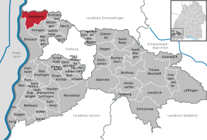
| Location of the town of Vogtsburg in the Kaiserstuhl in the Breisgau-Hochschwarzwald district | ||
  |
||

Vogtsburg im Kaiserstuhl is a city in the Kaiserstuhl , located in the middle of the Upper Rhine Plain in Baden-Württemberg and forms the northwestern part of the Breisgau-Hochschwarzwald district . The town of Vogtsburg, which emerged from the municipal reform in Baden-Württemberg , was created in the 1970s through incorporations and amalgamation of seven Kaiserstuhl communities and has around 5600 inhabitants. With 1,400 hectares of vineyards, Vogtsburg is the largest wine-growing community in Baden-Württemberg.
geography
Geographical location

With the exception of Burkheim, the individual villages of Vogtsburg are embedded in the valleys of the inner Kaiserstuhl. The horseshoe-shaped main ridge of the Kaiserstuhlgebirge, which opens to the west, essentially forms the outer boundary of Vogtsburg, which is marked in the west by the Rhine, here borders on Alsace and thus on France .
geology
The Kaiserstuhl Mountains were created by massive fractional tectonic events that were shaped to a much smaller extent by volcanic activities. The loess layers, which are up to 30 meters thick, form another striking geological feature and, in addition to the climate, are partly responsible for the high fertility of the area.
climate
The relatively low altitude and the sheltered location by the Vosges and the Black Forest promote the almost Mediterranean micro-climate.
| Vogtsburg 2000-2008 | ||||||||||||||||||||||||||||||||||||||||||||||||
|---|---|---|---|---|---|---|---|---|---|---|---|---|---|---|---|---|---|---|---|---|---|---|---|---|---|---|---|---|---|---|---|---|---|---|---|---|---|---|---|---|---|---|---|---|---|---|---|---|
| Climate diagram | ||||||||||||||||||||||||||||||||||||||||||||||||
| ||||||||||||||||||||||||||||||||||||||||||||||||
|
Average monthly temperatures and precipitation for Vogtsburg 2000–2008
Source: [2]
|
||||||||||||||||||||||||||||||||||||||||||||||||||||||||||||||||||||||||||||||||||||||||||||||||||||||||||||||||||||||||||||||||||||||||||||||||||||||
Protected areas, nature

There are 14 nature reserves in the municipality of Vogtsburg im Kaiserstuhl :
- 3049- Büchsenberg ,
- 3069- Rheinhalde Burkheim ,
- 3076- Badberg ,
- 3096- Ohrberg ,
- 3103- Schneckenberg ,
- 3104 Disc Bucket Blood Buck ,
- 3125- Bitzenberg ,
- 3146- Casting Rappennest ,
- 3148- Badger Holes Buck ,
- 3148- Ebnet ,
- 3152- Haselschacher Buck ,
- 3178- Niederrotweil quarry ,
- 3183- Oberbergener Scheibenbuck and
- 3283- Schelinger Weide-Barzental .
In addition, the landscape protection area
- 3.15.011 Rhine floodplain forests .
Parts of the urban area belong to the FFH areas
- 7911-341 Kaiserstuhl
- 7911-342 Rhine valley from Breisach to Sasbach
and also to the bird sanctuaries
- 7911-401 Rhine lowland Breisach-Sasbach with Limberg
- 7912-442 Kaiserstuhl
Neighboring communities
| Artzenheim ( Alsace ) |
Sasbach Endingen |
Bahlingen |
| Baltzenheim (Alsace) |
.svg)
|
Eichstetten |
| Breisach | Your singing | Boetzingen |
The communities Artzenheim and Baltzenheim belong to the French department of Haut-Rhin , Sasbach, Endingen and Bahlingen belong to the district of Emmendingen , the other communities to the district of Breisgau-Hochschwarzwald .
history
Even if the city of Vogtsburg is one of the youngest cities in Germany, the individual districts look back on a history that is usually more than a thousand years old. The earliest finds in Oberbergen can be assigned to the band ceramists (around 5500-4950 BC) from the Neolithic Age .
In Bischoffingen there are sites that point to late Neolithic corded ceramists (around 2800–2200 BC). Further excavations uncovered graves dating from the cultural and historical epoch of the Bronze Age 1700–1200 BC. Be assigned. In more recent early history from around 800 BC. There are numerous references to a dense settlement of the Celts , which reach up to the advance of the Alemanni around 200 AD. For example, Oberbergen is the most important settlement area in South Baden during the Hallstatt period .
Today's city was created on January 1, 1975 under the name Oberrotweil through the merger of the city of Burkheim and the communities of Achkarren, Bischoffingen and Oberrotweil. At the same time, the two communities Bickensohl and Schelingen were incorporated into Oberrotweil. As early as January 1, 1973, Oberbergen was incorporated into Oberrotweil.
On April 15, 1977 the name of the city was changed to Vogtsburg in the Kaiserstuhl .
Due to the horseshoe shape of the Kaiserstuhl, which is only open to the west towards the Rhine, Vogtsburg was not easy to reach before the breakthrough of the car as a means of mass transport. This has led to a stagnation of the population since 1870. The total population from 1880 to 1980 was stable at 5000 people. During this time there was great emigration. Only since 1980 has the population increased again due to new development areas.
See also: Castle Bickensohl , castle Bischoffingen , ruin Burkheim , Höhingen Castle
Districts

Vogtsburg consists of nine individual villages. Before the merger, Oberrotweil and Niederrotweil had already formed a community. The small hamlet originally named Vogtsburg belongs to Oberbergen. For these reasons, the city consists of nine localities, but only seven political districts. The town charter was transferred to the entire municipality of Vogtsburg von Burkheim.
- Coats of arms of the districts


- Aerial photos of the districts

Achkarren , with remains of Höhingen Castle

Bickensohl , lies below the skull

Burkheim , with castle ruins
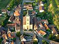
Oberrotweil , central location, seat of the city administration

Niederrotweil, politically belongs to Oberrotweil
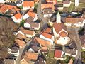
Schelingen , the highest village in Vogtsburg

Alt-Vogtsburg, politically belongs to Oberbergen


politics

town hall
The town hall and the municipal administration are located in Oberrotweil.
Municipal council
The municipal council consists of the elected voluntary councilors and the mayor as chairman. The mayor is entitled to vote in the municipal council.
In Vogtsburg in the Kaiserstuhl, the municipal council is elected according to the procedure of the false partial choice. The number of local councils can change due to overhang mandates . The municipal council in Vogtsburg now has 22 members (2014: 23). The local elections on May 26, 2019 led to the following official final result:
| Parties and constituencies | 2019 | 2014 | 2009 | |||||
| % | Seats | % | Seats | % | Seats | |||
| FW | Free voters | 55.4 | 12 | 55.9 | 13 | 60.1 | 13 | |
| CDU | Christian Democratic Union of Germany | 44.6 | 10 | 44.1 | 10 | 39.9 | 9 | |
| total | 100 | 22nd | 100 | 23 | 100 | 22nd | ||
|---|---|---|---|---|---|---|---|---|
| voter turnout | 68.9% | 60.3% | 62.8% | |||||
mayor
Benjamin Bohn from Burkheim has been the mayor since the mayoral election in 2015. In the second ballot on April 12, 2015, he was elected with 72.05% of the valid votes. He replaced Gabriel Schweizer, who had been mayor for 24 years and received approval from 97.6% of the citizens in the 2007 election.
Partnerships
The village of Burkheim has been on friendly terms with the Alsatian municipality of Sigolsheim on the Alsace Wine Route since 1967 .
Economy and Infrastructure
In addition to wine , a lot of fruit is grown here, especially cherries , plums and apples . In addition to agriculture, tourism is becoming increasingly important. The largest company in town is the Bischoffingen wine cooperative . The largest solar park in Baden-Württemberg has been located in Vogtsburg since February 2013 .
traffic
In the western part of the municipality, the L113 Breisach - Riegel - Freiamt runs - without passing through the village - which meets the L115 Rotweil - Bötzingen - Umkirch at the level of Niederrotweil . The individual districts are connected by district roads. Several districts are located on the Kaiserstuhlbahn .
dishes
The area of the city of Vogtsburg belongs to the district of the district court of Breisach .
education
In Vogtsburg there is a primary and secondary school (Werkrealschule) Oberrotweil, Burkheim branch, Oberbergen primary school, Achkarren branch as well as six kindergartens, a Waldorf kindergarten in Burkheim and a crèche in Oberrotweil. At secondary schools there is a secondary school and a grammar school in neighboring Breisach.
Local public transport
Achkarren, Oberrotweil and together Burkheim and Bischoffingen each have a stop on the western Kaiserstuhlbahn from Breisach to Riegel. The train has rather sporadic train traffic throughout the day, but not a complete cycle.
In addition, Vogtsburg is served by several bus routes between Breisach and Endingen and another via Bötzingen to Freiburg. The entire local traffic is part of the regional transport network Freiburg .
shipping
Although Burkheim is on the Rhine , there is no Rhine port of its own - however, there is a landing stage for the shipment of gravel at the level of Burkheimer Baggersee.
Culture and sights
Museums
In 1979, the Kaiserstuhl Wine Museum was opened in Achkarren in the historic Zehntscheuer. The building was named “St. Johannser Trotte ”mentioned. In Burkheim there is the Kaiserstuhl corkscrew museum.
Buildings
Thanks to the districts of Achkarren, Oberrotweil, Schelingen and Altvogtsburg, Vogtsburg has four Weinbrenner- style churches .
The St. Michaels Church in Niederrotweil was first mentioned in 1175 (according to Dehio even in 1157), but it is much older. According to Reclam's art guide, it could date from the 8th century. Is aware of this building because of its only in 1951 exposed frescoes from the mid-14th century, but especially because of the carved wooden altar, a late work of Master H. L . The altar is considered an outstanding example of the late Gothic and is dated to around 1530. The organ, built in 1758 and located in this church since 1833, is the oldest surviving organ in Breisgau.

The St. Romanuskirche in Altvogtsburg was built in 1835/36 as a branch church directly on Landstrasse. The plan initially provided for a church for 700 people, but was revised by the district master builder Hans Voss and adapted to the size of the community, i.e. reduced in size. The hall building has a choir and two side rooms. The high altar comes from the workshop of Franz Xaver Marmon , the windows from the Freiburg glass workshop Helmle & Merzweiler . The interior, which was initially only given a light coat of paint, was given a historicist design from 1883 and decorated with ornamental pictures, wall paintings and stylized tendrils by the Freiburg painter Anselm Endress . After both the building structure and the furnishings were threatened due to the ingress of water and the building structure was severely damaged, not least because of vibrations from traffic on the nearby street and light earthquakes, the church had to be closed. The German Foundation for Monument Protection is committed to saving the church.
The parish church in Schelingen was planned by Christoph Arnold , a nephew and student of Friedrich Weinbrenner.
The old town of Burkheim is entered through the city gate; it consists essentially of the development of a single cobbled street and is extremely romantic and idyllic. At the end of the town, the old castle ruins stand on the mountain spur, below which the river bed ran before the Rhine was straightened.
Remains of the ruins of Höhingen Castle can still be found above the Achkarren on the Schlossberg .
Church and monastery “St. Peter on the Kaiserstuhl ”of the Pauline Order , which was located on the Neunlindenbuck near the skull. The small monastery existed since at least 1373. Little is known, but the monastery may not have survived the Reformation, so that one has to assume the end for the 16th century.
Sports
Cycling : Traditionally, the final round course (king's stage) of the international regional tour took place in Vogtsburg .
Personalities
sons and daughters of the town
- Eugen Biser (1918–2014), religious philosopher
Other personalities
- Jörg Wickram (around 1505 – before 1562), early New High German writer, became town clerk in Burkheim around 1555 .
- Lazarus von Schwendi (1522–1583), diplomat, statesman and imperial general, from 1560 lord of Burkheim am Kaiserstuhl with Oberrotweil, Oberbergen, Vogtsburg and Jechtingen.
- Simone Larsen (* 1970), grew up in Bischoffingen, German-Norwegian pop singer
- Erik Wolf (1902–1977), legal philosopher and canon lawyer, lived in Oberrotweil since 1959 and is also buried here.
Web links
- Official homepage of the city of Vogtsburg im Kaiserstuhl
- Kaiserstuhl Tourism: Vogtsburg
- The churches of Achkarren , Alt-Vogtsburg , Oberrotweil and Schelingen on the private architecture website "Baukunst Baden" (badischewanderungen.de)
- Vogtsburg and nature on Badberg and in the inner Kaiserstuhl
Individual evidence
- ↑ State Statistical Office Baden-Württemberg - Population by nationality and gender on December 31, 2018 (CSV file) ( help on this ).
- ^ Federal Statistical Office (ed.): Historical municipality directory for the Federal Republic of Germany. Name, border and key number changes in municipalities, counties and administrative districts from May 27, 1970 to December 31, 1982 . W. Kohlhammer, Stuttgart / Mainz 1983, ISBN 3-17-003263-1 , p. 509 .
- ^ Federal Statistical Office (ed.): Historical municipality directory for the Federal Republic of Germany. Name, border and key number changes in municipalities, counties and administrative districts from May 27, 1970 to December 31, 1982 . W. Kohlhammer, Stuttgart / Mainz 1983, ISBN 3-17-003263-1 , p. 496 .
- ^ Federal Statistical Office (ed.): Historical municipality directory for the Federal Republic of Germany. Name, border and key number changes in municipalities, counties and administrative districts from May 27, 1970 to December 31, 1982 . W. Kohlhammer, Stuttgart / Mainz 1983, ISBN 3-17-003263-1 , p. 510 .
- ^ Vogtsburg im Kaiserstuhl - Final results of the 2019 municipal council election , accessed on July 18, 2019
- ^ Benjamin Bohn : Vogtsburg: 31,104 solar modules on 14 hectares: Hike through the largest solar park in the country , Badische Zeitung, February 24, 2013, accessed on March 29, 2013
- ↑ St. Michael - official website of the church with numerous photos
- ^ Badische Zeitung, April 19, 2008
- ^ Pauline monastery St. Peter on the Kaiserstuhl / Vogtsburg in the database of monasteries in Baden-Württemberg of the Baden-Württemberg State Archives
- ↑ Bertram Jenisch; Thomas Steffens: The forgotten St. Peters monastery on the Kaiserstuhl . In: Schau-ins-Land: Annual issue of the Breisgau-Geschichtsverein Schauinsland 122/2003, pp .: 51 ff. ( Online )