
Sölden (Black Forest)
| coat of arms | Germany map | |
|---|---|---|

|
Coordinates: 47 ° 56 ' N , 7 ° 49' E |
|
| Basic data | ||
| State : | Baden-Württemberg | |
| Administrative region : | Freiburg | |
| County : | Breisgau-Upper Black Forest | |
| Height : | 394 m above sea level NHN | |
| Area : | 3.8 km 2 | |
| Residents: | 1274 (December 31, 2018) | |
| Population density : | 335 inhabitants per km 2 | |
| Postal code : | 79294 | |
| Area code : | 0761 | |
| License plate : | FR | |
| Community key : | 08 3 15 107 | |
| Community structure: | 2 districts | |
| Address of the municipal administration: |
Staufener Strasse 4 79294 Sölden |
|
| Website : | ||
| Mayor : | Markus Rees | |
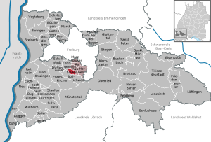
| Location of the municipality of Sölden in the Breisgau-Hochschwarzwald district | ||
  |
||


Sölden (Alemannic Sailede ) is a municipality in the Breisgau-Hochschwarzwald district , just under ten kilometers south of Freiburg im Breisgau .
geography
location
Located between the Schönberg-Hohfirst area and the Black Forest in Hexental , Sölden belongs to the so-called Vorbergzone as well as to the Black Forest, as the main fault between the Upper Rhine Graben and the Black Forest runs through the municipality . According to the height above sea level, the hilly community extends from the lowest point at 318 m to 732 m above sea level. NN .
Community structure
The village of Sölden and the Zinken Gaisbühl belong to the municipality of Sölden.
Neighboring communities
Sölden borders in the north-west on the municipality of Ebringen , in the north-east on Wittnau and in the south on Bollschweil .
history
Sölden was first mentioned in a document in 805 AD as Marca Selidon .
The monastery
Around 1087 the prior Ulrich von Zell (1080s – 1093) relocated the Cluniazenic priory Grüningen to Zell im Möhlintal , later called Ortisei . In the vicinity of this monastery, in Bollschweil , Ulrich founded a community of nuns a short time later, which was moved to Sölden in the Black Forest Hexental in 1115. As a priory, Sölden was directly subordinate to the Cluny Abbey , but the de facto priory of Ortisei exercised the overall supervision. About 13 to 20 nuns lived in this monastery at that time under the direction of a provost who was appointed by the mother monastery of Cluny. After a fire in the church and monastery in 1468, the monastic order fell apart, and around 1500 there was no longer a women's convent in Sölden . From 1546/1547 the provost's office was administered by the St. Georgen Monastery and in 1560 passed to the St. Peter Abbey , to which it was finally incorporated in 1598. During the Thirty Years War the church burned again. After another fire in 1746, the Gothic church was redesigned in Baroque style. The secularization of 1807 also affected the spiritual community in Sölden and led to the abolition of the monastery.
The Sölden manor was not particularly extensive and concentrated in Breisgau , the (umbrella) bailiwick was connected with that of the St. Ulrich priory.
Sölden is a member of the Fédératon des Sites Clunisiens , a European association of places associated with the history of the Cluny Monastery.
- Provosts of Sölden
|
|
Population development
| year | 1871 | 1939 | 1961 | 1970 | 1995 | 2005 | 2010 | 2015 |
| Residents | 327 | 381 | 611 | 813 | 1088 | 1191 | 1167 | 1281 |
(Information provided by the municipality)
politics

Municipal council
The municipal council of Sölden has 10 seats. The mayor is an additional member and chairman with voting rights.
- After the local elections on May 25, 2014 , with a turnout of 68.0% (2009: 64.2%), the Sölden Citizens 'List (56.4%) again received six seats and the Independent Citizens' List (43.6%) again received four seats .
- After the local elections on May 26, 2019 , with a turnout of 78.7%, the Sölden citizens' list (share of the vote 54.8%) received five seats, the Greens (27.8%) three seats and the CDU (17.4%) two Seats.
mayor
On April 19, 2009, in the second ballot, Markus Rees was elected mayor in the second ballot with 51.76 percent of the valid votes cast and a turnout of 67.42 percent. He received 22 votes more than his competitor Michael Baumann, who received 48.24 percent of the votes cast. On March 12, 2017, he was confirmed in office with 81 percent of the valid votes.
Administrative community
The municipality is a member of the Hexental administrative community , which also includes the municipalities of Merzhausen (headquarters of the VG), Au , Horben and Wittnau.
religion
About 73% of the population belong to the Catholic Church . The parish of St. Fides and Markus has belonged to the pastoral care unit “Upper Möhlintal” since 2006, along with seven other parishes; about 16% of the people of Sölden are Protestant and belong to the parish of Merzhausen; the rest belong to other denominations or are non-denominational .
Culture and sights


Buildings
The church of St. Fides and Markus , the priory and the connecting structure between them have been preserved from the medieval-baroque monastery complex . Since 2001 the administration center of the village helpers organization Sölden eV has been housed in the former priory .
On the 456 m high Saalenberg (also Salenberg) stands the Saalenberg Chapel, built in 1875, for the painful mother of God . From there you have a good view over the Hexental.
leisure
The historic beggar path , a national hiking trail from Merzhausen / Freiburg to Badenweiler (more than 30 km) also runs through Sölden.
Economy and Infrastructure
The municipality, which was once dominated by agriculture, now only has a full-time farm , with seven farmers doing farming as a sideline. Around 400 people commute to work in Freiburg and the surrounding area. The community has a primary school with a multi-purpose hall, kindergarten and fire station .
State road 122, which runs through the Hexental and connects Freiburg with Kirchhofen , runs through the village . There is also a bus from Südbadenbus GmbH (SBG) with connections to Freiburg and Bad Krozingen .
Personalities
Sons and daughters of the church
- Heinrich Gassert (1857–1928), doctor and poet
- Franz Kern (1925–2012), priest and local history researcher
Honorary citizen
In 1963, Franz Kern was made an honorary citizen for his services to his home community .
literature
- Florian Lamke: Cluniacensians on the Upper Rhine. Conflict resolution and noble group formation in the time of the investiture dispute. Freiburg / Munich 2010, ISBN 978-3-495-49954-2 , especially pp. 239-272.
- Michael Buhlmann: Benedictine monasticism in the medieval Black Forest. A lexicon. Lecture at the Black Forest Association St. Georgen eV, St. Georgen im Schwarzwald, November 10, 2004, Part 2: NZ. (= Vertex Alemanniae, H. 10/2), St. Georgen 2004, p. 96f.
- Wolfgang Müller (arrangement): Sölden. In: Franz Quarthal (arrangement): The Benedictine monasteries in Baden-Württemberg. (= Germania Benedictina. Volume 5). Ottobeuren 1976, ISBN 3-8043-0070-7 , pp. 599-604.
- Wolfgang Stülpnagel (arrangement): Sölden. In: Handbook of the historical sites of Germany . Volume 6: Baden-Württemberg. (= Kröner Tb 276). 2nd Edition. Stuttgart 1980, ISBN 3-520-27602-X , pp. 747f.
- Franz Kern : Sölden. The story of a small village. Solden 1995, OCLC 312536883 .
Web links
- Official website
- Sölden in Hexental at freiburg-schwarzwald.de
- History of the Sölden monastery at kloester-bw.de
Individual evidence
- ↑ State Statistical Office Baden-Württemberg - Population by nationality and gender on December 31, 2018 (CSV file) ( help on this ).
- ^ The state of Baden-Württemberg. Official description by district and municipality. Volume IV: Freiburg administrative region. Kohlhammer, Stuttgart 1978, ISBN 3-17-007174-2 , pp. 135-136.
- ^ Friedrich Hefele: Freiburg document book. Volume 1, p. 154, document no.182.
- ^ Result of the 2014 local elections in Sölden ( Memento from March 5, 2016 in the Internet Archive ), Badische Zeitung , May 25, 2014.
- ↑ State Statistical Office Baden-Württemberg - Preliminary results of the 2019 municipal council elections in Sölden , accessed on November 14, 2019.
- ↑ State Gazette No. 15 of April 24, 2009, p. 11.
- ^ State gazette for Baden-Württemberg - Mayoral election of Sölden , accessed on November 14, 2019.
- ↑ Freiburg-Schwarzwald.de: Saalberg above Sölden, Chapel in Hexental at Freiburg. Retrieved December 26, 2013 .