Schelingen
|
Schelingen
City of Vogtsburg in the Kaiserstuhl
|
|
|---|---|
| Coordinates: 48 ° 6 ′ 15 ″ N , 7 ° 40 ′ 59 ″ E | |
| Height : | 310 m |
| Area : | 4.1 km² |
| Residents : | 334 (Dec. 31, 2004) |
| Population density : | 81 inhabitants / km² |
| Incorporation : | 1st January 1975 |
| Postal code : | 79235 |
| Area code : | 07662 |
|
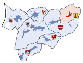
Location of Schelingen
in the town of Vogtsburg am Kaiserstuhl |
|
Schelingen is a winegrowing village in the Kaiserstuhl in southwest Germany. About 340 people live in Schelingen.
On January 1, 1975, Schelingen was incorporated into the town of Oberrotweil, whose name was changed on April 15, 1977 to Vogtsburg im Kaiserstuhl .
Schelingen is the easternmost village of Vogtsburg in the center of the Kaiserstuhl. To the west lies Oberbergen, which is connected via Schelingen on a district road to Bahlingen, five kilometers to the east, in the district of Emmendingen .
The agricultural village lives mainly from viticulture. The vineyard area is about 61 hectares.
The Catholic Church of St. Gangolf was built in the Weinbrenner style in 1825; the architect was Christoph Arnold , a student of Friedrich Weinbrenner .
To the south of the village lies the 435 m high, round-domed Badberg , which is completely covered with grass . There, in the nature reserve of 42 ha you will find an extremely rare in Germany flora and fauna .
Individual evidence
- ^ Federal Statistical Office (ed.): Historical municipality directory for the Federal Republic of Germany. Name, border and key number changes in municipalities, counties and administrative districts from May 27, 1970 to December 31, 1982 . W. Kohlhammer, Stuttgart / Mainz 1983, ISBN 3-17-003263-1 , p. 509 f .


