
Knight green
|
Knight green
Municipality of Breitenbrunn / Erzgeb.
|
||
|---|---|---|
 |
||
| Height : | 628 m above sea level NN | |
| Area : | 21.88 km² | |
| Residents : | 1610 (May 9, 2011) | |
| Population density : | 74 inhabitants / km² | |
| Incorporation : | January 1, 2007 | |
| Postal code : | 08359 | |
| Area code : | 037757 | |
Location of Rittersgrün in Saxony |
||
 Rittersgrün seen from Taubenfels
|
||

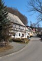
Rittersgrün is a district of the municipality of Breitenbrunn / Erzgeb. in the Saxon Erzgebirgskreis . The scattered settlement with around 1,600 inhabitants developed around several hammer mills that operated from the 15th to the 19th century on the course of the Pöhlwasser and were supplied with ores from numerous surrounding mines. Due to its location on an important Erzgebirge pass , the settlement was in the Thirty Years Warrepeatedly plundered by passing mercenaries. After the demise of hammer mills in the middle of the 19th century, cardboard and sawmills dominated the municipality's economy. In 2007 Rittersgrün moved to Breitenbrunn / Erzgeb. incorporated. Today Rittersgrün is best known as an excursion and winter sports destination. The main attractions include the Saxon narrow-gauge railway museum and a well-developed network of hiking trails.
geography
Geographical location
Rittersgrün extends from northwest to southeast in the valley of the Pöhlwasser , about seven kilometers south of the large district town of Schwarzenberg , at an altitude of up to 820 meters. Located on the Rittersgrüner Pass , which has been actively used since the 16th century , the settlement is flanked to the west by the 792-meter-high Hirtenberg and the Kohlung to the south , and to the east by the 700-meter-high Sonnenberg and the 836-meter-high Ochsenkopf . State road 271 runs through the village from Raschau to Oberwiesenthal , into which a connecting road from Breitenbrunn, about 2.5 kilometers away, joins. The border to the Czech Republic runs south of the town hall , through which border crossings for ski hikers, pedestrians and cyclists lead.
Type of settlement
Rittersgrün is not one of the typical Waldhufendörfer in the Ore Mountains , as the rocky subsoil hardly allowed agriculture. The starting point for the settlement of the valley section formed the hammer mills located on the Pöhlwasser . While the houses on the left side of the river are mostly grouped along the S 271, the scattered settlement on the Hammerberg above the former Rothenhammer forms the core of the settlement on the opposite side.
Community structure

The political municipality of Rittersgrün was not created until 1856 through the merger of the municipalities of Oberrittersgrün , Unterrittersgrün and Rothenhammer Rittersgrün in the Schwarzenberg court office . The Ehrenzipfel group of houses, which was probably built in the 17th century , has always belonged to Rittersgrün. In 1921 the previously independent Arnoldshammer manor district went to Rittersgrün. Oberglobenstein was incorporated as early as the middle of the 19th century, and in 1978 all of Globenstein was given to Rittersgrün. In 1994 Tellerhäuser followed with the district of Zweibach . Today only Rittersgrün and Tellerhäuser are designated as districts of Breitenbrunn under municipal law.
geology
Rittersgrün is located in the southwest of the Ore Mountains, which were formed in the Paleozoic Era , a few kilometers from the highest point in Saxony, the Fichtelberg . The ore deposits around Rittersgrün formed the basis for the mining development of the community. In the pits at Upper and Lower Globe stone were magnetite - skarns with tin contents and non-ferrous metal -Magnetit-skarns in andalusitführenden muscovite - schist mined. Magnetic iron ore, zinc blende and limestone were mined in a forest on the Hirtenberg . The slope of the Hirtenberg is covered with wooded and grass-covered weathered soils of light-colored mica slate . In the Rothen-Adler tunnel in the southeastern area of the settlement known as Hammerberg above the Rothenhammer , red iron stone that had emerged from the original magnetic iron stone was mined; pyroxene , calcite , fluorspar and brown spar also occurred . Mighty mica slate rocks form the summit of the Ochsenkopf . At the Sonnenberg, a non-ferrous metal skarn with magnetite guides and tin content was used to build. The ore minerals included zinc blende, copper gravel , magnetic gravel and magnetic iron ore.
climate
Due to its height, the temperatures in Rittersgrün are below those of the lower-lying communities in the area all year round. In the winter months, the higher areas of Rittersgrün are often covered with snow for a long time. The annual average rainfall of 1024.4 mm is roughly at the level of Oberwiesenthal (1058.7 mm), well above the values of the neighboring town of Schwarzenberg (871.3 mm) and considerably above the values of the major Saxon cities of Dresden (583, 7 mm) and Leipzig (584.6 mm). Because of the dry air in the area surrounded by dense forest, Rittersgrün was a high-altitude health resort in the first half of the 20th century. The flood of the century in August 2002 , when the Pöhlwasser overflowed its banks in many places, caused considerable damage. Rittersgrün is managed by the Saxon State Office for Environment, Agriculture and Geology as part of a flood formation area of the black water, which is characterized by low water seepage, low water retention, high terrain gradient, heavy precipitation and snowmelt. In a tornado that moved from Rittersgrün to Pöhla through the Pöhlwassertal on August 13, 2003, several trees were uprooted and vehicles were damaged. Another tornado at the end of July 2005 caused considerable breakage in a forest area near Tellerhäuser, which resulted in the clearing of the affected area.
story
Hammer mills as the basis of settlement


In the Middle Ages, the Pöhlwasser formed the border between the Schwarzenberg rule and the estates of the Lords of Schönburg to the east . Along the stream was the Rittersgrüner Pass , which crossed the Ore Mountains and, for chroniclers, was an indication of an early settlement in the area. In 2000, for example, the 750th anniversary of Rittersgrün was celebrated. The fact that a settlement actually existed in the area of today's municipality in the 13th century is doubtful and cannot be proven. Presumably, the first settlement of the later Rittersgrün is closely related to the construction of a hammer mill on Pöhlwasser in the 15th century. In 1748, Johann Paul Oettel reports on "Jacob Kleinhempels, who in 1440. won the hammer at Rittersgrün" . It is not known whether this hammer mill and the buildings belonging to it already had a name. It was not until 1534 that Rittersgrün was mentioned in a document as the name for the first house on the left side of the Pöhlwasser in a tax list of the Schwarzenberg office. Where the name Rittersgrün came from and whether it was possibly in use for the right side of the stream cannot be determined due to the poor sources. A few years later, two new hammer mills were built on the right bank of the Pöhlwasser. Hans Schwarz, the mayor of Annaberg , had a “new hammer built on the Behlwasser with a Renwergk” on the site of today's church . The statement "Undt be about three desert Hammerstede and one of them" allows the conclusion that a lively iron processing company was already in progress. A little further downstream, Hans Kleinhempel's hammer was built, presumably on the site of the Jakob Kleinhempel hammer mill mentioned by Oettel. Named after a later owner, Arnoldshammer , this remained an independent manor district until the 20th century. End of the 16th century, the Hammerherrenhaus moved Nicholas Klinger a blast furnace according Rittersgruen and therefore formed the basis of a further hammer mill which, according to his son and successor Rudolph von Schmertzing as Schmertzingischer hammer was designated.
It can be assumed that the first settlers came to Rittersgrün to work in the hammers and settled in the vicinity. An earlier settlement of the area is unlikely, because the rough climate and the rocky subsoil hardly allowed arable farming and thus offered neither a livelihood nor an attraction. While little is known about the early history of the right side of the Pöhlwasser, the settlement on the opposite side of the river is better documented. The first settler to settle in the area to the left of the Pöhlwasser , which is still referred to as the official site in reference to its affiliation with the Schwarzenberg office at that time , was the Breitenbrunn native Nisius Lebe, who built his house there in 1534. In 1536 a tax list reads "Rittersgrun is a Heuslen" . In 1560 eleven houses had already been built and a small settlement was built.
The height of iron processing in the 17th century
At the beginning of the 17th century, Rittersgrüner iron processing had reached its peak. On an Öder sheet from around 1610, the following systems are named downstream: "Nicol Klinger's heirs Zehnhammer " above the confluence of Mückenbach and Pöhlwasser, "the Klingerische Erben high oven " at the place of the later Schmertzing'schen hammer, "Paul Escher high furnace ” on the site of the later Junghans and Sons factory, “ Paul Escher's hammer ” at the site of today's church and, presumably, the first core settlement, “ Caspar Arnolts Hammer ” . In 1617 the Escher hammer was badly damaged by water and fire and in 1633 , like all the Rittersgrüner iron processing plants, it was destroyed by the imperial troops of General Heinrich von Holk , who used the Rittersgrüner Pass as a route from Bohemia to Saxony and back. While the hammer mills of Arnold and von Schmertzing were rebuilt and put into operation, the Escher hammer remained desolate. In August 1661, a flood again caused severe damage to the two remaining hammer mills. In 1670, Hannibal von Schmertzing had the construction of 17 houses for his workers and inheritance jurisdiction over the settlement approved. A few decades later, the number of buildings on the Hammerberg above the Schmertzing'schen hammer mill had more than doubled. The rapid increase in population, which is due not least to exiles from neighboring Bohemia as a result of the Counter-Reformation there , prompted the building of a separate Knight-Green church towards the end of the 17th century .
Diseases, War and Hunger in the 18th Century

In 1704 Johann August von Elterlein acquired the Arnoldshammer and six years later also brought the Schmertzing'schen Hammer, which he had been running as a tenant since the 1690s, into his possession. For the next 100 years, the Rittersgrüner Hämmer remained in the family's possession as the main employer. The second half of the 18th century was marked by disease, hunger and war. In 1756 and 1762 a leaf epidemic raged in the village. As a result of a famine in 1772, the number of deaths rose to 268, a multiple of the usual number in the Rittersgrüner community (1773: 35 deaths). In 1778 Rittersgrün was hit by the effects of the War of the Bavarian Succession . When a free corps invaded the three brothers August Benjamin von Elterlein, owner of the Rittersgrüner hammer works, Johann Heinrich von Elterlein, owner of the hammer works in Großpöhla and Karl Heinrich von Elterlein, owner of the arrow hammer in Kleinpöhla, were abducted and released again in the course of the Peace of Teschen . The knightly green pastor Ephraim Gottlieb Löscher noted in the church book: Some of the men “dispersed in the village, invaded the houses and took what they found. They also broke into the local parsonage, beating mine, as the pastor's old mother, miserably, took clothes, linen and other things worth 200 Thaler with them, smashed cupboards and boxes and finally chased me and mine out of the house. "
Realignment of industry and community merging in the 19th century

The 19th century was marked by the decline of hammering and the emergence of new branches of industry. In 1812 only 51 people worked in both hammer mills. In 1818 and 1819 two lace schools were founded in Rittersgrün , where children learned the craft, which is mainly used by women as a sideline. At this time Rittersgrüner iron processing lost more and more importance, partly because it could not compete with modern companies in Westphalia and England . In the 1840s, the two hammer mills became the property of Nestler & Breitfeld , who stopped blast furnace operations and switched production. The decline of mining, iron processing, forestry work and the bobbin being led to the impoverishment of the population, through a famine and outbreaks of scarlet fever and smallpox reached in 1846 and 1847 at its peak. A report by the Rittersgrüner pastor Moritz Heinrich Rosenhauer , who was elected to the Saxon state parliament a little later, about the adverse conditions in his community was published in March 1847 in the Leipziger Illustrirten Zeitung . The need was alleviated through government grants and private donations in kind and money and the establishment of aid and workers' support associations. After the merger of Ober-, Unter- and Hammerrittersgrün to form the municipality of Rittersgrün in 1856, new branches of industry were established. The buildings in Arnoldshammer were used as a wood grinding shop , a wooden cardboard factory and a board cutting shop . Daniel Simon Junghans, a tanner from Raschau , founded a wood grinding shop together with the lace dealer August Wenzel on the site of the former Schmertzing'schen Hammer and converted it into a cardboard factory. Two sawmills emerged from the Schmertzing'schen hammer buildings a little further upstream. Carl Ludwig Flemming, the son of a brush maker from Schönheide , founded a wood goods factory in Oberglobenstein in 1864, which is still in operation. The opening of the Pöhlatalbahn in 1889, a narrow-gauge railway that connected Rittersgrün with Grünstädtel on the Annaberg-Buchholz – Schwarzenberg railway line , simplified the transport of products from Rittersgrüner companies and helped to make Rittersgrün accessible to tourists.
World Wars and Political Changes in the 20th Century

In the early years of the 20th century, the community's infrastructure was improved. In 1912 Rittersgrün was connected to the electricity network. With the construction of today's Karlsbader Straße on the slope of the Unterrittersgrün district, traffic was moved out of the narrow valley. The First World War , in which over 100 Rittersgrüner fell, and inflation until 1923, the Rittersgrüner economy was also severely affected. Many Rittersgrün residents found a job in the metal industry in Schwarzenberg during the 1920s. The construction of new industrial plants also led to additional jobs in Rittersgrün. In the stocking factory built in 1911 by the Krefeld company Huppertz und Feltgen, women except for the manager were employed. After the Second World War it was operated as VEB Children's Clothing Modesta with more than 100 workers. One of the main employers was also the JUNGHANS SÖHNE factory , which employed up to 200 workers in the 1930s. During the Second World War, the Rittersgrüner industrial companies were converted to war purposes, which led to high profits among the local entrepreneurs.
In the first half of the 20th century, tourism continued to develop. Heimatfreunde founded a tourist association and the Reich Association for German Youth Hostels built a district youth hostel in 1926, which was operated (most recently privately) until 2008. At times Rittersgrün was advertised as a high-altitude health resort . Before the outbreak of World War II there were around 60 different quarters for vacationers in the community. The number of overnight stays rose to 16,837 from October 1940 to September 1941 as a result of vacation trips as part of the National Socialist Kraft-durch-Freude organization.
After the end of the Second World War, Rittersgrün was initially not occupied by Allied troops for a few weeks (see: Republic of Schwarzenberg ) and then belonged to the Soviet zone of occupation . Due to the billeting of refugees, the supply situation was poor. Production in the Rittersgrüner companies could be resumed immediately after the end of the war. The first mayor after the end of the war, Paul Seidel (KPD), was replaced by Fritz Uloth ( CDU ) through the election on September 1, 1946 . From 1949 to 1954 the SDAG Wismut mined uranium ore in several shafts on Rittersgrüner Flur , for which hundreds of miners were quartered in Rittersgrüner families. The collectivization of farms led to the founding of the Rittersgrün agricultural production cooperative in 1960 . In 1972 all companies with more than ten employees were forcibly nationalized. The narrow-gauge railway line Grünstädtel-Oberrittersgrün had already been closed in 1971 because freight traffic had increasingly shifted to the road.
In the course of the turnaround , the mayoress Brigitte Burger (SED) elected in 1984 resigned in February 1990 and was replaced in the same year by the newly elected Arnfried Viertel (CDU), whose party in the local elections with 15 MPs was well ahead of the SPD (two seats) , the BfD and the PDS (one seat each). With the help of federal funds, extensive renovation work was carried out in the early 1990s. The swimming pool was put back into operation, roads and bridges were renewed, street lighting, drinking water pipes and the telephone network were gradually replaced. The community's cultural life was promoted with the establishment of new associations and the establishment of a tourist office . As part of a village renewal program during the legislative period of Mayor Frank Siegel from 1994 to 1998, a total of eight million euros flowed into the infrastructure of Rittersgrün. A large number of private homes were built in the Arnoldshammer district and on the Hammerberg. After reunification, many businesses in Rittersgrün also closed. Many residents lost their jobs, so that the unemployment rate at the end of the century was 15 to 20 percent at a high level.
Incorporation
On March 1, 1994, Tellerhäuser was incorporated into Rittersgrün. On January 1, 2007 Rittersgrün was moved to Breitenbrunn / Erzgeb. incorporated.
religion

With the steadily growing population in Rittersgrün towards the end of the 17th century, the desire to no longer have to go to worship in Breitenbrunn grew. Although the people of Breitenbrunn built their church at the upper end of the village to make the arduous journey easier for the Rittersgrünern, the walk over the mountain was too difficult, especially in the winter months. With the Escher hammer, which was not rebuilt after the Thirty Years' War and was given to the community by the elector in 1685 , a suitable place for one's own church was quickly found . The ruin of the Hammerherren's house was converted into a church, which was consecrated in 1693. Because of the resistance of the pastor in Breitenbrunn, Rittersgrün initially remained a subsidiary of Breitenbrunn and only became an independent parish with its own pastor in 1718 . Today the community has a sister relationship with Pöhla , with whom it shares a clergyman. In addition to the Evangelical Lutheran Church, there is an Evangelical Methodist congregation with a community hall set up in 1901/1902 at the foot of the Rothenberg and a local group of the regional church community with a community hall consecrated in 1924 on Karlsbader Strasse. A chapel set up in the hall of the Arnoldshammer-Gasthof in 1966 was closed in 1997 due to the decreasing number of members and unresolved ownership. The few Catholic residents of Rittersgrün go to Schwarzenberg to attend church services. Once a month there is a Catholic service in the parish room of the Evangelical Lutheran parish.
Population development

Exact figures about the population development in the beginning of the settlement are not known due to the poor sources. It is certain that the population increase in the first centuries was mainly due to the influx of workers in the hammer mills and the surrounding mines. A first reliable indication of the number of inhabitants in all three Rittersgrüner parts is a family list from 1701. According to this, around 115 families lived in Rittersgrün during this time, most of which were economically dependent on the hammer mills. Almost a quarter of all heads of household worked as miners, ten woodcutters and six charcoal burners worked in the forest, hammer smiths, blast furnace workers, cabbage knives, carters and day laborers took care of the operation of the hammer mills. Overall, the living conditions for the majority of the population were poor. Child mortality was high and income was low. Older residents in particular had to work as day laborers, some women earned some extra money by making lace , and at least five people lived as beggars in the village. Due to the flourishing hammer mill business, the number of residents rose sharply in the course of the 19th century. In 1834 it had risen to over 2000 and reached its peak in the middle of the 20th century with almost 3000 inhabitants. Since then the number of inhabitants has declined due to the decrease in the number of births and since the turnaround and peaceful revolution in the GDR due to the departure of young people and was around 1800 before the incorporation to Breitenbrunn. In 2009 a little more than 1600 people lived in Rittersgrün.
|
|
politics
- On March 1, 1994, the community of Tellerhäuser was incorporated into the community of Rittersgrün.
- On September 2, 1994 the municipality of Rittersgrün decided with the municipality of Antonsthal and the municipality of Breitenbrunn / Erzgeb. the foundation of the administrative community Breitenbrunn / Erzgeb.
- The municipalities of Breitenbrunn / Erzgeb. and Rittersgrün agreed on a merger in the form of a community integration, which came into force on January 1, 2007, following resolutions by both municipal councils on November 7, 2006.
Municipal council
The last municipal council was elected on June 13, 2004. Eight of the twelve seats went to the free community of voters WIR (62.9% of all votes) and 4 to the CDU (37.1%).
mayor
The last honorary mayor of Rittersgrün to serve until the end of 2006 was Frank Siegel, born in 1950. He represented the Free Voting Association WIR and was confirmed in office in the mayoral elections on June 10, 2001 with 89.2% of all votes and was after the incorporation in Breitenbrunn until after the local council election on June 7, 2009 until the election of a new mayor on August 20, 2009 Mayor.
Local council
In the elections for the local council on June 7th, 2009, three of the six seats each went to the Free Community of Voters WIR (53.1% of all votes) and the CDU (46.9%). In the elections to the local council on May 25, 2014, four of the six seats went to the free community of voters WIR (65.4% of all votes) and two to the CDU (34.6% of all votes).
Mayor
Since the constituent meeting of the local council on August 20, 2009 as a result of the local elections in 2009, Thomas Welter (FWG WIR), born in 1971, has been the mayor. He was re-elected on July 15, 2014.
Local partnerships
Rittersgrün has had a partnership with the municipality of Münstertal in the Black Forest since 1993 and with the Czech town of Nová Role since 1998 . The municipality of Breitenbrunn / Erzgebirge renewed these municipal partnerships in 2007 and 2008.
Culture and sights
Museums


Saxon narrow-gauge railway museum
The terminus of the narrow-gauge railway Grünstädtel – Oberrittersgrün , which was closed in 1971 , was founded in 1977 as the GDR's first railway museum and is now operated as the Saxon narrow-gauge railway museum Rittersgrün . It includes the station building, which houses the tourist office and a small exhibition, a locomotive shed and an outdoor area with historic wagons and locomotives.
Holzschleiferei Weigel In the Technical Museum Holzschleiferei Weigel , which was established in 1990 after production was shut down, old machines, transmissions, turbines and a large water wheel for the drive are on display.
Knight green meteorite
A meteorite found in the forest near Ehrenzipfel in 1833 received national attention . The forest worker Karl August Reissmann came across the 86.5 kg heavy iron meteorite during clearing work and initially stored it in front of his house because it could not be melted in various iron works. After a tip from the shift foreman from Pfeilhammer , the Freiberg mineralogy professor August Breithaupt traveled to Rittersgrün and bought the lump for the mineralogical collection of the Bergakademie Freiberg . A plaster model of the meteorite is exhibited in the narrow-gauge railway museum.
Hiking trails
In addition to a large number of smaller hiking trails, the cross-border hiking trail Anton-Günther-Weg , which passes Wettinplatz with an Anton-Günther memorial stone at Ehrenzipfel, and the mining educational trail Pöhla-Rittersgrün , via which various old mining and bismuth facilities can be reached, lead through Rittersgrün . A partially completed combined cycle and hiking trail between Rittersgrün and Raschau runs along the route of the narrow-gauge railway that was closed in 1971. Since 2009, a 30-kilometer cross-border riding trail has led from Rittersgrün over half mile , Pernink and Nejdek to Děpoltovice and the Karlovy Vary district of Stará Role .
Buildings

- The Evangelical Lutheran parish church of Rittersgrün , consecrated in 1693, was built on the foundations of the Escher Hammerherrenhaus and is one of the oldest buildings in the community with the parsonage that emerged from the hammer mill. There is a mountain cemetery on the north side of the church. Below the cemetery on the south side there is a memorial to the knightly greens who fell in the wars.
- Along the Kirchstraße there are several listed, partly plastered half-timbered houses, including the former church school that was inaugurated in 1832, the former Bück Dich inn built in 1802 on the ruins of the Schmertzing'schen Zähschmiede and the semi-detached house that was named after the DEFA film Sankt Urban in 1969 Doublet sleeve received.
- The Obere Rother-Adler tunnel was the last Rittersgrüner old mining facility operated from 1842 to 1893 and, after being renovated in the mid-1990s, can be used by visitors over a length of 150 meters. Below the tunnel entrance is the hat house with a dainty roof turret, which is now used as a residential building, and a powder tower, which was built in 1882 after two powder explosions with a total of seven deaths.
- The Rockstrohgut on a ridge above Arnoldshammer was probably built in 1777 as the widow's residence of the Rockstroh family. The late baroque house in the four-sided courtyard has a high mansard roof , a narrow central projectile with a roof bay and a spacious staircase. The neighboring orchard is surrounded by a high dry stone wall.
- An Ernst-Thälmann-Ehrenhain was established in 1960 near the upper exit of Rittersgrün . The memorial in the form of an obelisk was redesigned in 2011 and has since been a reminder of the victims of the death march of concentration camp prisoners from the Berga / Elster satellite camp to Theresienstadt, which led through Rittersgrün in April 1945. At the memorial there is a plaque for the courier Guido Pilz from Lauter who was murdered in 1935 .
- At Wettinplatz near Ehrenzipfel, visitors can drive through the foxhole tunnels maintained by the Rittersgrüner Knappschaftsverein. The Wettin Fountain was inaugurated in 1889 in honor of the Saxon ruling family Wettin . Since 1996 a memorial stone has been commemorating the Erzgebirge singer and folk poet Anton Günther .
Listed half-timbered houses, Hammerbergstrasse in the background

Oral hole of the Upper Rothen-Adler-Adit
Wettin fountain at Ehrenzipfel


Regular events
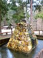
Every year in June, a three-day station festival is held on the premises of the Saxon Narrow Gauge Railway Museum, including a mat jumping for children on the Hammerbergschanze. In 2004, the Rittersgrüner Fuchsjagd, first held in 1978, was brought back to life by a sponsoring association. At the event, which takes place annually on the first Sunday in October, a rider marked with a foxtail is hunted. Participants include a partner riding club from Děpoltovice near Karlovy Vary . The supporting program includes falconry demonstrations, equestrian games, hunting horn blowing and riding for everyone. On the 1st of Advent, the Rittersgrüner open-air Christmas pyramid is pushed with the participation of the mayor, the pastor and the wind choir of the Evangelical Lutheran parish and the Knappschaft Rittersgrün.
societies


The Rittersgrüner association with the longest tradition is the Knappschaft Rittersgrün 1713 e. V. , which was founded in 1713 as a mining burial brotherhood and today, in addition to ceremonial burials, takes part in mining parades and maintains the Pöhla-Rittersgrün mining trail . The German gymnastics club Gut Heil was founded in 1880, followed by a military choir in 1890, the Frei Heil workers ' sports club in 1907 , a cycling club in 1919, a workers' choir in 1922 and a military rifle club in 1923. The community life was supplemented by the carving association Rittersgrün / Pöhla, the garden association Waldfrieden and an Erzgebirge branch association.
With the exception of the Rittersgrüner Knappschaft, all of the community's associations were dissolved after the Second World War. Winter sports, athletics, handball, fistball, artistic cycling and chess were practiced in the Rittersgrün sports community, founded in 1949. Together with the community, the sports community completed an outdoor pool that was started in 1938 and which is fed by the water of the Cunnersbach, a right tributary of the Pöhlwasser.
Today the Erzgebirgszweigverein, which was re-established in 1991, the Schützenverein 1883 and the Freie Sportverein 1907 with the departments handball, skiing, recreational soccer and fistball are active in Rittersgrün . The gym at the northern entrance to the village, inaugurated in 1926, was replaced by a new building at the school. The Hammerbergschanze, inaugurated in 1986, is located near the station area . In addition, there is the Rittersgrüner fox hunt , a tourist association, a senior citizens 'association, the chronicler regulars' table and the Rittersgrün volunteer fire brigade founded in 1879 with 25 active members.
Economy and Infrastructure
traffic
Rittersgrün is on the state road 271, which ends in Raschau in the federal road 101 , via which the motorway can be reached. A connecting road that joins the S 271 in the center of town leads to neighboring Breitenbrunn. There is a regular bus connection between Schwarzenberg and Tellerhäuser. In winter, ski buses run between Johanngeorgenstadt , Rittersgrün, Boží Dar and Oberwiesenthal .
Rittersgrün was from 1889 to 1971 on the upper section of the narrow-gauge railway Grünstädtel-Oberrittersgrün . The Unterrittersgrün stop and the Oberrittersgrün train station , which has housed the Saxon Narrow Gauge Railway Museum since 1977, were located in the municipality's territory . Today the nearest train station is on the Johanngeorgenstadt – Schwarzenberg railway line in Breitenbrunn.
Public facilities
Even before Rittersgrün was incorporated into Breitenbrunn, the administration of the municipality was outsourced to Breitenbrunn. In a citizen's office in the station building, individual departments of the municipal administration have regular consultation hours. The Rittersgrüner Tourist Office is located in the same building. The nearest police station is in Schwarzenberg. The volunteer fire brigade's depot is at the top of Rittersgrün.
The district has two day-care centers. The AWO Kinderland is located above the school in a building that was inaugurated as a Soyuz 31 kindergarten in 1979 . A private day-care center founded in 1997, which provides care according to Montessori education, is located in Globenstein.
education
In the oldest church book of the community, a knightly green schoolmaster is mentioned as early as the end of the 17th century . It is not known whether a school building already existed at that time. What is certain is that in 1832 a new schoolhouse was built near the church in place of a building demolished in 1830. In the mid-1830s, around 200 students were taught in two classes by a girl and a boy teacher. For capacity reasons, additional school buildings were opened in the upper part of the village and on the Hammerberg in 1851 and 1878 and the number of teachers increased. In 1905 a central school building for all Rittersgrüner students was inaugurated above the train station. Six teachers were responsible for 541 students in the year it opened. A further training school and a vocational school for women were also attached to the school. Since the 1960s, the Tellerhausen students had to attend classes in Rittersgrün, which made an extension necessary, which was completed in 1971. Since that time the school has been operated as a polytechnic high school . After the collapse of the GDR, it initially housed elementary and middle schools.
The middle school was closed in 2007 and relocated to Breitenbrunn. In return, the elementary school pupils from Breitenbrunn visit the school in Rittersgrün, which is run in one class with around 80 pupils (status: school year 2008/09).
Business and tourism
After the turn of 1989/90, most of the larger industrial companies were dissolved. Several earlier production sites, including the large Junghans Söhne factory complex between the church and the train station, are empty. The Modesta textile factory building was demolished. Globensteiner Holzwerkstätten GmbH and the trading company Henka Werkzeuge und Werkzeugmaschinen GmbH are located in Globenstein today . The tooling Weigel GmbH in Arnold Hammer provides tools primarily for her sprayings and stamping plants. Rittersgrün also has a car dealership, various craft businesses and small shops, a hotel with a restaurant, several guest houses and restaurants and a large number of private holiday accommodations. One of the goals of the Rittersgrün eV tourism association, which was founded in 1991, is the coordination of the tasks that are important for tourism between the community, tourism-oriented associations and the landlords. The association maintains a tourist office for Rittersgrün and Tellerhäuser in the main building of the Railway Museum.
Personalities
Daughters of the congregation
- Anna Franziska Schwarzbach (* 1949), architect and sculptor
- Roswietha Zobelt (* 1954), Olympic champion in rowing in 1976 and 1980
People connected to the place
- Nikolaus Klinger (around 1551–1610), founder of the later Schmertzinghammer
- Rudolph von Schmertzing (around 1580–1646), the previous son-in-law, major and owner of the Schmertzinghammer
- Heinrich Siegel (1612–1669), co-owner of Arnoldshammer
- Carl Gotthilf Nestler (1789–1864), co-owner of Arnolds- and Schmertzinghammer
- Eduard Wilhelm Breitfeld (1803–1873), the previous son-in-law, co-owner of Arnolds- and Schmertzinghammer
- Moritz Heinrich Rosenhauer (1803–1888), German Protestant pastor (1846–1856 in Rittersgrün) and politician
- Edwin Bauersachs (1893–1948), Ore Mountain dialect poet, went to school in Rittersgrün and worked there for a time
- Wolfgang Pintzka (1928–2006), theater director, lived in the village during World War II
- Karl-Heinz Schmidt (1938–2016), pastor and dialect author, grew up here
- Wilhelm Alban Barthel (1839–1912), known as "Dicker Fritz", musician, went to school in Rittersgrün and became famous in the city for his brass band, which went as far as Frankfurt / Main. His person is shown as a wall painting in the Frankfurt Römer.
literature
- Oskar Victor Geßner: Chronicle of the church village Rittersgrün. Self-published, Rittersgrün 1898
- Jonny Hielscher: Rittersgrün - From the beginning of settlement to the decline of the hammer mills. epubli GmbH, 2009, ISBN 978-3-86931-218-7
- Friedrich H. Hofmann : Rittersgrün & Breitenbrunn: From the history of both places and their postal system. Rockstroh, Aue 2006, ISBN 3-937190-07-4
- Gerhard Lang: Rittersgrün through the ages. Geiger-Verlag, Horb am Neckar 1993, ISBN 3-89264-835-2
- Siegfried Sieber : Around Aue, Schwarzenberg and Johanngeorgenstadt . Akademie-Verlag, Berlin 1972, pp. 158-165.
- Jonathan Sternkopf: 700 years of Rittersgrün in the Ore Mountains: 1251–1951. Municipal administration, Rittersgrün 1951. (Digitized: urn : nbn: de: bsz: 14-db-id51461370X4 )
- Knight green . In: August Schumann : Complete State, Post and Newspaper Lexicon of Saxony. 9th volume. Schumann, Zwickau 1822, pp. 210-212.
- Chief Knight Green . In: August Schumann : Complete State, Post and Newspaper Lexicon of Saxony. 7th volume. Schumann, Zwickau 1820, p. 648 f.
- Painings hammer . In: August Schumann : Complete State, Post and Newspaper Lexicon of Saxony. 10th volume. Schumann, Zwickau 1823, p. 409.
- Arnfried Viertel: Three centuries of Rittersgrün Church: history and stories of Rittersgrün . Rockstroh, Aue 2009, ISBN 978-3-937190-16-7
Web links
- Rittersgrüner magazine
- Rittersgrün in the Digital Historical Directory of Saxony
- Literature on Rittersgrün in the Saxon Bibliography
References and comments
- ↑ Small-scale community sheet for Breitenbrunn / Erzgeb. (PDF; 0.23 MB) State Statistical Office of the Free State of Saxony , September 2014, accessed on January 27, 2015 .
- ↑ German Weather Service: Average precipitation values for the period 1961–1990 (.zip file; 349 kB) ( Memento from September 23, 2015 in the Internet Archive ), accessed on May 10, 2009.
- ↑ http://www.smul.sachsen.de/umwelt/download/umweltstatus/6_Hochwasserentstehungsgebiete_in_Sachsen_-_LfULG.pdf (Link not available) Sylvia Walther (Saxon State Office for Environment, Agriculture and Geology): Flood development areas in Saxony - an instrument for flood protection in Saxony
- ↑ Michel Oelschlägel: August 14, 2003 Supercell (Frontgewitter.de) , accessed on May 10, 2009.
- ^ Frank Siegel: 750 years of Rittersgrün. Program and information. Aue 2001.
- ^ Johann Paul Oettel: Old and New History of the Royal. Pohln. and Churfürstl. Sächßl. freyen mountain town Eybenstock, in Meißnischen Ober-Erzgebürge. Schneeberg, Fulden, 1748, p. 293
- ↑ Schönburgisches Erbbuch de ao. 1559 ( Chemnitz State Archives , district tax revenue Annaberg, order 30346, no.143)
- ↑ a b Jonny Hielscher: “New findings on old hammer mills”, in: Official Gazette of the municipality of Breitenbrunn / Erzgebirge , No. 6/2009, p. 15f.
- ^ Gerhard Lang: Rittersgrün in the course of time. Geiger-Verlag, Horb am Neckar 1993, p. 6ff.
- ^ Oskar Victor Geßner: Chronicle of the church village Rittersgrün. Self-published, Rittersgrün 1898, p. 22
- ^ Oskar Victor Geßner: Chronicle of the church village Rittersgrün. Self-published, Rittersgrün 1898, p. 34
- ^ Friedrich H. Hofmann: Rittersgrün & Breitenbrunn: From the history of both places and their postal system. Rockstroh, Aue 2006, p. 21
- ^ Gerhard Lang: Rittersgrün in the course of time. Geiger-Verlag, Horb am Neckar 1993, p. 11
- ^ Oskar Victor Geßner: Chronicle of the church village Rittersgrün. Self-published, Rittersgrün 1898, p. 23ff.
- ^ Friedrich H. Hofmann: Rittersgrün & Breitenbrunn: From the history of both places and their postal system. Rockstroh, Aue 2006, p. 35
- ^ Gerhard Lang: Rittersgrün in the course of time. Geiger-Verlag, Horb am Neckar 1993, pp. 63 and 53
- ↑ 700 years of Rittersgrün in the Ore Mountains. Schwarzenberg: Gärtner, 1951, p. 15.
- ^ Gerhard Lang: Rittersgrün in the course of time. Geiger-Verlag, Horb am Neckar 1993, p. 135
- ^ Frank Siegel: 750 years of Rittersgrün. Program and information. Aue 2001, p. 14ff.
- ↑ StBA Area: changes from 01.01. until December 31, 2007
- ↑ Festschrift: 750 Years of Rittersgrün, Rittersgrün 2001, p. 16f.
- ↑ Person who determined the quantity and quality of charcoal required for use in smelters with a measure or coal basket .
- ↑ Rittersgrün in the Digital Historical Directory of Saxony
- ↑ According to written information from the registration office dated May 14, 2009, Rittersgrün had 1625 residents on May 8, 2009 (793 men and 832 women), two of whom were foreigners.
- ↑ Results of the local council elections in Rittersgrün on June 7, 2009 (statistical library.de)
- ^ Albin Weisbach: The iron meteorite from Rittersgrün in the Saxon Ore Mountains; Publishing house of the Royal Mining Academy, 1876
- ↑ Saxon State Association of Miners, Huts and Miners' Associations eV: Mining Trail Pöhla / Rittersgrün , accessed on May 10, 2009.
- ↑ Frank Nestler: “On horseback over the ridge: Riding trail from Rittersgrün to Karlovy Vary opened”, in: Freie Presse , Schwarzenberg edition of October 13, 2009, p. 11.
- ^ Oskar Victor Geßner: Chronicle of the church village Rittersgrün. Self-published, Rittersgrün 1898, p. 35.
- ^ Georg Dehio: Handbook of German Art Monuments Saxony : II. Administrative districts Leipzig and Chemnitz. Deutscher Kunstverlag, Munich 1998, p. 850
- ^ Förderverein Rittersgrüner Fuchsjagd eV: The Rittersgrüner Fuchsjagd . , accessed May 10, 2009.
- ↑ Skisprungschanzen.com ( Memento from February 21, 2009 in the Internet Archive ), accessed on May 10, 2009
- ^ Rittersgrün volunteer fire department , accessed on May 10, 2009
- ^ Gerhard Lang: Rittersgrün in the course of time. Geiger-Verlag, Horb am Neckar 1993, p. 123
- ^ Friedrich H. Hofmann: Rittersgrün & Breitenbrunn: From the history of both places and their postal system. Rockstroh, Aue 2006, p. 139
- ^ Elementary school Rittersgrün Breitenbrunn / Erzgeb. ( Memento of July 31, 2012 in the archive.today web archive ), accessed on May 10, 2009.
- ^ Frank Siegel: 750 years of Rittersgrün. Program and information. Aue 2001, p. 19.
Antonshöhe | Antonsthal | Breitenbrunn | Erlabrunn | Knight green | Stone heather | Dish houses
Historical: Arnoldshammer | Breitenhof | Carolathal | Honor lobe | Fallbach | Globe stone | Half mile | Rabenberg | Zweach