
Loft of honor


Ehrenzipfel is a group of houses in the municipality of Breitenbrunn / Erzgeb. in the Saxon Erzgebirgskreis .
Geographical location
Ehrenzipfel is right on the border with the Czech Republic in the Pöhlwasser valley . State road 271 leads through the village from Raschau to Oberwiesenthal .
history
In the 17th century there were three "old colliery houses" in Ehrenzipfel, the owners of which were given a piece of land ("space") on December 14, 1686. The name "old colliery houses" testifies that the small settlement owes its origin to old mining activities . The name researcher Volkmar Hellfritzsch interprets the place name as a remote corner ("errn zibbel"). The group of houses initially belonged to Oberrittersgrün, from 1856 to the municipality of Rittersgrün and after its incorporation in 2007 to the municipality of Breitenbrunn.
In 1833 the place became known nationwide when the forest worker Karl August Reissmann found a meteorite in the forest . The rock, which weighs 85 kg and was later referred to as the Rittersgrüner Meteorite , is now in the mineralogical collection of the Bergakademie Freiberg and a copy in the Rittersgrün narrow-gauge railway museum.
Around 1900 Ehrenzipfel took off as a summer resort. The popular Gasthaus zur Patscherei , which was right on the border on the Bohemian side, contributed to this. It belonged to the Goldenhöher district of Bohemian Mill and was demolished in 1949/50. In addition to agriculture, other branches of business were two hydropower-operated wood grinding shops (Max and Albert Reissmann, Ottomar Reissmann) and a sawmill (Seltmann), which existed until the early 1960s.
From Ehrenzipfel, the German-Czech state border runs in a south-easterly direction over the Kaffenberg to Tellerhäuser and on to Oberwiesenthal . The extensive forest area around the place can be used for long hikes and ski tours (cross-border trails) in summer and winter.
Wettinplatz
About 350 meters after leaving the village in the direction of Tellerhäuser you will find Wettinplatz on the right side of the street, which was thoroughly renovated in 1991/92 by the Erzgebirgszweigverein Rittersgrün and inaugurated in 1992. The square is dominated by the Wettin Fountain, which was built in 1889 to commemorate the 800th anniversary of the Saxon ruling family Wettin . A few meters away is the mouth hole of the foxhole treasure trove, which was probably posted in the 15th or 16th century and is now open to visitors. The Wettinplatz has been connected to the Anton-Günther-Weg since 1995 . Since 1996 a memorial stone has been commemorating the Erzgebirge singer and folk poet .
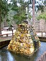
Betting fountain

Anton Günther memorial stone
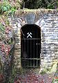
Mouth hole of the fox tunnel


Web links
- Honor peak in the digital historical place directory of Saxony
Individual evidence
- ↑ Volkmar Hellfritzsch: Ehren- in the place names Ehrenfriedersdorf and Ehrenzipfel , in: Erzgebirgische Heimatblätter 41 (2019), Heft 4, pp. 10-12. ISSN 0232-6078
Antonshöhe | Antonsthal | Breitenbrunn | Erlabrunn | Knight green | Steinheidel | Dish houses
Historical: Arnoldshammer | Breitenhof | Carolathal | Honor lobe | Fallbach | Globe stone | Half mile | Rabenberg | Zweach
Coordinates: 50 ° 28 ' N , 12 ° 50' E