
Schwarzwasser (Zwickauer Mulde)
| Black water | ||
 The Schwarzwasser in Schwarzenberg |
||
| Data | ||
| Water code | DE : 5412, CZ : 1-15-04-006 | |
| location | Saxony , Czech Republic | |
| River system | Elbe | |
| Drain over | Zwickauer Mulde → Mulde → Elbe → North Sea | |
| source | at Hinteren Fichtelberg 50 ° 25 ′ 8 ″ N , 12 ° 56 ′ 16 ″ E |
|
| Source height | approx. 1117 m above sea level NHN | |
| muzzle | in Aue in the Zwickauer Mulde Coordinates: 50 ° 35 ′ 19 ″ N , 12 ° 42 ′ 7 ″ E 50 ° 35 ′ 19 ″ N , 12 ° 42 ′ 7 ″ E |
|
| Mouth height | 342.3 m above sea level NHN | |
| Height difference | approx. 774.7 m
|
|
| Discharge at the gauge Aue 1 A Eo : 363 km² Location: 1 km above the mouth |
NNQ (09/20/1947) MNQ 1928–2014 MQ 1928–2014 Mq 1928–2014 MHQ 1928–2014 HHQ (08/13/2002) |
160 l / s 1.32 m³ / s 6.31 m³ / s 17.4 l / (s km²) 67.5 m³ / s 315 m³ / s |
| Left tributaries | Schieferbächel , Breitenbach , Steinbach , Fällbach | |
| Right tributaries | Große Mittweida , Großer Ortsbach , Podleský potok | |
| Reservoirs flowed through | Myslivny reservoir | |
The Black Water ( Černá in Czech ) is a right tributary of the Zwickauer Mulde in Saxony and the Czech Republic .
course
It rises on the Hinterer Fichtelberg (1206 m) in the Ore Mountains , initially flows in a westerly direction and bears the name Seifenbächel as far as the Czech border not far from Gottesgab ( Boží Dar ) .
The Plattner artificial ditch (Blatensky přikop) branches off at the now defunct Neumühle , which once supplied black water to the mines in the Platten mountain area (Horní Blatná) on the Plattenberg as impact water .
In the Czech Republic were at the river early yet for the most part after the Second World War by the expulsion of the German population desolate fallen places forester houses ( Myslivny ) , Zwittermühl ( Haje ) , Young Stallion ( Luhy ) and Brettmühl (Pila) .
At Wittigsthal , a district of Johanngeorgenstadt , the black water flows back to Germany and takes in the Breitenbach (Blatenský potok) coming from Breitenbach ( Potůčky ) .
On the further course of the black water, which now flows in a northerly direction, numerous hammer mills have been built since the 16th century because of the iron ore deposits that occur there. Zain- , Zeug- or bar Hammers were in Wittigsthal, Erlabrunn and Breitenhof operated.
The Steinbach flows into Erlabrunn, where a lively tin soap factory had ruled since the 16th century . Between Breitenbrunn / Erzgeb. and Antonsthal branches off a ditch that supplies the silver washing mill in Antonsthal with additional water when there is a lack of water. This trench is a special water-management construction work, as it winds along the slope for several kilometers and finally flows into the Halsbach coming from the northwest , shortly before it reaches the Schwarzwasser. The König-Anton-Hütte ironworks was built in Antonsthal in 1831 . There was also a well-known ironworks and rolling mill in Erla , the Erlhammer .
The black water flows through the town of Schwarzenberg , where the Große Mittweida flows into.
Just before the river Aue with the Zwickau Dell combines, was on its right bank in the village of Lower Pfannenstiel the famous Blue Color Works Low Pfannenstiel .


(view to Ryžovna (far left) and the Plattenberg (far right) )
history
August Schumann wrote in the Complete State, Post and Newspaper Lexicon of Saxony , about the Schwarzwasser:
“This river, initially Bohemian […], then belongs entirely to Saxony, and almost exclusively to the Schwarzenberg district office. Next under Aue it unites with the not stronger, even somewhat insignificant in terms of the river area, Zwickau Mulde, which, however, continues to maintain its name. The black water got its name in contrast to the Pöhl (originally Biela, di Weißwasser), which actually has a lighter water [...]. The Pöhl dilutes this brown color very noticeably near Sachsenfeld. [...]
Because of the many smelting works, the fishery in the same is relatively small, although formerly, especially at Sachsenfeld, the most excellent trout weighing up to 9 pounds, and considerable salmon were caught at Aue; On the other hand, without thinking of a multitude of grinding mills, board mills, and also a few oil mills, the use of water in the operation of works of art is great. Because it is due to the artifacts of Johannes am Roten Berge, the Irrgangs, several ironworks near Johanngeorgenstadt etc., furthermore 3 small Bohemian blue paintworks, and the excellent Saxon one at Pfannenstiehl, the Schwarzenberg Drathhammer, the hammer works Wittichsthal, Breitenhof and Erlahammer, three hammers at Schwarzenberg and Untersachenfeld, several works near Platten etc. However, 5 large hammer mills, 4 small hammers, an important wire mill, 3 Vitriol mills etc. are set in motion by the side waters of the river.
The river is still important because of the wooden rafts, as 2600 fathoms of 8/4 logs are rafted annually, certain and quite a lot indefinitely, but also a lot of sticks. Each of the 3 Saxon hammer mills receives 350 fathoms, the Pfannenstiehler works for 1000 fathoms of logs; the rest of them are preserved in Schwarzenberg, Sachsenfeld, Beyerfeld, Bernsbach, etc. These rafts and the rafts connected to them are already underway on the Mittweide in 1571; The latter was particularly strong around 1669, when the forests on the Erbisbach began to be cut, and where the landesh. Forests of the Erbisleite, the Kaffberg, Henneberg, Hell, etc. until God's gift was estimated at 100,000 trays. [...] The black water rafts have their expedition in a private house in Schwarzenberg, and a special raft master. The wood comes almost exclusively from the domain forests, is driven by the loggers on hand sledges to the rivers in winter, and thrown into the swollen water, which cannot be artificially reinforced by raft ponds, in spring. [...]. "
Individual evidence
- ^ German Hydrological Yearbook Elbe Region, Part I 2014. (PDF) State Office for Flood Protection and Water Management Saxony-Anhalt, p. 136 , accessed on November 3, 2018 (from: lhw.sachsen-anhalt.de).
- ↑ See Schwarzwasser . In: August Schumann : Complete State, Post and Newspaper Lexicon of Saxony. 10th volume. Schumann, Zwickau 1823, pp. 794-800.
literature
- Hydrological manual. (PDF; 115 kB) Part 2 - Area Codes. Free State of Saxony - State Office for Environment and Geology, p. 12 , accessed on December 25, 2017 .
- Jörg Brückner u. a .: The Schwarzwassertal from Fichtelberg to Zwickauer Mulde in historical views , Horb am Neckar 1993.
gallery
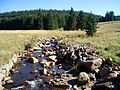
The black water at Luhy

The black water above Potůčky
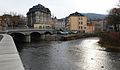
Aue: mouth of the black water (left) into the hollow


