Stará role
| Stará role | ||||
|---|---|---|---|---|
|
||||
| Basic data | ||||
| State : |
|
|||
| Region : | Karlovarský kraj | |||
| District : | Karlovy Vary | |||
| Municipality : | Carlsbad | |||
| Area : | 529.0993 ha | |||
| Geographic location : | 50 ° 15 ′ N , 12 ° 50 ′ E | |||
| Height: | 390 m nm | |||
| Residents : | 8,015 (March 1, 2007) | |||
| traffic | ||||
| Railway connection: | Karlsbad – Johanngeorgenstadt | |||
| Next international airport : | Karlovy Vary Airport | |||
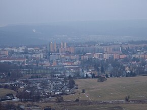
Stará Role (German: Altrohlau ) is a district of the city of Karlsbad in the Okres Karlovy Vary in the Czech Republic .
Geographical location
Stará Role is located in western Bohemia , about five kilometers northwest of the city center of Karlovy Vary. The average altitude is 392 m above sea level. m. The Rolava ( German Rohlau ), a tributary of the Eger ( Czech Ohře ) flows through the village .
history
Altrohlau was first mentioned in a document in 1422. From the second half of the 16th century there was a fortress on this site, which was completely destroyed in the Thirty Years War .
In 1847 there were 67 houses with 484 inhabitants. Until the abolition of patrimonial rule in the Austrian Empire in 1848/49, Altrohlau belonged to the Tüppelsgrün rule . In 1849 the place was incorporated into the judicial district of Karlsbad . Altrohlau was originally parish to Zettlitz and was raised to its own parish at the beginning of the 20th century. Part of Putschirn was parish .
After the First World War , Alt Rohlau was added to the newly created Czechoslovakia in 1919 . In 1926 Altrohlau received city rights. Due to the Munich Agreement , the place came to the German Reich in 1938 and until 1945 belonged to the district of Karlsbad , administrative district of Eger , in the Reichsgau Sudetenland .
After the end of the Second World War , the Sudeten German population was largely expropriated and expelled , citing the Beneš decrees issued in 1945 . In 1968 Viernheim in Hessen took over the sponsorship of the displaced citizens from Altrohlau living in Germany. In 1976 the city was incorporated into Karlsbad .
economy
In 1814 a factory was built in Altrohlau that initially produced earthenware . In the two decades that followed, production continued to expand, with porcelain production starting in 1836 . The factory is one of the oldest porcelain manufacturers in the area. In 1870 800 employees worked in the company, in 1909 it was taken over by the German company CM Hutschenreuter . After the end of the war in 1945 it was nationalized, and today the company manufactures utility porcelain under the name Starorolský porcelán Moritz Zdekauer .
Demographics
Until 1945 Alt Rohlau was predominantly settled by German Bohemia , which were expelled.
| year | Residents | Remarks |
|---|---|---|
| 1785 | k. A. | 34 houses |
| 1843 | 441 | |
| 1847 | 484 | in 67 houses |
| 1857 | 879 | |
| 1869 | 1,331 | |
| 1890 | 3,346 | |
| 1900 | 5,358 | |
| 1910 | 7,058 | |
| 1921 | 6683 | including 6,488 Germans |
| 1930 | 7,660 | |
| 1939 | 7.091 |
| year | 1947 | 1961 | 1970 | 1991 | 2001 |
| Residents | 3,307 | 4,896 | 7,018 | 8,639 | 8,139 |
traffic
Stará Role lies on the railway line No. 142 Karlsbad – Johanngeorgenstadt .
Attractions
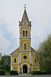
The only church in Stará Role is the Church of the Ascension of Christ. It was built on the site of a smaller chapel, which had existed since 1823, according to plans by Hermann Fiedler and was consecrated on October 10, 1909 by Archbishop Leo Skrbenský of Hříště of Prague .
Individual evidence
- ↑ Katastrální území Stará Role: podrobné informace (cadastral area of Stara Rolle: details) accessed on www.uir.cz on March 14, 2014
- ↑ Johann Gottfried Sommer: The Kingdom of Bohemia: bd. Elbogner Kreis. 1847 . JG Calve, 1847 ( google.de [accessed March 1, 2020]).
- ^ Genealogy: Bohemia, Sudetenland, Parish Books, Alt-Rohlau, Karlsbad. Retrieved March 1, 2020 .
- ^ Rudolf Hemmerle : Sudetenland. Signpost through an unforgettable land (= signpost through an unforgettable land. Geographic lexica. 4). Kraft, Würzburg 1993, ISBN 3-8083-1193-2 , p. 36.
- ^ Alfred Schickel : The expulsion of the Germans. History, background, reviews. MUT, Asendorf 1985, ISBN 3-89182-014-3 .
- ↑ Jaroslaus Schaller : Topography of the Kingdom of Bohemia . Volume 2: Ellbogner Kreis , Prague 1785, p. 74, item 35) .
- ↑ Johann Gottfried Sommer : The Kingdom of Bohemia . Volume 15: Elbogner Kreis , Prague 1847, p. 106, item 3).
- ↑ a b weekly newspaper for Karlsbad and the surrounding area . Volume 10, No. 24 of June 11, 1870, p. 316, left column .
- ^ Sudetenland Genealogy Network
- ^ A b Michael Rademacher: German administrative history from the unification of the empire in 1871 to the reunification in 1990. City and district of Karlsbad. (Online material for the dissertation, Osnabrück 2006).


