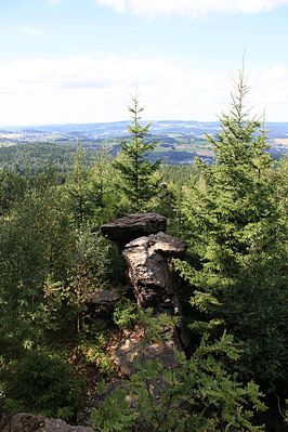
Ox head near Rittersgrün
| Ox head near Rittersgrün | ||
|---|---|---|
|
View from the Ochsenkopf towards the Spiegelwald |
||
| height | 835.7 m above sea level NHN | |
| location | Erzgebirgskreis , Saxony ( Germany ) | |
| Mountains | Ore Mountains | |
| Coordinates | 50 ° 28 '52 " N , 12 ° 48' 52" E | |
|
|
||
| rock | Mica slate | |
Ochsenkopf is the name of a 835.7 m above sea level. NHN high mountain near Rittersgrün in the Saxon Erzgebirgskreis .
The mountain east of the Breitenbrunn district can be reached via the road called Hammerberg. The last stretch to the summit is the shortest route from the Waldburg restaurant, which was built in 1903/04 . There are several rocks made of light-colored mica schist on its top . From the highest point, where a rest area has been created, there is no view due to the dense forest. However, various, slightly lower-lying viewpoints allow good panoramic views over the Pöhlwassertal . The mountain heights between Auersberg and Morgenleithe can be seen on the horizon .
The Rittersgrün waterworks, built in 1940, is located on the edge of the forest below the Ochsenkopfes. This is where a nearly 15-kilometer hiking trail begins through what Christian Lehmann calls "high forests" via Altpöhlaer Straße to Fichtelberg .
literature
- About Aue, Schwarzenberg and Johanngeorgenstadt (= values of our homeland . Volume 20). 1st edition. Akademie Verlag, Berlin 1972, p. 164.
Individual evidence
- ↑ a b Saxony Atlas of the Free State of Saxony ( notes )

