
Britzingen

| |
Location of Britzingen in Baden-Württemberg |
Britzingen ( Alemannic : Britzige ) is a village with 1003 inhabitants (as of March 2019) in the district of Breisgau-Hochschwarzwald in Baden-Württemberg . The formerly independent municipality of Britzingen has been part of the city of Müllheim since January 1, 1974 . The village of Dattingen and the hamlets of Güttigheim and Muggardt belonged to the former municipality of Britzingen .
geography

Britzingen is located in the Breisgau and Markgräflerland , about 25 kilometers south-southwest of Freiburg . Located in the hilly foothills of the Black Forest , the terrain immediately east of the village of Britzingen rises by 200 meters to the foothills of the Black Forest. The slopes inclined to the west and south are largely covered with grapevines. The area around Britzingen is drained by the Ehebach , which rises in the Black Forest at 600 m above sea level and flows into the Sulzbach via Britzingen, Dattingen and Buggingen in the Rhine plain , which seeps into the Rhine floodplains near Grißheim . The Britzingen district covers about 10 km². Neuenfels Castle , a spur castle ruin, is enthroned at 595.1 meters above sea level in the southeast of the district .
history
Archaeological finds in the win of the Himmelstiege vineyard testify to an early settlement of the area around Britzingen from the Hallstatt period . Excavation finds near the Johanneskirche point to a Celtic village with Roman overbuilding from around 150 AD. In 773 the place name Britzingen first appeared in a document.
The lords of Britzingen in the middle of the 12th century were the Zähringer , later the Freiburg counts , the Johanniter from Heitersheim and the margraves of the house of Hachberg-Sausenberg .
In its history, Britzingen has often been exposed to wars and devastation. After each destruction, the returned residents rebuilt the village.
The hardship in the southern Baden villages at the end of the 19th century led to the establishment of the first farming cooperatives based on the ideal of Friedrich Wilhelm Raiffeisen . After the Second World War, in 1950, the Britzingen wine cooperative was founded on the basis of these ideals.
Britzingen has had the title of state-approved resort since 1981 . In 1988 Britzingen won first place in the state competition Our village should become more beautiful .
coat of arms


Blazon : "In a half-split and divided shield at the top in front in gold a red sloping bar, behind in red a golden post covered with three black rafters, below in blue a golden karst ."


Culture and sights
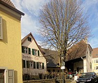
The wine-growing village of Britzingen is located in the center of the Markgräfler wine-growing region . A section of the old Baden Wine Route leads through the village with well-tended courtyards, wells and inns.
- Evangelical St. John's Church from the 13th or 14th century, probably built on the foundations of a " villa rustica "
- several wells
- historical courtyards and inns
- Wine cooperative
- Neuenfels-Halle , ballroom and event hall

Johanneskirche

Interior view of the Johanneskirche

primary school
Neuenfels Hall

one of the Britzinger fountains


Economy and Infrastructure
Viticulture and tourism are the most important industries in Britzingen today. The Rieger company is a plastics processing company in Britzingen that equips chemical companies with pipelines, fittings and containers that work with corrosive substances. In addition, several craft and service companies are based in Britzingen, including the supraregional carpenter's workshop Marx . Many residents are commuters to the surrounding cities and communities. Britzingen has no supermarkets and no petrol stations, but there are several restaurants and a village shop with a café set up by the village community in the former Englerhof estate . The listed Englerhof was built in 1795 as a typical Markgräfler homestead with a courtyard entrance and barn, attached to the residential building that has existed since 1785. After the city of Müllheim acquired the property, it was converted into a village community center with a café and village shop and opened in September 2011.

Wine cooperative

Behringer winery

Plastics processing company Rieger

Carpenter Marx


- Gastronomy in Britzingen

Gasthof "Hirschen"
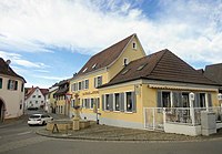
Gasthof "Zur Krone"

Gasthaus "Ehebachhof"
Village shop and café in the former Englerhof


Britzingen is connected to the surrounding towns by roads: a country road leads to the northwest to Buggingen , to the northeast via Sulzburg - Laufen to Staufen im Breisgau , to the southeast via the Schwärze pass to Badenweiler and in the southwest via Zunzingen to Müllheim . Local public transport is guaranteed by SWEG buses . The nearest train stations are in Müllheim and Buggingen on the Mannheim – Basel railway line . Over the six kilometers away Neuenburg there is a connection to the motorway A 5 ..
supporting documents
- ↑ Numbers on muellheim.de. Retrieved on February 25, 2020 (German).
- ↑ History abstract on alemannische-seiten.de
Web links
Coordinates: 47 ° 49 ′ 40.4 " N , 7 ° 40 ′ 21.9" E