
Forest fishing hole
|
Forest fishing hole
City of Sinsheim
|
|
|---|---|
 |
|
| Height : | 185 m |
| Residents : | 1634 (December 31, 2017) |
| Incorporation : | July 1, 1972 |
| Postal code : | 74889 |
| Area code : | 07265 |
 Location of Waldangelloch in Sinsheim
|
|
Waldangelloch is a village in the Rhein-Neckar district in Baden-Württemberg , which has belonged to Sinsheim since 1972 .
geography
Waldangelloch lies in the hilly landscape of the Kraichgau in northern Baden-Württemberg at about 197 m above sea level. NN in the Angelbachtal. The valley basin of the uppermost, northwest moving Waldangelbach runs in the local area from the east to the Winkelbach . The village lies in the transition zone from the reed sandstone ( Stuttgart Formation ) to the Gipskeuper ( Grabfeld Formation ), which are surrounded by indented hills around the town from further tributaries - Gänswiesengraben from the northeast, still in the village area, Eberbach from the south, partly beyond the boundary partially covered with loess sediment .
Waldangelloch is surrounded by a one to two kilometer wide clearing strip, beyond which, in a large arc from north to south-west, the Great Forest on the rise to the Keuperberge lies around the corridor, only to the north-west does the (forest) Angelbachtal open in the direction of Michelfeld . The lowest point of the district is a little over 170 m above sea level. NN at the outlet of the Waldangelbach, the Dammberg in the west and southwest of the village, on whose flat lower slope most of the newer parts of the building stand, rises to 261.3 m above sea level. NN , the Kornberg in its east up to 248.7 m above sea level. NN , the mouth of the Winkelbach up to 256.7 m above sea level. NN . Within the Waldangelloch clearing island, in addition to these hills, lies the Buchenauerhof in the east, surrounded by the grounds of the Sinsheim Golf Club, which , however, already belongs to the district of the Sinsheim village of Weiler .
history


The place developed below the Waldangelloch Castle . The castle district, that is, the part of the settlement that was on the same side of the Angelbach as the castle, was completely under the rule of the respective castle lords. The rest of the village on the other side of the Angelbach was subject to a condominium from the respective castle rulers and the Odenheim monastery . The two districts were connected by an old stone bridge that existed until the 20th century. The place was first mentioned in 1225 in a document from King Henry VII, who confirmed the ownership of the monastery in Angelacha . The lords of the castle from the 13th to the early 17th century were the Knights of Angelach , who had the castle and other property in the place as a fiefdom of the Counts of Eberstein . Another place called Angelloch, about 20 km away near Leimen , also goes back to the von Angelach . To differentiate the places, the place names were later extended by a prefix and became Waldangelloch or Gauangelloch .
After the Lords of Angelach died out in 1608 or 1613, Count Philipp III. von Eberstein regained ownership of Waldangelloch. After the death of the last descendants of Eberstein Casimir (1639-1660), the Ebersteinsche share in 1679 reached about his widow and his daughter's marriage Sofie Esther Elbertine Eberstein (1661-1728) with Friedrich August von Württemberg-Neustadt to the house Württemberg . Schools, church, hunting and fishing were from then on with Württemberg, the land rulership was divided between a condominium from Württemberg and the knight monastery of Odenheim, which now resides in Bruchsal. As a result of the Reichsdeputationshauptschluss 1803, the ownership of the monastery came to the Grand Duchy of Baden , with the exchange and epuration contract in 1806, the half of Württemberg followed. Waldangelloch came to the Baden office of Odenheim .
The place had around 800 inhabitants around 1800 and was characterized by agriculture and craft for a long time. In terms of handicrafts, joiners , sieve makers and rake makers should be mentioned in particular . After the transition to Baden, numerous foreigners moved here. As a result of this and a high birth rate, the population increased by over 200 people in the period from 1802 to 1823. In 1827 there were 1074 inhabitants. The municipal administration promoted emigration and was able to alleviate the plight of the population and stabilize the municipal finances until the 1860s. From the 1880s onwards there were several, at times up to ten, cigar factories in Waldangelloch, in which over 200 men and women were employed in the years before the First World War. In 1901 Waldangelloch was connected to the railway network by the Wiesloch – Meckesheim / Waldangelloch railway. Because of the high cost sharing, other local projects such as the construction of a new school house or a water pipe had to be postponed.
During the First World War and the subsequent period of inflation, the place experienced a temporary decline in cigar factories, combined with emigration due to unemployment. A stick factory offered new jobs for a few years. In 1939 there were 874 inhabitants, at the end of 1945 there were 900.
After the Second World War, some 300 displaced native settled Hungary German from Pomáz on. After the currency reform in 1948 , seven out of ten cigar factories in town closed by 1960. The settlement of a fine hosiery factory and a precision engineering factory in two former cigar factories offered some women new jobs, while male workers mostly only found work abroad. From 1959 onwards, several large building areas were redesignated on an area of around 10 hectares, in which 162 new residential buildings were built by 1975. The structural change in the post-war period also led to the abandonment of most of the 193 farms that had existed from 1950. From 1964 to 1969 the through traffic was expanded. The fishing stream in the locality was also condemned . Waldangelloch was incorporated into Sinsheim on July 1, 1972 and today has around 1,800 inhabitants.
coat of arms
The coat of arms of Waldangelloch shows a silver fish hook on a blue background and is derived from the coat of arms of the Lords of Angelach , who died out in the 17th century and which the community adopted early on. The coat of arms of those of Angelloch shows a fish hook open to the left and became the local coat of arms of Gauangelloch ; The hook on the coat of arms of Waldangelloch is open to the right to distinguish it.
Attractions
Buildings

- The castle ruins of Waldangelloch Castle, which was built in the high Middle Ages, include some walls, two towers and remains of the foundations of the complex that once stood above the village in the spur.
- The Evangelical Church was built in 1861 by architect Friedrich Theodor Fischer (1803-1867) below the cemetery. A much smaller previous building, probably from 1518, had been in the cemetery. The nearby old parsonage from 1848 came after a new building in Gewann Finkenherd in 1972 into the possession of the city of Sinsheim, which converted it into the administration building of the social station.
- The Catholic Church of St. Mary, Help of Christians was built in 1959 for the Catholic community, which had grown due to the influx of displaced people.
- The town hall was built as a schoolhouse in 1839 and after completion of the neighboring schoolhouse in 1907/08 it was converted into an administration building.
- The Gasthaus zum Bahnhof was built in 1896.
- There are several historical buildings in the village, including the former baroque knight's inn on the road to Weiler and several sandstone barns.

town hall

school

Fountain at the town hall
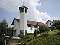
Catholic Church of St. Mary

Historic barn

Pomazer Heimatstube


Museums
The Pomazer Heimatstube of the Hungarian Germans from Pomáz is on the upper floor of the mayor's office, which is open on the first Sunday of the month in the summer months and shows numerous exhibits of this ethnic group. The Pomazer Platz in front of the mayor's office is also named after this country team.
Bicycle traffic
The Kraichgau-Stromberg Castle Tour runs through Waldangelloch , an approximately 52-kilometer regional cycle route that connects the village with the surrounding villages of Weiler and Michelfeld.
Personalities
sons and daughters of the town
- Karl Friedrich Hipp (1763–1838), mathematician and educator
- Gotthold Sabel (1852–1909), educator, church councilor and heraldist
- Rudolf Horn (1903–1984), classical archaeologist
- August Vischer (1821–1898), history painter
- Stefan Wollenstein (1977), founder of Second Bandshirt and bassist of the punk band Scherben
Individual evidence
- ↑ Keller 1975, pp. 19-23.
- ↑ Keller 1975, pp. 34-36.
- ↑ Communications from the Württ. And Bad. State Statistical Office No. 2: Results of the population census on December 31, 1945 in North Baden
- ^ Federal Statistical Office (ed.): Historical municipality directory for the Federal Republic of Germany. Name, border and key number changes in municipalities, counties and administrative districts from May 27, 1970 to December 31, 1982 . W. Kohlhammer, Stuttgart / Mainz 1983, ISBN 3-17-003263-1 , p. 479 .
- ↑ Kraichgau-Stromberg: Castle Tour | Vacation country Baden-Wuerttemberg. Retrieved June 21, 2020 .
literature
- Karl Keller: From Waldangelloch's Past , Waldangelloch 1975
- Käthe Zimmermann-Ebert: Large district town Sinsheim - around the Steinsberg. Sinsheim 1990
Web links

Adersbach | Dühren | Ehrstädt | Eschelbach | Hasselbach | Hilsbach | Hoffenheim | Core city | Rows | Rohrbach | Steinsfurt | Forest fishing hole | hamlet