
Rohrbach (Sinsheim)
|
Rohrbach
City of Sinsheim
|
|
|---|---|
.svg) |
|
| Area : | 7.97 km² |
| Residents : | 2210 (December 31, 2017) |
| Population density : | 277 inhabitants / km² |
| Incorporation : | December 31, 1971 |
| Postal code : | 74889 |
| Area code : | 07261 |
 Location of Rohrbach in Sinsheim
|
|
Rohrbach is a village in the south of the Rhein-Neckar district in Baden-Württemberg , which has belonged to Sinsheim since 1971 .
history
Rohrbach was first mentioned in a document in 1099. In 1427 the place came to the Lords of Venningen as a fief of the diocese of Worms . In the 17th century, the place shared the fate of the surrounding places and was hit by devastation several times, including during the Thirty Years War and in the vicinity of the Battle of Sinsheim in 1674.
At the time of Elector Karl Theodor (1724-1799) was Carl Philipp von Venningen District President in Mannheim and sat for expanding from Frankfurt to Heilbronn leading road from Sinsheim Rohrbach to Steinsfurt one - not originally planned, the route guidance directly from Sinsheim to Steinsfurt. The traffic connection initially led to a revitalization of the place, in which six inns were soon built . However, the conveniently located place also became frequent quarters for troops in the subsequent Napoleonic Wars .
Rohrbach came to Baden in 1806 . The prevailing poverty and lack of employment opportunities increasingly led to emigration in the middle of the 19th century . Between 1834 and 1865, 50 people emigrated to North America. Rohrbach remained predominantly agricultural until well into the 20th century . The first factory jobs were created in an enamel factory and in the Schmollschen Mühle, where iron and tin goods were manufactured. In 1939 there were 726 inhabitants, at the end of 1945 there were 813.
After the Second World War , Rohrbach was assigned numerous expellees from the former German eastern regions , the Sudetenland and Hungary , whose integration posed major problems for the community. In the post-war years, extensive new building areas emerged and the place developed from a rural village to a place of residence for commuters from the surrounding areas. Of the 129 full-time farms counted in 1939, only a few remained at the end of the 20th century.
On December 30, 1971, Rohrbach was incorporated into the city of Sinsheim. The former municipality had an area of 7.84 km².
coat of arms
The blazon reads: three black cattails with green stems and two green leaves each growing out of a lowered blue wavy bar .
Attractions

- The old town hall was built by the Lords of Venningen as a rent office and once also housed the Catholic school on the upper floor. After 1845 it was the town hall and since the municipal reform the local administration is located here.
- The Evangelical Church in Rohrbach was built in 1823 on the site of a previous building. The Protestant parsonage , which was completed in 1859 and which was a condition for the re-establishment of a pastorate, was described as "one of the most magnificent parsonages in the country". The Catholic St. Laurentius Chapel was consecrated in 1966 in the new building area.
- The old school building next to the Protestant church was completed in 1839.
- The former synagogue tells of the town's former Jewish community . The building once housed the Israelite school , the classroom of which later served as a kindergarten and as a classroom after the Second World War.
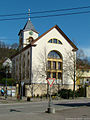
Protestant church

Old school

Former synagogue


Bicycle traffic
The Kraichgau-Stromberg Castle Tour runs through Rohrbach , an approximately 52-kilometer regional cycle route that connects the village with the towns of Neckarbischofsheim and Steinsfurt.
Individual evidence
- ↑ Communications from the Württ. And Bad. State Statistical Office No. 2: Results of the population census on December 31, 1945 in North Baden
- ^ Federal Statistical Office (ed.): Historical municipality directory for the Federal Republic of Germany. Name, border and key number changes in municipalities, counties and administrative districts from May 27, 1970 to December 31, 1982 . W. Kohlhammer, Stuttgart / Mainz 1983, ISBN 3-17-003263-1 , p. 479 .
- ^ Federal Statistical Office (ed.): Official municipality directory for the Federal Republic of Germany. Final results after the census of September 13, 1950 (= Statistics of the Federal Republic of Germany . Volume 33 ). W. Kohlhammer, Stuttgart / Cologne 1952, p. 122 ( digital version [PDF; 27.1 MB ]).
- ↑ Kraichgau-Stromberg: Castle Tour | Vacation country Baden-Wuerttemberg. Retrieved June 21, 2020 .
literature
- Käthe Zimmermann-Ebert: Large district town Sinsheim - around the Steinsberg. Sinsheim 1990
Web links

Adersbach | Dühren | Ehrstädt | Eschelbach | Hasselbach | Hilsbach | Hoffenheim | Core city | Rows | Rohrbach | Steinsfurt | Forest fishing hole | hamlet