
Steinsfurt
|
Steinsfurt
City of Sinsheim
|
|
|---|---|
 |
|
| Height : | 164 m |
| Area : | 12.08 km² |
| Residents : | 3269 (December 31, 2017) |
| Population density : | 271 inhabitants / km² |
| Incorporation : | 1st January 1973 |
| Postal code : | 74889 |
| Area code : | 07261 |
 Location of Steinsfurt in Sinsheim
|
|
Steinsfurt is a village in the south of the Rhein-Neckar district in Baden-Württemberg , which has belonged to Sinsheim since January 1, 1973 .
Geographical location
Steinsfurt is located in the hilly Kraichgau on both banks of the Elsenz at the beginning of the Sinsheim valley widening of the small river. It flows south of the village from the east of the Insenbach , in the center of the village from the northeast the Goldbach , both right tributaries. The district extends from east-northeast to west-southwest across the river valley for about 6 km, perpendicular to it in the direction of the river it measures just a little more than 2.5 km at its widest point. The Ilvesbach is a long border brook of the district in the west. The highest point of the district lies between Insenbach and Goldbachtal on the road to Ehrstädt at around 284 m above sea level. NN , the lowest in the wide Elsenz-Aue at about 157 m above sea level. NN .
The district boundary borders in the north on that of the next valley village Rohrbach , which itself is only about one and a half kilometers away, the east mostly on the Ehrstädter , whose village center is more than 5 km as the crow flies, and for a short distance also Adersbach or the of the even more distant Grombach . Along the southern border stretches the demarcation of rows , the next upper valley village two and a half kilometers away. Finally, in the west are the districts of Weiler and finally in the northwest of Sinsheim itself. With the exception of Grombach, which belongs to Bad Rappenau in the neighboring district of Heilbronn , all other neighboring districts are Sinsheim.
From a natural perspective, Steinsfurt is located in the Lein-Elsenz-Hügelland , the slightly larger and more profiled part in the east belongs to the Neckarbischofsheimer Heights sub-area , the slightly smaller western part on the lower ascent to the Steinsberg to the Schwarzbachgäu sub-area .
history


Steinsfurt an der Elsenz is one of the earliest settled places in the area. The oldest finds come from the Neolithic , other finds from the La Tène period . The most important find, however, is the largest Jupiter column found in southwest Germany from the time of the Romans , which was excavated in 1959 and complements the Roman finds discovered in the 18th and 19th centuries.
The village, first mentioned in 1100, was a fief of the diocese of Worms , with which regional nobles were enfeoffed. Through purchase and exchange, the Sinsheim monastery came into sole ownership of the village in the 15th century, which had been under the sovereignty of the Electoral Palatinate since 1335 . Steinsfurt belonged to the Upper Palatinate Office of Mosbach ( Hilsbach winery ) until 1803 , then it was added to the short-lived Principality of Leiningen and after its end in 1806 it came to Baden .
The place shares the history of most of the neighboring towns and was affected by destruction in the Thirty Years' War and subsequent armed conflicts in the 17th and 18th centuries. In the 19th century, numerous residents emigrated due to the prevailing poverty in the purely agricultural place. The first economic boom came with the construction of the Elsenz Valley Railway and the associated operation of quarries near Steinsfurt. In 1939 Steinsfurt had 1,440 inhabitants, due to the influx of evacuees and the allocation of displaced persons and refugees, the number of inhabitants rose to 2,450 by the end of the 1940s.
The construction of the section of the A 6 from Weinsberg to Walldorf with the exit directly on site and the expansion of the B 39 , which crosses the village, provided a significant economic impetus in the 1960s . The convenient location promoted the settlement of industrial companies, but has also led to high traffic loads up to the present day.
On January 1, 1973 Steinsfurt was incorporated into Sinsheim. The former municipality had an area of 12.08 km².
Religions
With the Sinsheim monastery Steinsfurt was in 1565 by Elector Friedrich III. reformed. The change of faith in the Electoral Palatinate subsequently led to the formation of three Christian denominations ( Reformed , Lutherans and Catholics ), each of which established their own churches. The original church of the village, a parish church mentioned in 1496 and consecrated to St. Peter, was located in the Goldbach , but was replaced in 1662/63 by a new church on the site of today's Catholic church, which was initially used by all three denominations in 1707 then was awarded to the Catholics. In 1767 the Lutherans and in 1769/70 the Reformed congregation each built their own church. The Catholic Church was replaced by a new building from 1802-1804. After the Reformed and Lutherans were united to form the Evangelical Church in 1821, the Lutheran Church was abandoned and torn down. In 1936/37 a new Protestant church was built and the old church built by the Reformed was secularized.
Jews have been recorded in Steinsfurt since the beginning of the 18th century. A Jewish community developed at the beginning of the 19th century. After the congregation initially only had a prayer room in a residential building, a synagogue was built from 1893 , although the size of the congregation had been declining for over 20 years at that time. In 1933 there were still 32 Jews living in Steinsfurt, all of whom were able to emigrate before the deportations began. The synagogue was sold in October 1938.
coat of arms
The blazon reads: in silver a blue armored angel with a golden nimbus , killing a green dragon with the golden lance. The angel probably represents St. Michael . The drawing of the coat of arms is documented as early as 1766, the colors specified in 1901 are intended to remind of the former belonging to the Electoral Palatinate through blue and silver.
Attractions


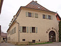
- The Lark's Nest is a small farmer's property in Franconian half-timbered construction , where Frederick the Great stayed overnight on the night of August 4th to 5th, 1730 on his attempt to escape. Crown Prince Friedrich had fled from his travel quarters near Steinsfurt together with the page Keith in order to evade the educational authority of his strict father, King Friedrich Wilhelm I , and to leave for France . However, he was arrested, placed under arrest in the Küstrin fortress , and had to watch the execution of his friend and confidante Katte there in November 1730 . The property, which was renovated in the 1970s, is now a museum.
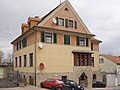
- The old barracks not far from the Lark's Nest is a half-timbered building from the 16th century, which was rebuilt in 1626 and 1704 after previous war damage. The cellar with its historic cross vault was a meeting place for Anabaptists in 1661 .
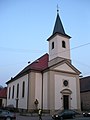
- The Catholic Church of St. Peter was built in 1803/04 instead of a previous structure from 1662/63. In front of the church is a sandstone statue of the bridge saint Johannes Nepomuk from 1742, which was on the Elsenz Bridge until the middle of the 19th century.
- The Evangelical Church was built in 1936/1937 according to plans by the Mannheim architect Christian Schrade and inaugurated on November 28, 1937. There is also a Protestant kindergarten by the church, which was built in 1884 and rebuilt and expanded in 1955 and 1988.
- The old evangelical church was built in 1769/70 by the reformed community and used by the united evangelical community from 1821. After the Protestant church was rebuilt in 1936/37, the old church was first used as a cinema after the war and then as an inn.
- The Steinsfurt synagogue was built in 1893 by the Steinsfurt Jewish community according to plans by Wilhelm Dick from Hoffenheim and used as a place of worship until 1936. The brick building has been privately owned since 1938 and was named " Monument of the Month July 2008" by the Baden-Württemberg Monument Foundation.
Catholic Church of St. Peter

Protestant church

Old Protestant Church

synagogue


- The mill was mentioned as the mill of the Sinsheimer Stift as early as 1541 and has been expanded and renewed several times over the years. In 1907 the water wheel was replaced by a turbine and electricity was produced for the community from the following year. The mill's residential building was renovated in 1929, and the mill was modernized in 1934.
- The cooking and advanced training school was donated by Hermann Weil in 1923/24 . Today the building is mainly used for residential purposes.

Bridge saint John of Nepomuk

Jupiter figure

Barn near the mill
Cooking school


- In the center of the village by the modern administration and a replica of the Jupiter giant column is the teacher's house built in 1911 on the site of the former community bakery.
- In Steinsfurt there are also other historical buildings from different eras, including farm buildings such as the old wine press and the sheep house , the historical train station building in the classicism style and various historical residential buildings.

Teacher's house
Old wine press

Sheep house

railway station


- The Ansbach recreation facility is a public square that was designated as Tuchbleiche in 1866 and was later also a fairground . In the 1960s, the square was redesigned into a green area. In 1963 a memorial for the dead of both world wars was erected. The House of Hohenzollern donated a metal relief of Frederick the Great, which was mounted on the base stone of an earlier war memorial.
Bicycle traffic
The Kraichgau-Stromberg Castle Tour runs through Steinsfurt , a 52-kilometer regional cycle route that connects the village with the towns of Rohrbach and Weiler.
Personalities
- Peter Stephens (1687–1757), pioneer, founder of Stephens City, Virginia .
- Hermann Weil (1868–1927), entrepreneur and patron
- Karl Völker (1923–2009), entrepreneur and founder
- Erich Würfel (1926–2015), lawyer, local politician, politician, Landrat Landkreis Rastatt 1973–1989
- Gerd Hockenberger (* 1941), farmer and president of the state farmers' association in Baden-Württemberg
Individual evidence
- ↑ Geographical location and neighbors according to: Landesanstalt für Umwelt Baden-Württemberg (LUBW) ( information ) - detail map
- ↑ Josef Schmithüsen : Geographical land survey: The natural space units on sheet 161 Karlsruhe. Federal Institute for Regional Studies, Bad Godesberg 1952. → Online map (PDF; 5.1 MB)
- ^ Federal Statistical Office (ed.): Historical municipality directory for the Federal Republic of Germany. Name, border and key number changes in municipalities, counties and administrative districts from May 27, 1970 to December 31, 1982 . W. Kohlhammer, Stuttgart / Mainz 1983, ISBN 3-17-003263-1 , p. 479 .
- ^ Federal Statistical Office (ed.): Official municipality directory for the Federal Republic of Germany. Final results after the census of September 13, 1950 (= Statistics of the Federal Republic of Germany . Volume 33 ). W. Kohlhammer, Stuttgart / Cologne 1952, p. 122 ( digital version [PDF; 27.1 MB ]).
- ↑ Hans Appenzeller, Ortschronik, Vol. 3.
- ^ The synagogue in Steinsfurt (city of Sinsheim, Rhein-Neckar district) . alemannia-judaica.de.
- ↑ Hans Appenzeller, Ortschronik, Vol. 3, p. 10.
- ↑ Kraichgau-Stromberg: Castle Tour | Vacation country Baden-Wuerttemberg. Retrieved June 21, 2020 .
literature
- Hans Appenzeller: Ortschronik Steinsfurt . 4 volumes (1987–2002), without ISBN
Web links
- Website www.steinsfurt.de for Steinsfurt
- Map of the Steinsfurt district on: State Institute for the Environment Baden-Württemberg (LUBW) ( information )
- Map of Steinsfurt on: State Institute for the Environment Baden-Württemberg (LUBW) ( Notes )

Adersbach | Dühren | Ehrstädt | Eschelbach | Hasselbach | Hilsbach | Hoffenheim | Core city | Rows | Rohrbach | Steinsfurt | Forest fishing hole | hamlet